samit kafle (@samitkafle67) 's Twitter Profile
samit kafle

@samitkafle67

ID: 2969083499

calendar_today09-01-2015 03:19:22

27 Tweet

2 Followers

125 Following

Qiusheng Wu (@giswqs) 's Twitter Profile Photo

geospatial v0.8.0 is out - A Python package for installing commonly used packages for geospatial analysis and data visualization with only one command mamba install -c conda-forge geospatial GitHub: github.com/opengeos/geosp… Docs: geospatial.gishub.org

geospatial v0.8.0 is out - A Python package for installing commonly used packages for geospatial analysis and data visualization with only one command 

mamba install -c conda-forge geospatial 

GitHub: github.com/opengeos/geosp… 
Docs: geospatial.gishub.org
PYOFLIFE.COM (@parajulisaroj16) 's Twitter Profile Photo

Spatial regression analysis is a statistical technique used to model spatial relationships between variables. pyoflife.com/an-introductio… #DataScience #rstats #DataScientists #R #programming #dataanalysis #coding

Spatial regression analysis is a statistical technique used to model spatial relationships between variables. pyoflife.com/an-introductio… #DataScience #rstats #DataScientists #R #programming #dataanalysis #coding
Milos Makes Maps (@milosmakesmaps) 's Twitter Profile Photo

Hey people, I prepared a video tutorial on making POWERFUL 3D maps with #rayshader & #ggplot2 in R! 🔗youtu.be/bvlB5yb_uVQ #tutorial #coding #RStats #DataScience #dataviz #maps #gischat

Hey people, I prepared a video tutorial on making POWERFUL 3D maps with #rayshader & #ggplot2 in R!

🔗youtu.be/bvlB5yb_uVQ

#tutorial #coding #RStats #DataScience #dataviz #maps #gischat
Frédéric Angelier (@fangelier) 's Twitter Profile Photo

🚨 PhD offer 🧬🔬🐦 From Neuroscience to Ecology: what is the impact of urban noise on the cognitive development of urban wildlife? Ecophy @ImagingBrain SBN Tweets SICB Division of Comparative Endocrinology @INSB_CNRS @INEE_CNRS Deadline: 15/05 Private message if interested

🚨 PhD offer 🧬🔬🐦
From Neuroscience to Ecology: what is the impact of urban noise on the cognitive development of
urban wildlife? <a href="/Ecophy_CEBC/">Ecophy</a> @ImagingBrain
<a href="/SBNTweets/">SBN Tweets</a> <a href="/SICB_DCE/">SICB Division of Comparative Endocrinology</a> @INSB_CNRS @INEE_CNRS
Deadline: 15/05
Private message if interested
Dr. Joanne C. White (@joanne_c_white) 's Twitter Profile Photo

Thread by Mike Wulder: The best-available-pixel (BAP) tool you have been waiting for! Implemented on #GoogleEarthEngine (#GEE). #Landsat In #GEEBAP can tune composite parameters, create a #timeseries, set area of i...… threadreaderapp.com/thread/1387829…

Qiusheng Wu (@giswqs) 's Twitter Profile Photo

A sneak peak of segment-geospatial v0.4.0 - Automatically generating object masks for satellite imagery GitHub: github.com/opengeos/segme… Notebook: …57d2610e3302e55--opengeos.netlify.app/examples/autom… #geospatial #deeplearning #segmentanything

Dr. Carlos Alberto Silva 🌲🌍🛰 (@web_lidar) 's Twitter Profile Photo

📢 Our new paper led by Rodes - Blanco and MarianoGarcia et al is out. Canopy gap patterns in Mediterranean forests: a spatio-temporal characterization using airborne LiDAR data. Landscape Ecology link.springer.com/article/10.100…

📢 Our new paper led by Rodes - Blanco and <a href="/M4R14N0_22/">MarianoGarcia</a>  et al is out. Canopy gap patterns in Mediterranean forests: a spatio-temporal characterization using airborne LiDAR data. Landscape Ecology link.springer.com/article/10.100…
SatWorld (@or_bit_eye) 's Twitter Profile Photo

🔴⚠️🔥Terrifying evolution of the more than 80 current #Wildfires in #Alberta, as captured by #GOES18 today May 5 in the latest 7 hours via #ABFire Zoom Earth #Canada #ClimateEmergency #ClimateCrisis #climatebrawl AI6YR #StormHour Gerald Kutney - "Climate Denial in Amer. Politics"

Ed Mitchard 🛰️ (@edmitchard) 's Twitter Profile Photo

PLEASE RETWEET We Space Intelligence 🚀🛰️🌎🗺️ are looking for an AI R&D Lead Our mission is to enable zero deforestation and degradation, & support mass restoration of biodiverse forests globally. We need someone to help us develop the next generation of land cover and biomass change maps

PLEASE RETWEET

We <a href="/SpaceIntell/">Space Intelligence 🚀🛰️🌎🗺️</a> are looking for an AI R&amp;D Lead 

Our mission is to enable zero deforestation and degradation, &amp; support mass restoration of biodiverse forests globally. 

We need someone to help us develop the next generation of land cover and biomass change maps
NASAARSET 🛰🌎 (@nasaarset) 's Twitter Profile Photo

Learn to use NASA tools and data to assess fire impacts on land cover and #watershed conditions in our newly-opened training. Register here: go.nasa.gov/3BtmiTb

Learn to use NASA tools and data to assess fire impacts on land cover and #watershed conditions in our newly-opened training.
Register here: go.nasa.gov/3BtmiTb
PYOFLIFE.COM (@parajulisaroj16) 's Twitter Profile Photo

Violin plots are a popular method for visualizing the distribution of a dataset.  pyoflife.com/creating-violi… #DataScience #rstats #DataAnalytics #r #programming #Datavisualization

Violin plots are a popular method for visualizing the distribution of a dataset.  pyoflife.com/creating-violi…
#DataScience #rstats #DataAnalytics #r #programming #Datavisualization
Saverio Francini (@saveriofrancini) 's Twitter Profile Photo

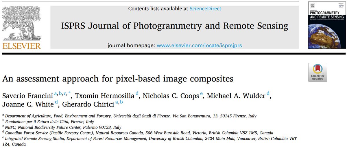
📢📢📢#NewPaper out in ISPRS Journal of Photogrammetry and Remote Sensing!!! It is about assessing pixel-based composites, which should be the first key step in many #RemoteSensing applications. doi.org/10.1016/j.ispr… #Landsat #GoogleEarthEngine #GEE #GEEBAP #OpenAccess

📢📢📢#NewPaper out in <a href="/isprs/">ISPRS</a>
Journal of Photogrammetry and Remote Sensing!!!

It is about assessing pixel-based composites, which should be the first key step in many #RemoteSensing applications. 

doi.org/10.1016/j.ispr…

#Landsat #GoogleEarthEngine #GEE #GEEBAP #OpenAccess
Ujaval Gandhi (@spatialthoughts) 's Twitter Profile Photo

The workshop starts with an introduction to the GEE charting API. Module 1 covers Time-Series charts with a focus on learning the API and customization options. We work with Weather Forecast (GFS), Climate (TerraClimate), Precipitation (CHIRPS), and MODIS datasets. (2/n)

The workshop starts with an introduction to the GEE charting API.  Module 1 covers Time-Series charts with a focus on learning the API and customization options. We work with Weather Forecast (GFS),  Climate (TerraClimate), Precipitation (CHIRPS), and MODIS datasets. (2/n)
Dr. Laura Chasmer (@erspeat) 's Twitter Profile Photo

3rd year of measuring NG-CFFDRS wildland fire fuel plots coincident with airborne and drone #lidar, this time in NWT and Yukon! With Emily Jones and @artemis_lab, supported by Canada Wildfire and NSERC / CRSNG

3rd year of measuring NG-CFFDRS wildland fire fuel plots coincident with airborne and drone #lidar, this time in NWT and Yukon! With <a href="/em_ajone/">Emily Jones</a> and @artemis_lab, supported by <a href="/CanadaWildfire/">Canada Wildfire</a> and <a href="/NSERC_CRSNG/">NSERC / CRSNG</a>
Michael Norton (@northern_norton) 's Twitter Profile Photo

Great presentation from our newest scientist Zhouxin Xi yesterday. His latest research with ULethbridge used terrestrial laser scanning to classify fuels in mountain pine beetle-attacked stands.

Great presentation from our newest scientist Zhouxin Xi yesterday. His latest research with <a href="/uLethbridge/">ULethbridge</a> used terrestrial laser scanning to classify fuels in mountain pine beetle-attacked stands.
Dr. Laura Chasmer (@erspeat) 's Twitter Profile Photo

New paper on using terrestrial #lidar & deep learning AI of fuels and fuel distribution in mountain pine beetle and reference pine stands Jasper National Park, Parks Canada! An outcome of fRI Research Federal-Provincial MPB program, Mitacs and Canada Wildfire. Find it here: mdpi.com/2072-4292/15/1…

New paper on using terrestrial #lidar &amp; deep learning AI of fuels and fuel distribution in mountain pine beetle and reference pine stands <a href="/JasperNP/">Jasper National Park, Parks Canada</a>! An outcome of <a href="/fRIresearch/">fRI Research</a> Federal-Provincial MPB program, <a href="/MitacsCanada/">Mitacs</a> and <a href="/CanadaWildfire/">Canada Wildfire</a>. Find it here: mdpi.com/2072-4292/15/1…