Meteorologist Ryan Kudish (@rykudishwx) 's Twitter Profile
Meteorologist Ryan Kudish

@rykudishwx

Meteorologist/Reporter @WFRVLocal5 Green Bay, WI📍🌨️| @PlymouthState Alumni ‘22/G’23 | Rhody Born and Raised⚓️ | Former Swimmer 🏊🏻‍♂️| Boston Sports Guy

ID: 714585795387072512

linkhttps://www.wearegreenbay.com/ calendar_today28-03-2016 22:51:44

6,6K Tweet

560 Takipçi

700 Takip Edilen

Meteorologist Ryan Kudish (@rykudishwx) 's Twitter Profile Photo

Good morning! Besides a stray shower this morning, plan on a nice mix of sun & clouds. Anytime after 2pm, plan on a chance for a pop up thunderstorm. No severe weather, but gusty winds and downpours would be the main impacts. Humidity ramps up again, with highs om the 70s and

Good morning! Besides a stray shower this morning, plan on a nice mix of sun & clouds.

Anytime after 2pm, plan on a chance for a pop up thunderstorm. No severe weather, but gusty winds and downpours would be the main impacts.

Humidity ramps up again, with highs om the 70s and
Meteorologist Ryan Kudish (@rykudishwx) 's Twitter Profile Photo

Now with our morning rain chance out of the way, now keep your eye to the sky for some pop up storms anytime after 2-3pm. Noon forecast:

Meteorologist Ryan Kudish (@rykudishwx) 's Twitter Profile Photo

5PM Radar update: Great to be back in the office today. Tracking a few isolated showers and downpours working through areas S/W of Lake Winnebago. Most should stay dry tonight, but a stray shower or storm is possible areas south of Green Bay tonight into Friday Morning

5PM Radar update: Great to be back in the office today.

Tracking a few isolated showers and downpours working through areas S/W of Lake Winnebago. Most should stay dry tonight, but a stray shower or storm is possible areas south of Green Bay tonight into Friday Morning
Meteorologist Ryan Kudish (@rykudishwx) 's Twitter Profile Photo

A stray shower or storm chance tonight, more unsettled weather Friday evening into Saturday mid day. Full forecast: wearegreenbay.com/weather/clouds…

Meteorologist Ryan Kudish (@rykudishwx) 's Twitter Profile Photo

Tomorrow, plan on highs in the upper 70s and low 80s with muggy dew points closing in on 70. In terms of the rain, spotty showers S/W of Green Bay for the AM. Dry for mid day. Evening plans may be e bit wet with scattered showers and a few rumbles of thunder. Overall severe

Tomorrow, plan on highs in the upper 70s and low 80s with muggy dew points closing in on 70.

In terms of the rain, spotty showers S/W of Green Bay for the AM. Dry for mid day. Evening plans may be e bit wet with scattered showers and a few rumbles of thunder.

Overall severe
Meteorologist Ryan Kudish (@rykudishwx) 's Twitter Profile Photo

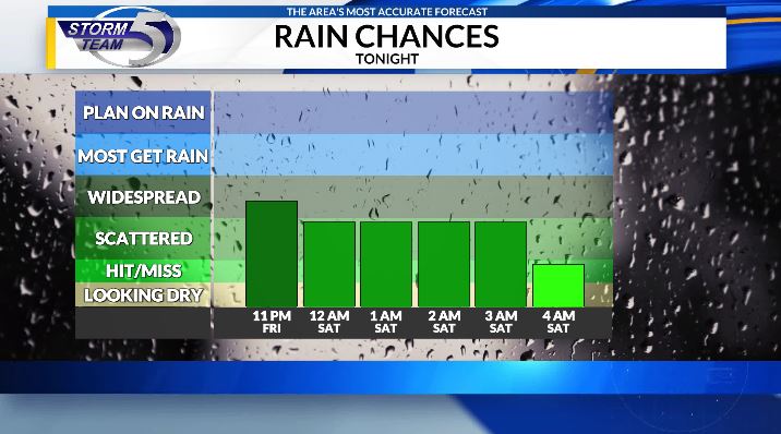
10PM UPDATE: Opted to make some changes to the arrival time of our best chance at seeing rain tomorrow. Looks like now the best chance holds off until overnight Friday. Forecast:

Meteorologist Ryan Kudish (@rykudishwx) 's Twitter Profile Photo

4PM Friday Radar Update: A cluster of showers and storms has developed in Iowa and is sparking some severe weather. Severe weather here is not expected tonight. There is a chance for an isolated shower this evening, but rain chances become more widespread anytime after 8-9pm.

4PM Friday Radar Update: A cluster of showers and storms has developed in Iowa and is sparking some severe weather. Severe weather here is not expected tonight.

There is a chance for an isolated shower this evening, but rain chances become more widespread anytime after 8-9pm.
Meteorologist Ryan Kudish (@rykudishwx) 's Twitter Profile Photo

On Saturday, besides a few lingering showers, our day starts quiet. Anytime after 11am through 5pm, a cold front will spark a broken line of rain & storms. Widespread severe weather is unlikely, but a storm or two could trigger a warning with hail, downpours and gusty winds

On Saturday, besides a few lingering showers, our day starts quiet.

Anytime after 11am through 5pm, a cold front will spark a broken line of rain & storms.

Widespread severe weather is unlikely, but a storm or two could trigger a warning with hail, downpours and gusty winds
Meteorologist Ryan Kudish (@rykudishwx) 's Twitter Profile Photo

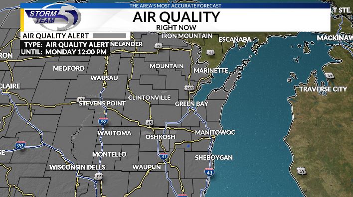
NEW: An Air Quality Alert has been issued all the way through Monday at 12pm as our next system will likely bring in unhealthy levels of wildfire smoke.

NEW: An Air Quality Alert has been issued all the way through Monday at 12pm as our next system will likely bring in unhealthy levels of wildfire smoke.
Meteorologist Ryan Kudish (@rykudishwx) 's Twitter Profile Photo

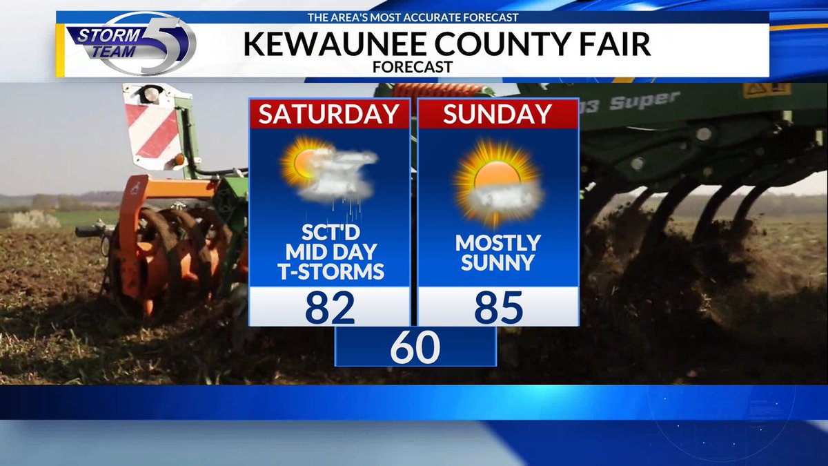
Heading to the Kewaunee County Fair this weekend? While we do have a storm chance tomorrow mid, the evening it looking dry and Sunday is looking great! Enjoy!

Heading to the Kewaunee County Fair this weekend? While we do have a storm chance tomorrow mid, the evening it looking dry and Sunday is looking great! Enjoy!
Meteorologist Ryan Kudish (@rykudishwx) 's Twitter Profile Photo

8:15 Radar Check Friday: light to moderate rain moving into the area pretty much as expected. It should stay mainly rain, but a few rumbles of thunder and heavy downpours are possible tonight

8:15 Radar Check Friday: light to moderate rain moving into the area pretty much as expected. It should stay mainly rain, but a few rumbles of thunder and heavy downpours are possible tonight
Meteorologist Ryan Kudish (@rykudishwx) 's Twitter Profile Photo

The rain has moved in on this Friday night, expect it to stay with us overnight followed by the potential for strong storms Saturday mid day 10PM Forecast: