🔴All India Weather
@pkusrain
📙 Lead by Dr. Pradeep who is a Climate Scientist with Phd, M-Tech in Meteorology from IISc | Views: Personal and Educational | Follow IMD for official Alert |
ID: 1003195562806538242
https://www.linkedin.com/in/pradeepkushwahaiisc?utm_source=share&utm_campaign=share_via&utm_content= 03-06-2018 08:43:55
8,8K Tweet
7,7K Takipçi
333 Takip Edilen
 on Twitter photo Many questions are being asked about whether the west UP system will reach Delhi NCR and Haryana. Currently, it is moving in a northeast direction. However, after 1-2 hours, it will turn west-northwest. It will weaken gradually, but it may marginally affect parts of south Haryana")
 on Twitter photo Massive thunderstorms now heading towards central UP. Kanpur, Lucknow and nearby regions receiving heavy showers. Stay safe..")
 on Twitter photo By looking at that image please guess upto where monsoon has arrived..")
 on Twitter photo Monsoon is gaining momentum over the Indo-Gangetic plains and arrived over Uttar Pradesh. Most of central, eastern and northeastern India is covered by clouds. Only Jammu and Kashmir, Punjab, northwest Rajasthan and Haryana have clear skies now. We can expect monsoon onset over")
 on Twitter photo Today's rainfall forecast by IMD GFS.")
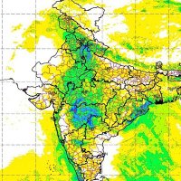
 on Twitter photo Next 24 hours rainfall alert:
Heavy rain expected over south Rajasthan, south UP , southwest Jharkhand, northeast MP and parts of West UP.
Isolated thunderstorms expected over northeast India, north Odisha Madhya Pradesh, Chattisgarh, south Bihar, Uttrakhand and parts of")
 on Twitter photo Maximum rainfall over core monsoon zone. Even parts of Punjab experiencing thunderstorms because of convergence of moisture.")
 on Twitter photo As expected monsoon has now covered most parts of country. Only same parts of northwest India remain and will be covered in next 5-7 day's.. overall historical monsoon progress..")
 on Twitter photo A nice monsoon thunderstorms approaching parts of Bengaluru. Short intense spells expected over north, northeast and east Bengaluru in next 1-2 hours..#bengalururain #Bengaluru")
 on Twitter photo Southeast Rajasthan continue to get great monsoon rainfall")
 on Twitter photo The circulation again moved towards Rajasthan. Heavy rain observed over several parts of central to south Rajasthan and north and west Gujarat. Remain Watchful more rain expected.")
 on Twitter photo Heavy rain alert for next 24 hours.
Parts of central to south Rajasthan, north and east Gujarat, northeast and parts of north Madhya Pradesh , north Chattisgarh, south Jharkhand may experience moderate to heavy rain.
Jammu Kashmir, Himachal, Uttrakhand, coastal Karnataka,")