Nusantara Atlas by The TreeMap (@nusantara_atlas) 's Twitter Profile
Nusantara Atlas by The TreeMap

@nusantara_atlas

🌐 Web App Aimed at Protecting Tropical Forests
🔬 Scientific Data + Satellite Monitoring
🌍 Nusantara Atlas Track Deforestation in Real Time
🛰 Time-lapses

ID: 1630569790749155330

linkhttp://nusantara-atlas.org calendar_today28-02-2023 14:05:38

98 Tweet

176 Takipçi

65 Takip Edilen

Sustainable Palm Oil Choice (also on BlueSky) (@palmchoice) 's Twitter Profile Photo

"In 2024, the conversion of old-growth forests to industrial palm oil plantations in Indonesia slowed slightly compared to 2023." By choosing only #SUSTAINABLE #PalmOil we can all contribute to driving down deforestation. nusantara-atlas.org/industrial-pal… Nusantara Atlas by The TreeMap David Gaveau

Nusantara Atlas by The TreeMap (@nusantara_atlas) 's Twitter Profile Photo

"The TreeMap has released satellite images of Bali from 1965. Now available on Nusantara Atlas, these images were captured by the KH-7 Gambit satellite, which was used on a top-secret U.S. reconnaissance mission during the Cold War." Time Out Group #Bali timeout.com/asia/news/see-…

Nusantara Atlas by The TreeMap (@nusantara_atlas) 's Twitter Profile Photo

Satellite analysis confirms that deforestation inside Indonesia’s Rawa Singkil Wildlife Reserve has not slowed. Rainforest Action Network & Nusantara Atlas by The TreeMap reveals hi-res Airbus satellite imagery that ongoing illegal #PalmOil expansion within this critical #ecosystem

Satellite analysis confirms that deforestation inside Indonesia’s Rawa Singkil Wildlife Reserve has not slowed. Rainforest Action Network &amp; <a href="/nusantara_atlas/">Nusantara Atlas by The TreeMap</a>   reveals hi-res <a href="/Airbus/">Airbus</a> satellite imagery that ongoing illegal #PalmOil  expansion within this critical #ecosystem
Nusantara Atlas by The TreeMap (@nusantara_atlas) 's Twitter Profile Photo

In 08/24, hundreds of excavators arrived in Wanam and Wogikel to begin clearing land for a logistics seaport and a 135 km Food Estate Road. By 12/12/24 - 4,200 hectares had been bulldozed, with drainage canals under construction. Explore the imagery on the Nusantara Atlas by The TreeMap

Nusantara Atlas by The TreeMap (@nusantara_atlas) 's Twitter Profile Photo

Assessing Merauke’s Wetlands: Is This Land Suitable for Large-Scale Rice Cultivation? This ecosystem defined by Melaleuca forests, tropical savanna, and wetlands - raises critical questions about the feasibility of the food estate projects. Read more nusantara-atlas.org/indonesias-rac…

Nusantara Atlas by The TreeMap (@nusantara_atlas) 's Twitter Profile Photo

Using the Pléiades Neo to capture ultra-hi-def imagery of Rawa Singkil. This was combined with TripleSat and 21AT imagery from 2016 and Planet/NICFI data from 2020 to track illegal #deforestation. At least 300ha of peat-swamp forest has been cleared since 09/2024. #indonesia

Nusantara Atlas by The TreeMap (@nusantara_atlas) 's Twitter Profile Photo

To highlight the extraordinary biodiversity of #Merauke, Nusantara Atlas by The TreeMap has geo-tagged a series of aerial photographs taken by ulet ifansasti for Greenpeace International on the Rainbow Warrior’s 2018 tour. Watch the video on the geo-tag photos function to explore these images interactively.

Nusantara Atlas by The TreeMap (@nusantara_atlas) 's Twitter Profile Photo

On Friday, 28 March, a 7.1-magnitude earthquake struck near Mandalay, causing over 3,000 fatalities in Myanmar and 19 in Thailand. Our heart goes out to the families impacted by the natural disaster. #mandalay #myanmar

Dyna Rochmyaningsih (@rochmyaningsih) 's Twitter Profile Photo

Indonesia's food estate program is not only socially problematic, it is SCIENTIFICALLY BASELESS. My latest reporting for News from Science! science.org/content/articl…

News from Science (@newsfromscience) 's Twitter Profile Photo

Poor soils and a dry climate could undermine Indonesia’s effort to expand rice growing by 1 million hectares, experts warn. scim.ag/3YoA4SH

Nusantara Atlas by The TreeMap (@nusantara_atlas) 's Twitter Profile Photo

📉 Deforestation for pulpwood in Indonesia dropped 69% in 2024 after a decade-high in 2023, according to Nusantara Atlas by The TreeMap Most declines came from fewer clearings by PT Mayawana Persada & PT Industrial Forest Plantation—but 1.1M ha of forest remains at risk. #Deforestation
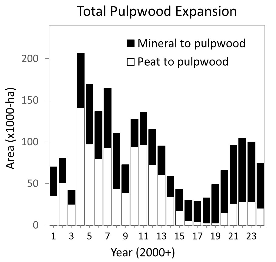
📉 Deforestation for pulpwood in Indonesia dropped 69% in 2024 after a decade-high in 2023, according to <a href="/nusantara_atlas/">Nusantara Atlas by The TreeMap</a> 

Most declines came from fewer clearings by PT Mayawana Persada &amp; PT Industrial Forest Plantation—but 1.1M ha of forest remains at risk.
#Deforestation
Nusantara Atlas by The TreeMap (@nusantara_atlas) 's Twitter Profile Photo

On this #EarthDay2025 we recommit to: 🔎Making environmental change visible 📊 Backing advocacy with data 🌱 Supporting those working to protect our forests, wetlands, and wildlife Explore. Investigate. Understand. 🌐 nusantara-atlas.org -explore our reports and maps online

On this #EarthDay2025 we recommit to:
🔎Making environmental change visible
📊 Backing advocacy with data
🌱 Supporting those working to protect our forests, wetlands, and wildlife

Explore. Investigate. Understand.
🌐 nusantara-atlas.org -explore our reports and maps online
Nusantara Atlas by The TreeMap (@nusantara_atlas) 's Twitter Profile Photo

Researchers fear poor soils and a relatively dry climate could doom an Indonesian government plan to expand rice growing in Merauke. They note similar past efforts for crop production ended in failure. Reported by Dyna Rochmyaningsih for Science Magazine science.org/content/articl…

Nusantara Atlas by The TreeMap (@nusantara_atlas) 's Twitter Profile Photo

Support the upcoming film #TheLastPlaceonEarth from Oceanic Preservation Society / OPS Set in the extraordinary Leuser Ecosystem of Sumatra—one of the last places where endangered orangutans, tigers, elephants, and rhinos still coexist The documentary premieres this May at @mountainfilm

Support the upcoming film #TheLastPlaceonEarth from  <a href="/OP_Society/">Oceanic Preservation Society / OPS</a> 

Set in the extraordinary Leuser Ecosystem of Sumatra—one of the last places where endangered orangutans, tigers, elephants, and rhinos still coexist

The documentary premieres this May at @mountainfilm
Nusantara Atlas by The TreeMap (@nusantara_atlas) 's Twitter Profile Photo

#SaveRajaAmpat Protecting Paradise from Nickel Mining Ijowoyoo together with a coalition of Papuan youth and environmental activists, is leading a critical campaign to safeguard Raja Ampat, one of Earth's richest biodiversity hotspots. Join the movement! Dandhy Laksono

Nusantara Atlas by The TreeMap (@nusantara_atlas) 's Twitter Profile Photo

Satellite imagery from Nusantara Atlas by The TreeMap reveals alarming changes: a concession in #WestPapua previously inactive, is now among the top #deforestation hotspots. Between January and June 2025, our deforestation tracker recorded rapid clearing, vividly captured in this timelapse.

Nusantara Atlas by The TreeMap (@nusantara_atlas) 's Twitter Profile Photo

Using ARCHIVED - NASA Atmosphere GEOS-5 climate model, environmental scientist David Gaveau created this global simulation of aerosol movement — visualizing how forest fire smoke travels across continents and oceans. One planet. One atmosphere. One interconnected ecosystem #Earth

Nusantara Atlas by The TreeMap (@nusantara_atlas) 's Twitter Profile Photo

The new Compliance Tracker in Nusantara Atlas by The TreeMap helps prioritize land plots, such as concessions, mills, protected areas, villages, based on deforestation that occurred after key regulatory cut-off dates EUDR, RSPO, NDPE #deforestation #satellitetracking #EnvironmentalScience