Nick Moir (@nampix) 's Twitter Profile
Nick Moir

@nampix

Chief Photographer for The Sydney Morning Herald since 1993 Oculi.com.au specialising in stormchasing , severe weather , bushfires. Opinions are my own

ID: 283403633

linkhttp://www.oculi.com.au calendar_today17-04-2011 06:48:39

2,2K Tweet

4,4K Followers

132 Following

Laura Chung (@laura_r_chung) 's Twitter Profile Photo

Large parts of inland NSW have been transformed into a freshwater sea in just over a month. Where river beds lay cracked and dry three years ago, they are now flowing with brown floodwater after weeks of heavy rainfall smh.com.au/environment/we…

NSW RFS (@nswrfs) 's Twitter Profile Photo

#NSWRFS Euabolong Brigade has been working alongside the community to establish the 1.6km 'great wall of Euabolong', as flooding headed their way. The flood peaked yesterday at 7.82m and whilst sadly 1 home was impacted, the impressive levee saved every other home in the town.

SMH Photography (@photossmh) 's Twitter Profile Photo

The amazing SMH Photography AFR Photography #photojournalists have once again artfully captured the moments of the week to bring the news to life. Photos of the Week gallery smh.com.au/national/the-s… #Photos Kate Geraghty Wolter Peeters #UkraineWar #UkraineRussiaWar #SpencerTunick

The amazing <a href="/photosSMH/">SMH Photography</a> <a href="/afrphoto/">AFR Photography</a> #photojournalists have once again artfully captured the moments of the week to bring the news to life. Photos of the Week gallery smh.com.au/national/the-s… #Photos <a href="/geraghtyk/">Kate Geraghty</a> <a href="/ShooterWol/">Wolter Peeters</a> #UkraineWar #UkraineRussiaWar #SpencerTunick
Ben Domensino (@ben_domensino) 's Twitter Profile Photo

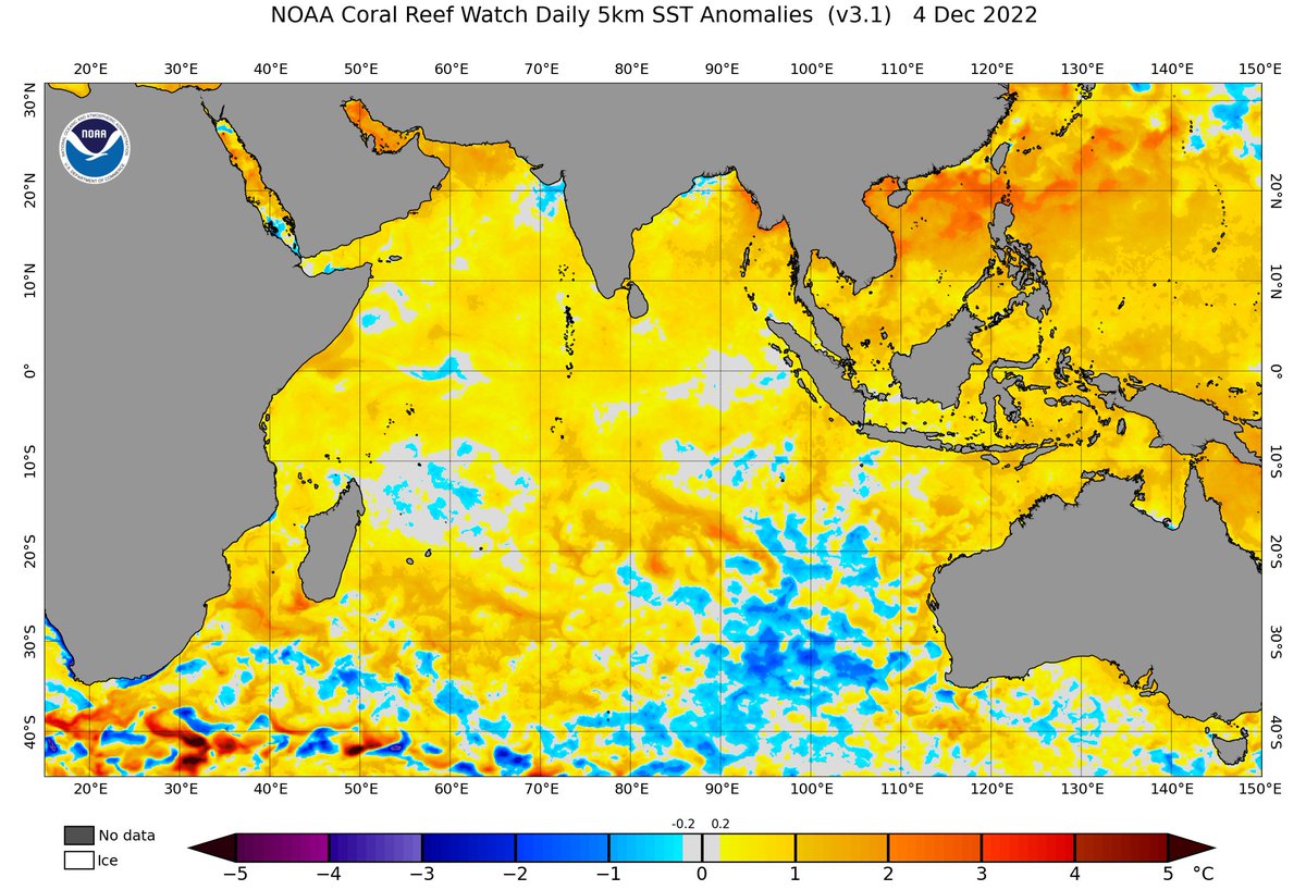
#Breaking - The Bureau of Meteorology, Australia has just declared the end of the 2022 negative Indian Ocean Dipole (IOD), bringing to an end one of the climate drivers that underpinned Australia's 2nd wettest spring on record. More details: weatherzone.com.au/news/the-2022-…
#Breaking - The <a href="/BOM_au/">Bureau of Meteorology, Australia</a> has just declared the end of the 2022 negative Indian Ocean Dipole (IOD), bringing to an end one of the climate drivers that underpinned Australia's 2nd wettest spring on record.

More details: weatherzone.com.au/news/the-2022-…
Ben Domensino (@ben_domensino) 's Twitter Profile Photo

#Sydney has now exceeded 2.5 metres of rain in 2022, more than doubling its long-term annual mean of 1213 mm and easily beating the city's previous annual record of 2194mm from 1950. Yearly rainfall records in Sydney date back to 1859. More details here: weatherzone.com.au/news/sydney-hi…

#Sydney has now exceeded 2.5 metres of rain in 2022, more than doubling its long-term annual mean of 1213 mm and easily beating the city's previous annual record of 2194mm from 1950. Yearly rainfall records in Sydney date back to 1859.

More details here: weatherzone.com.au/news/sydney-hi…
MNStorm (@mn_storm) 's Twitter Profile Photo

Close-up satellite loop showing multiple wildfires breaking out today in central Chile. Some of the fires appear to have ran 15-25 km. This is probably the worst wildfire outbreak in Chile since 2017.

Bureau of Meteorology, New South Wales (@bom_nsw) 's Twitter Profile Photo

Thunderstorm forecast tomorrow(20/02): Severe storms possible in the NW for Damaging winds gusts(=>90km/h, and in #CentralTablelands & #BlueMts for heavy rainfall. Locations include #Cobar, #Bourke, #Katoomba, #Orange and #Bathurst. Warnings if needed: ow.ly/kbXN50MWn4p

Thunderstorm forecast tomorrow(20/02): Severe storms possible in the NW for Damaging winds gusts(=&gt;90km/h, and in #CentralTablelands &amp; #BlueMts  for heavy rainfall. Locations include #Cobar, #Bourke, #Katoomba, #Orange and #Bathurst. Warnings if needed: ow.ly/kbXN50MWn4p
Reed Timmer, PhD (@reedtimmerusa) 's Twitter Profile Photo

I am very concerned about the overall pattern for tornado outbreaks this early spring as we finish March and into April. Long-range models show a pattern we see every 10 years or so - massive high amplitude storm system after storm system. Time is now to mentally and physically

I am very concerned about the overall pattern for tornado outbreaks this early spring as we finish March and into April. Long-range models show a pattern we see every 10 years or so - massive high amplitude storm system after storm system. Time is now to mentally and physically
NSW RFS (@nswrfs) 's Twitter Profile Photo

The Bushfire Seasonal Outlook for Spring has been released by AFAC. Large areas of central and northern NSW are expected to see increased risk of fire this spring along with parts of the coast and ranges not affected by the 2019/20 fires. More details brnw.ch/21wBTAI

The Bushfire Seasonal Outlook for Spring has been released by <a href="/AFACnews/">AFAC</a>. Large areas of central and northern NSW are expected to see increased risk of fire this spring along with parts of the coast and ranges not affected by the 2019/20 fires. More details brnw.ch/21wBTAI
Ben Domensino (@ben_domensino) 's Twitter Profile Photo

Absurd early-spring heat is about to hit #Sydney. The city is forecast to see 5 consecutive days >28°C. This has never been recorded in September before, with records dating back to 1859!

Absurd early-spring heat is about to hit #Sydney. The city is forecast to see 5 consecutive days &gt;28°C. This has never been recorded in September before, with records dating back to 1859!
Ben Domensino (@ben_domensino) 's Twitter Profile Photo

It's not even midday and Ulladulla is already having its hottest September day on record. 🥵 It had reached 32.6ºC by 11:40am, beating its old September record of 32.3ºC from 2017. Data for this site is available back to 1991.

It's not even midday and Ulladulla is already having its hottest September day on record. 🥵 It had reached 32.6ºC by 11:40am, beating its old September record of 32.3ºC from 2017. Data for this site is available back to 1991.
NSW RFS (@nswrfs) 's Twitter Profile Photo

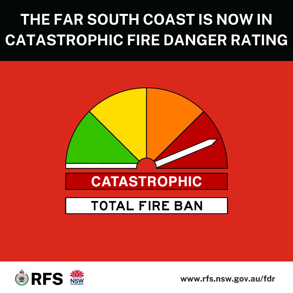
Due to stronger than forecast winds along the Far South Coast, Catastrophic fire danger is expected this afternoon. For your survival, avoid being in fire risk areas today. Stay up to date, review your bush fire survival plan and know what you will do if a fire threatens.

Due to stronger than forecast winds along the Far South Coast, Catastrophic fire danger is expected this afternoon. For your survival, avoid being in fire risk areas today. Stay up to date, review your bush fire survival plan and know what you will do if a fire threatens.
Ben Domensino (@ben_domensino) 's Twitter Profile Photo

This year's positive IOD just keeps getting stronger. 💪 The latest weekly IOD index value of +1.85ºC is only 0.3ºC below the peak of the record-challenging 2019 positive IOD event. More details on what this means for Australia here: weatherzone.com.au/news/positive-…

This year's positive IOD just keeps getting stronger. 💪 The latest weekly IOD index value of +1.85ºC is only 0.3ºC below the peak of the record-challenging 2019 positive IOD event.

More details on what this means for Australia here: weatherzone.com.au/news/positive-…
Ben Domensino (@ben_domensino) 's Twitter Profile Photo

Oodnadatta's final maximum temperature today was 38.5°C. This is more than 16°C above average for this time of year. It's also the highest winter temperature ever observed in South Australia, obliterating the previous record of 36.5°C from the same site on August 12, 1946.

Oodnadatta's final maximum temperature today was 38.5°C. This is more than 16°C above average for this time of year. It's also the highest winter temperature ever observed in South Australia, obliterating the previous record of 36.5°C from the same site on August 12, 1946.