MO Div. of Fire Safety (@mofiremarshal) 's Twitter Profile
MO Div. of Fire Safety

@mofiremarshal

The Missouri Division of Fire Safety provides enforcement, oversight and education to protect lives and property. Not monitored 24/7. For emergencies call 911.

ID: 905493327814041600

linkhttp://www.dfs.dps.mo.gov calendar_today06-09-2017 18:10:07

5,5K Tweet

2,2K Takipçi

226 Takip Edilen

Governor Mike Kehoe (@govmikekehoe) 's Twitter Profile Photo

Governor Kehoe Announces Activation of the Missouri National Guard to Support Tornado Recovery Operations in St. Louis 🔗governor.mo.gov/press-releases… Through this deployment, the State of Missouri is further assisting the City of St. Louis in recovery efforts following the

Governor Kehoe Announces Activation of the Missouri National Guard to Support Tornado Recovery Operations in St. Louis
🔗governor.mo.gov/press-releases…

Through this deployment, the State of Missouri is further assisting the City of St. Louis in recovery efforts following the
Missouri State Emergency Management Agency (@mosema_) 's Twitter Profile Photo

‼️⚠️Flash flooding in southern MO has led to water rescues and washed out low-water crossings and damaged bridges. ⚠️Nighttime flooding is particularly dangerous because of low visibility. Go slow! ⚠️Never drive into a flooded road! ⚠️More rain is coming. Watch for #MoWx updates

MO Div. of Fire Safety (@mofiremarshal) 's Twitter Profile Photo

On #MemorialDay2025 we honor and remember those who made the ultimate sacrifice for defending freedom around the globe. We are eternally grateful for the service of these American heroes.

On #MemorialDay2025 we honor and remember those who made the ultimate sacrifice for defending freedom around the globe. We are eternally grateful for the service of these American heroes.
Missouri State Emergency Management Agency (@mosema_) 's Twitter Profile Photo

⚠️Flood Watch in effect for much of Missouri thru WED morning ⚠️Several rounds of storms expected with potentially very heavy rainfall - 1-3” in watch area, w/ highly localized amounts exceeding 6” possible. ⚠️Potential exists for Severe Storms, with damaging winds & large hail

⚠️Flood Watch in effect for much of Missouri thru WED morning
⚠️Several rounds of storms expected with potentially very heavy rainfall - 1-3” in watch area, w/ highly
localized amounts exceeding 6” possible.
⚠️Potential exists for Severe Storms, with damaging winds & large hail
Missouri State Emergency Management Agency (@mosema_) 's Twitter Profile Photo

‼️⚠️Flood Watch remains in effect through noon TODAY for parts of SWMO! ⚠️More thunderstorms this morning could result in localized rainfall amounts up to 3 inches. ⚠️Also, 1-2 inches, and up to 3 inches in local areas, along the I-44 corridor could cause localized flash flooding

‼️⚠️Flood Watch remains in effect through noon TODAY for parts of SWMO!
⚠️More thunderstorms this morning could result in localized rainfall amounts up to 3 inches.
⚠️Also, 1-2 inches, and up to 3 inches in local areas, along the I-44 corridor could cause localized flash flooding
Capitol Police (@mocapitolpolice) 's Twitter Profile Photo

📣Capitol Police is seeking a Dispatcher/Record Clerk to maintain radio traffic & CAD entries of officer activities for the 3PM-11PM shift. This is a full-time position with all state benefits – vacation, health insurance, retirement plan. Details/apply: mocareers.mo.gov/hiretrue/ce3/j…


📣<a href="/MoCapitolPolice/">Capitol Police</a> is seeking a Dispatcher/Record Clerk to maintain radio traffic &amp; CAD entries of officer activities for the 3PM-11PM shift. This is a full-time position with all state benefits – vacation, health insurance, retirement plan. Details/apply: mocareers.mo.gov/hiretrue/ce3/j…
Missouri State Emergency Management Agency (@mosema_) 's Twitter Profile Photo

‼️⚠️The severe storm and flash flooding threat has not abated ⚠️A new Flood Watch has been issued from 4am-1pm Friday for SWMO & South Central MO ⚠️Additional thunderstorms may produce more heavy rain and flooding overnight - tomorrow morning. ✅Never drive onto a flooded roadway

Governor Mike Kehoe (@govmikekehoe) 's Twitter Profile Photo

President Trump has approved a federal Disaster Declaration for Individual Assistance and Public Assistance for St. Louis City, St. Louis County, and Scott County for the May 16 severe storms. Eligible homeowners and renters in those 3 jurisdictions can apply for assistance

President Trump has approved a federal Disaster Declaration for Individual Assistance and Public Assistance for St. Louis City, St. Louis County, and Scott County for the May 16 severe storms. 

Eligible homeowners and renters in those 3 jurisdictions can apply for assistance
MO Div. of Fire Safety (@mofiremarshal) 's Twitter Profile Photo

“The power of a dad in a child's life is unmatched.” Happy Father's Day to all the dads in #PublicSafety who instill strong values in their own children and those they meet and mentor on the job #FathersDay

“The power of a dad in a child's life is unmatched.” Happy Father's Day to all the dads in #PublicSafety who instill strong values in their own children and those they meet and mentor on the job #FathersDay
Governor Mike Kehoe (@govmikekehoe) 's Twitter Profile Photo

From the moments immediately after the EF-3 tornado struck and each day since, Missourians have shown they will come to the aid for their neighbors, no matter how daunting the task before them. In our many visits to St. Louis over the last month, we have seen people come together

From the moments immediately after the EF-3 tornado struck and each day since, Missourians have shown they will come to the aid for their neighbors, no matter how daunting the task before them. In our many visits to St. Louis over the last month, we have seen people come together
Missouri State Emergency Management Agency (@mosema_) 's Twitter Profile Photo

‼️⚠️Severe Storms risk late today/this evening & again Wednesday afternoon/night. ⚠️Highest risk is for strong winds with lesser risk of hail & tornadoes. ✅Remain weather aware & have several ways to get alerts in case one fails. ⚠️A mobile home does not provide protection

‼️⚠️Severe Storms risk late today/this evening &amp; again Wednesday afternoon/night. 
⚠️Highest risk is for strong winds with lesser risk of hail &amp; tornadoes. 
✅Remain weather aware &amp; have several ways to get alerts in case one fails. 
⚠️A mobile home does not provide protection
NWS Springfield (@nwsspringfield) 's Twitter Profile Photo

Severe thunderstorms look to move into the area from the west this afternoon into early Wednesday morning. Highest severe chances are along and west of Highway 65. All modes of severe weather will be possible. #mowx #kswx

Severe thunderstorms look to move into the area from the west this afternoon into early Wednesday morning. Highest severe chances are along and west of Highway 65.  All modes of severe weather will be possible. #mowx #kswx
NWS Springfield (@nwsspringfield) 's Twitter Profile Photo

Redevelopment of severe storms will be possible this afternoon into the evening if enough warming can occur. All modes of severe storms will be possible.

Redevelopment of severe storms will be possible this afternoon into the evening if enough warming can occur.  All modes of severe storms will be possible.
MO Div. of Fire Safety (@mofiremarshal) 's Twitter Profile Photo

.MO Div. of Fire Safety has a Senior Commissioned Investigator opening in Region A/H in NWMO. The selected applicant will be Missouri POST-licensed & will investigate the cause & origin of fires to assist law enforcement & fire service agencies. Details here: mocareers.mo.gov/hiretrue/ce3/j…

.<a href="/MoFireMarshal/">MO Div. of Fire Safety</a> has a Senior Commissioned Investigator opening in Region A/H in NWMO. The selected applicant will be Missouri POST-licensed &amp; will investigate the cause &amp; origin of fires to assist law enforcement &amp; fire service agencies. Details here: mocareers.mo.gov/hiretrue/ce3/j…
Missouri State Emergency Management Agency (@mosema_) 's Twitter Profile Photo

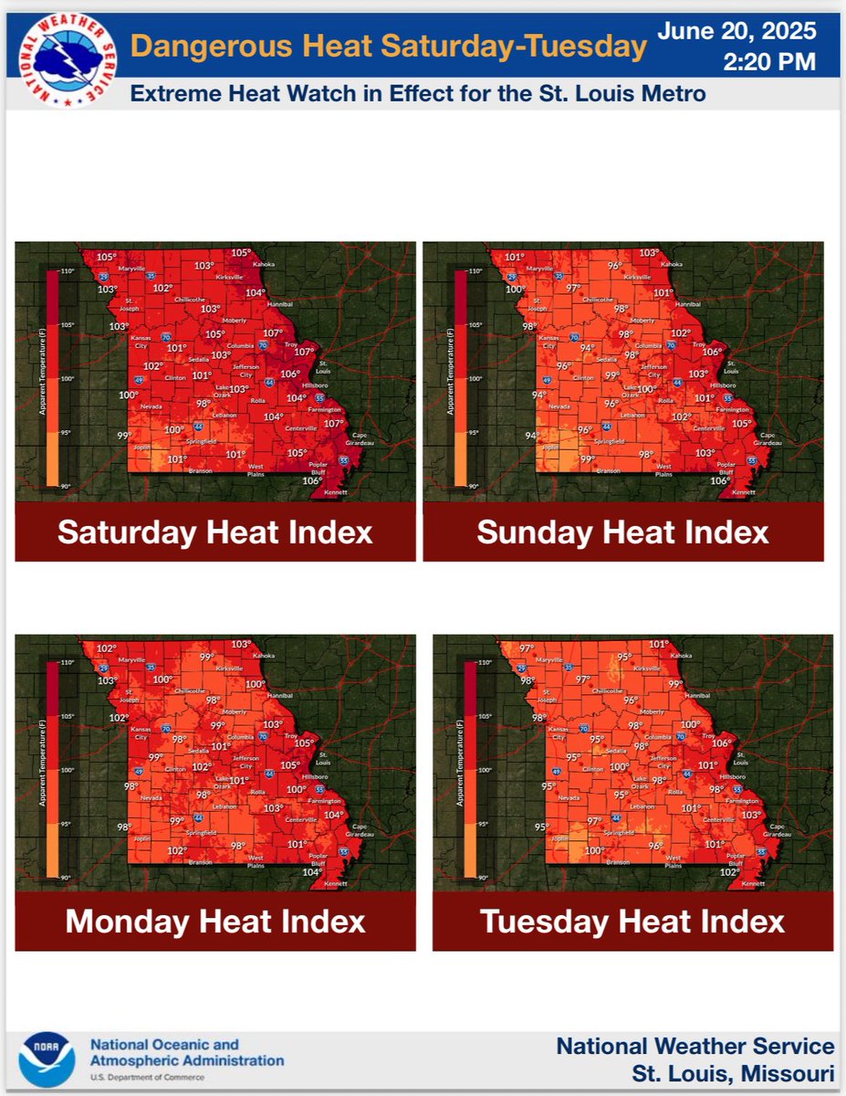
‼️⚠️Dangerous heat will affect Missouri through TUES ⚠️An Extreme Heat Warning has been issued for the St. Louis Metro SAT-TUES ⚠️The long duration of heat with afternoon heat indexes at or above 105° will significantly increase the heat illness risk each day ✅Stay safe!

‼️⚠️Dangerous heat will affect Missouri through TUES ⚠️An Extreme Heat Warning has been issued for the St. Louis Metro SAT-TUES 
⚠️The long duration of heat with afternoon heat indexes at or above 105° will significantly increase the heat illness risk each day
✅Stay safe!
NWS Kansas City (@nwskansascity) 's Twitter Profile Photo

Hazardous heat continues today and Sunday. Heat indices reach 100° to 106° today across the region. Gusty winds ~30-35 MPH act more like a blast furnace than a cooling breeze. Be mindful of the heat if doing any outdoor activities. Lows tonight only make it to ~75°-80°.

Hazardous heat continues today and Sunday. Heat indices reach 100° to 106° today across the region. Gusty winds ~30-35 MPH act more like a blast furnace than a cooling breeze.  Be mindful of the heat if doing any outdoor activities. Lows tonight only make it to ~75°-80°.
Missouri State Emergency Management Agency (@mosema_) 's Twitter Profile Photo

‼️⚠️Extreme Heat Warning continues for St. Louis Metro until TUES evening. ⚠️Heat Advisory for most of rest of state. ⚠️Long period of heat indexes of at least 105° increases risk for heat illness. ⚠️Lows in mid to upper 70s provide little relief from the heat. at night.

‼️⚠️Extreme Heat Warning continues for St. Louis Metro until TUES evening.
⚠️Heat Advisory for most of rest of state. 
⚠️Long period of heat indexes of at least 105° increases risk for heat illness.
⚠️Lows in mid to upper 70s provide little relief from the heat. 
at night.
Governor Mike Kehoe (@govmikekehoe) 's Twitter Profile Photo

Appreciate DHS Secretary Kristi Noem for briefing all governors this afternoon. The ongoing Iran conflict is causing a heightened threat environment in the United States — including both cyber attacks and retaliatory violence by extremists.  We encourage all Missourians to report

Governor Mike Kehoe (@govmikekehoe) 's Twitter Profile Photo

The Missouri Information Analysis Center (MIAC) has already notified every law enforcement agency in the state of this heightened sense of awareness as well as all state trained Terrorism Liaison Officers. If you see something, say something and report suspicious activity and

Governor Mike Kehoe (@govmikekehoe) 's Twitter Profile Photo

There are several ways to report suspicious activity. Report to MIAC 24/7 by visiting p3tips.com/tipform.aspx?I…, calling 866-362-6422, or downloading the Missouri SafeNation reporting app to anonymously report potentially suspicious activity and upload pictures and video.

There are several ways to report suspicious activity.

Report to MIAC 24/7 by visiting p3tips.com/tipform.aspx?I…, calling 866-362-6422, or downloading the Missouri SafeNation reporting app to anonymously report potentially suspicious activity and upload pictures and video.