Mike Goldberg (@mikegoldbergwx) 's Twitter Profile
Mike Goldberg

@mikegoldbergwx

Meteorologist at WTVR-CBS 6 (CBM/NWA), Classical Music Host for VPM Music (93.1 and 107.3 FM), clarinetist (WTVR.com and VPM.org/classical)

ID: 93318173

linkhttps://www.wtvr.com/weather calendar_today29-11-2009 03:45:14

4,4K Tweet

1,1K Takipçi

1,1K Takip Edilen

Mike Goldberg (@mikegoldbergwx) 's Twitter Profile Photo

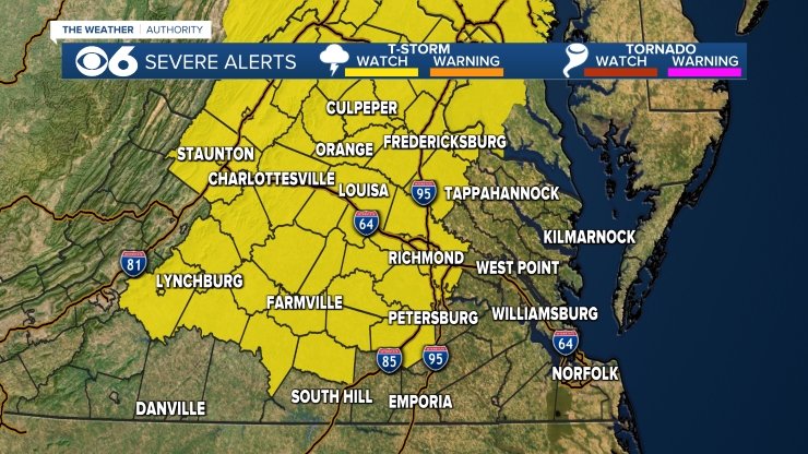
A Severe Thunderstorm Watch is in effect for much of central Virginia (including Metro Richmond) until 10pm. The main threat will be damaging wind gusts up to 65 mph. Stay alert for rapidly changing weather conditions!

A Severe Thunderstorm Watch is in effect for much of central Virginia (including Metro Richmond) until 10pm.  The main threat will be damaging wind gusts up to 65 mph.  Stay alert for rapidly changing weather conditions!
Mike Goldberg (@mikegoldbergwx) 's Twitter Profile Photo

Extremely hot weather on tap for #RVA & central VA the next few days. Be cautious, stay hydrated, check on the elderly & make sure pets are safe from the heat! A heat index of 105-110 in #RVA, with higher numbers up in northern VA. These alerts are for Monday 7/15.

Extremely hot weather on tap for #RVA & central VA the next few days.  Be cautious, stay hydrated, check on the elderly & make sure pets are safe from the heat!  A heat index of 105-110 in #RVA, with higher numbers up in northern VA. These alerts are for Monday 7/15.
Mike Goldberg (@mikegoldbergwx) 's Twitter Profile Photo

A Severe T-storm Watch is in effect for much of central VA, including Metro #RVA until 10pm EDT. Storms developing across the region may produce damaging wind gusts up to 70 mph. Be aware of rapidly changing weather conditions and seek shelter when necessary!

A Severe T-storm Watch is in effect for much of central VA, including Metro #RVA until 10pm EDT.  Storms developing across the region may produce damaging wind gusts up to 70 mph.  Be aware of rapidly changing weather conditions and seek shelter when necessary!
Mike Goldberg (@mikegoldbergwx) 's Twitter Profile Photo

Greetings from the VPM Music studio! I'm so thankful for my wonderful listeners each day & humbled by the nomination for "Best Local Afternoon Radio Show" in the Richmond Times-Dispatch. To support the show, place your vote by clicking on the entertainment category. richmond.com/exclusive/read…

Greetings from the <a href="/myVPM/">VPM</a> Music studio!  I'm so thankful for my wonderful listeners each day &amp; humbled by the nomination for "Best Local Afternoon Radio Show" in the <a href="/RTDNEWS/">Richmond Times-Dispatch</a>.  To support the show, place your vote by clicking on the entertainment category.
richmond.com/exclusive/read…
Mike Goldberg (@mikegoldbergwx) 's Twitter Profile Photo

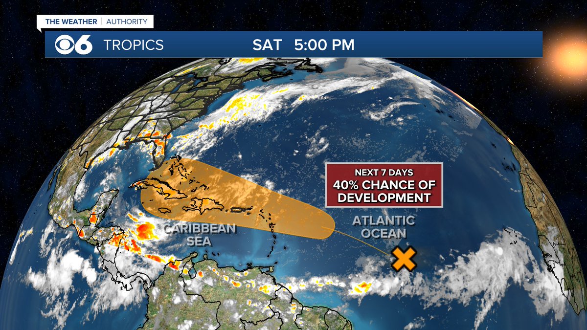
We'll be watching the central Atlantic the next few days, as conditions are forecast to become conducive for some tropical development.

We'll be watching the central Atlantic the next few days, as conditions are forecast to become conducive for some tropical development.
Mike Goldberg (@mikegoldbergwx) 's Twitter Profile Photo

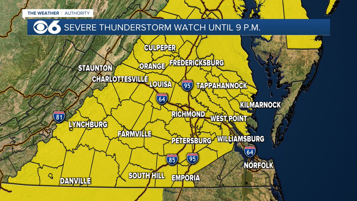
A Severe Thunderstorm Watch is in effect for all of central Virginia until 9PM. Thunderstorms developing across the region will produce torrential rain, frequent light and potential damaging wind gusts up to 70 mph. Be on the lookout for threatening weather conditions! WTVR CBS 6 Richmond
A Severe Thunderstorm Watch is in effect for all of central Virginia until 9PM.  Thunderstorms developing across the region will produce torrential rain, frequent light and potential damaging wind gusts up to 70 mph.  Be on the lookout for threatening weather conditions! <a href="/CBS6/">WTVR CBS 6 Richmond</a>
Mike Goldberg (@mikegoldbergwx) 's Twitter Profile Photo

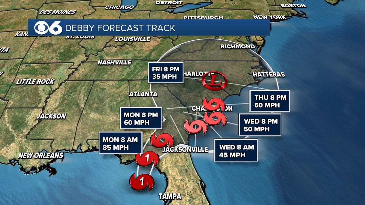
Tropical Storm #Debby is about 260 miles SSW of Tampa, FL with max winds of 45 mph. It's expected to track through the eastern Gulf & reach the Florida Big Bend coast Monday morning, probably as a hurricane. #RVA/central VA may see significant rain later in the week. WTVR CBS 6 Richmond

Tropical Storm #Debby is about 260 miles SSW of Tampa, FL with max winds of 45 mph. It's expected to track through the eastern Gulf &amp; reach the Florida Big Bend coast Monday morning, probably as a hurricane.  
#RVA/central VA may see significant rain later in the week. <a href="/CBS6/">WTVR CBS 6 Richmond</a>
Mike Goldberg (@mikegoldbergwx) 's Twitter Profile Photo

Now Hurricane #Debby has max winds of 75 mph, tracking north & headed for landfall along the Big Bend coast of Florida Monday AM. Torrential rain/flooding expected over the next few days from #FL to coastal #GA & #SC, with heavy rain/flooding a threat in #VA later in the week.

Now Hurricane #Debby has max winds of 75 mph, tracking north &amp; headed for landfall along the Big Bend coast of Florida Monday AM. Torrential rain/flooding expected over the next few days from #FL to coastal #GA &amp; #SC, with heavy rain/flooding a threat in #VA later in the week.
Mike Goldberg (@mikegoldbergwx) 's Twitter Profile Photo

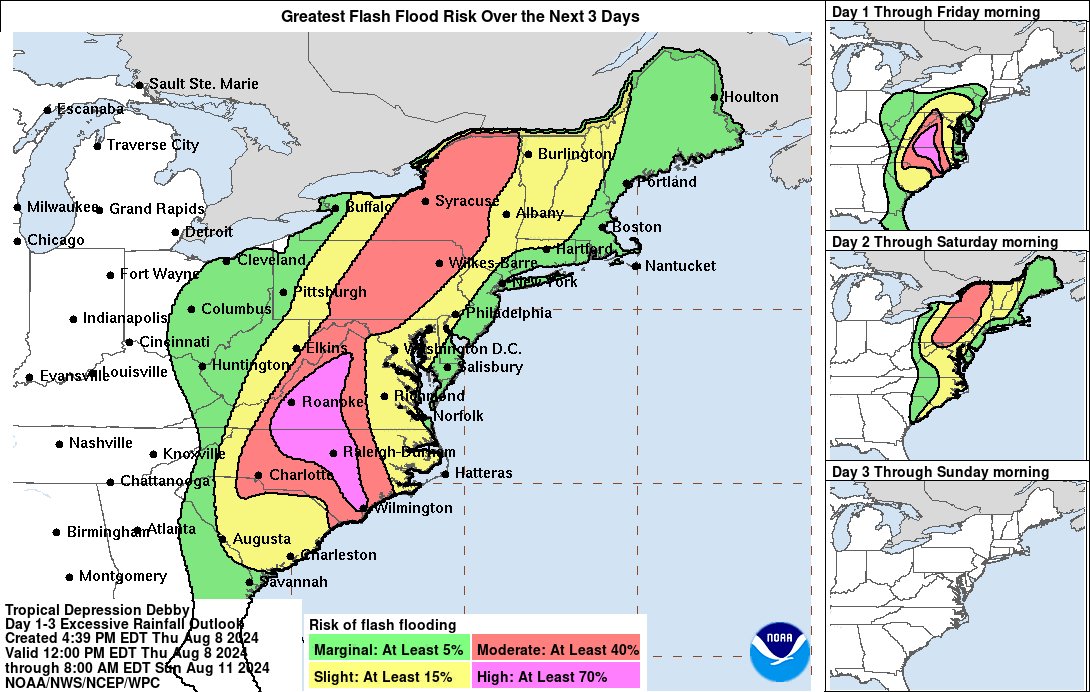
TS #Debby currently has max sustained winds of 60 mph - the center is expected to move across the South Carolina coast Thursday morning, then track thru the Mid-Atlantic. Waves of heavy rain, potential severe weather & flooding all in play for #RVA/central VA Thursday & Friday.

TS #Debby currently has max sustained winds of 60 mph - the center is expected to move across the South Carolina coast Thursday morning, then track thru the Mid-Atlantic. Waves of heavy rain, potential severe weather &amp; flooding all in play for #RVA/central VA Thursday &amp; Friday.
Mike Goldberg (@mikegoldbergwx) 's Twitter Profile Photo

A Tornado Watch is in effect for Metro #RVA & most of central VA until 8pm. A Flood Watch is also in effect through Friday for Metro RVA and all points south & west. The tornado threat will likely continue into the night, so stay weather aware!

A Tornado Watch is in effect for Metro #RVA &amp; most of central VA until 8pm.  A Flood Watch is also in effect through Friday for Metro RVA and all points south &amp; west.  The tornado threat will likely continue into the night, so stay weather aware!
Mike Goldberg (@mikegoldbergwx) 's Twitter Profile Photo

A new Tornado Watch is in effect overnight until 7AM EDT, covering all of central & eastern #VA north to #MD and south to #NC. A flash flood threat remains as well. Stay weather aware and if you have a weather radio, keep it on overnight tonight! WTVR CBS 6 Richmond VPM

A new Tornado Watch is in effect overnight until 7AM EDT, covering all of central &amp; eastern #VA north to #MD and south to #NC. A flash flood threat remains as well.  Stay weather aware and if you have a weather radio, keep it on overnight tonight! <a href="/CBS6/">WTVR CBS 6 Richmond</a> <a href="/myVPM/">VPM</a>
Mike Goldberg (@mikegoldbergwx) 's Twitter Profile Photo

A tropical wave located about midway between the Cabo Verde Islands & the Lesser Antilles is showing signs of organization. A tropical depression is likely to form during the coming week. If it becomes a tropical storm, the next name on the list is Ernesto. WTVR CBS 6 Richmond
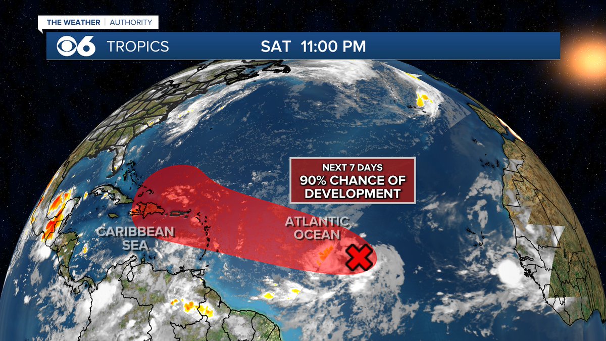
A tropical wave located about midway between the Cabo Verde Islands &amp; the Lesser Antilles is showing signs of organization.  A tropical depression is likely to form during the coming week.  If it becomes a tropical storm, the next name on the list is Ernesto. <a href="/CBS6/">WTVR CBS 6 Richmond</a>
Mike Goldberg (@mikegoldbergwx) 's Twitter Profile Photo

The annual Perseid meteor shower peaks Monday morning, with good viewing conditions expected Sunday night in #RVA between midnight & just before dawn. Try to give yourself a few of the entire sky, get away from city lights & allow your eyes to adjust to the darkness. WTVR CBS 6 Richmond
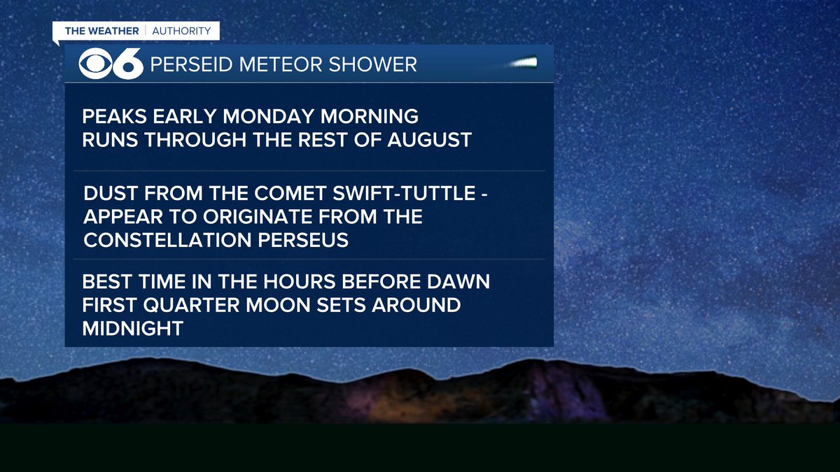
The annual Perseid meteor shower peaks Monday morning, with good viewing conditions expected Sunday night in #RVA between midnight &amp; just before dawn. Try to give yourself a few of the entire sky, get away from city lights &amp; allow your eyes to adjust to the darkness.  <a href="/CBS6/">WTVR CBS 6 Richmond</a>
Mike Goldberg (@mikegoldbergwx) 's Twitter Profile Photo

Potential Tropical Cyclone 5 in the central Atlantic should become Tropical Storm Ernesto by Monday night & potentially a hurricane midweek, passing over the Leeward Islands Tuesday & then likely turning to the right, passing just north of Puerto Rico.

Potential Tropical Cyclone 5 in the central Atlantic should become Tropical Storm Ernesto by Monday night &amp; potentially a hurricane midweek, passing over the Leeward Islands Tuesday &amp; then likely turning to the right, passing just north of Puerto Rico.
Mike Goldberg (@mikegoldbergwx) 's Twitter Profile Photo

The Firehouse Theatre presents "Peter and the Starcatcher," tonight through September 1st. Take a listen to my preview with Producing Artistic Director Nathaniel Shaw during "The Magic of Broadway!" vpm.org/listen/2024-08… Photo: Bill Sigafoos VPM

The <a href="/firehouserva/">Firehouse Theatre</a> presents "Peter and the Starcatcher,"  tonight through September 1st.  Take a listen to my preview with Producing Artistic Director Nathaniel Shaw during "The Magic of Broadway!"  vpm.org/listen/2024-08…  Photo: Bill Sigafoos <a href="/myVPM/">VPM</a>
Mike Goldberg (@mikegoldbergwx) 's Twitter Profile Photo

A Severe T-storm Watch is in effect for all of central Virginia until 10PM. Localized flooding, strong wind gusts & some large hail are all possible. Stay aware of rapidly changing weather conditions! WTVR CBS 6 Richmond
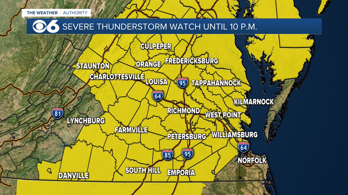
A Severe T-storm Watch is in effect for all of central Virginia until 10PM. Localized flooding, strong wind gusts &amp; some large hail are all possible. Stay aware of rapidly changing weather conditions! <a href="/CBS6/">WTVR CBS 6 Richmond</a>
Mike Goldberg (@mikegoldbergwx) 's Twitter Profile Photo

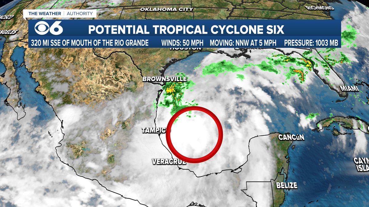
Potential tropical cyclone #6 is in the SW Gulf of Mexico. It doesn't have a well-defined center, but is becoming better organized & should become Tropical Storm Francine. It's forecast to become a hurricane before approaching the Upper Texas/Louisiana coastline Wednesday.

Potential tropical cyclone #6  is in the SW Gulf of Mexico. It doesn't have a well-defined center, but is becoming better organized &amp; should become Tropical Storm Francine. It's forecast to become a hurricane before approaching the Upper Texas/Louisiana coastline Wednesday.
Mike Goldberg (@mikegoldbergwx) 's Twitter Profile Photo

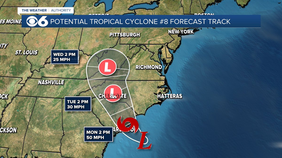
The system off the coast of the Carolinas will likely become Tropical Storm Helene. The center should reach the coast Monday afternoon/evening. Rain is expected to overspread central Virginia by Monday evening, with a shower threat the rest of the week.

The system off the coast of the Carolinas will likely become Tropical Storm Helene.  The center should reach the coast Monday afternoon/evening. Rain is expected to overspread central Virginia by Monday evening, with a shower threat the rest of the week.