Mike (@mike__gagliardi) 's Twitter Profile
Mike

@mike__gagliardi

UB Alum | USwx | Tropical Weather Tracker

ID: 2830988946

calendar_today25-09-2014 03:18:41

5,5K Tweet

1,1K Followers

618 Following

Mitch West (@scweather_wx) 's Twitter Profile Photo

The LLC is pretty much completely exposed now. Very cool view of the storm though. We will see what #Chantal is all about over the next 24 hours.

Mike (@mike__gagliardi) 's Twitter Profile Photo

#Chantal holding steady. She remains lopsided as shear continues to hold all that convection to the east. Shear should dial down near the coast, so she should be able to take advantage of that environment on final approach to SC.

Andrew Austin-Adler (@adler_andrew1) 's Twitter Profile Photo

First recon pass through CHANTAL tonight found winds of 55kt at 850mb. Adopting the standard reduction value of 0.80, this supports 45kt (50mph) surface winds. Additionally, dropsonde data has recorded pressures around 1003mb, so it’s evident the system is strengthening despite

First recon pass through CHANTAL tonight found winds of 55kt at 850mb. Adopting the standard reduction value of 0.80, this supports 45kt (50mph) surface winds. 

Additionally, dropsonde data has recorded pressures around 1003mb, so it’s evident the system is strengthening despite
BGWX (@bradybgwx) 's Twitter Profile Photo

Seems like the upgrade to 50 knots is coming soon. Expect some wind damage along the coast of the Carolinas tonight. Not talking about a strong hurricane by any means but power outages and downed trees and branches are possible. Especially under heaviest rain bands. #ncwx

Seems like the upgrade to 50 knots is coming soon.

Expect some wind damage along the coast of the Carolinas tonight.

Not talking about a strong hurricane by any means but power outages and downed trees and branches are possible.

Especially under heaviest rain bands.

#ncwx
Backpirch Weather (@backpirchcrew) 's Twitter Profile Photo

#Chantal is closing in on landfall over the simmering waters of the Gulf Stream. While shear has thankfully prevented her from coalescing a powerful eyewall, those above-average water temps are still fueling some fairly torrid rainstorms on Chantal’s E side. Inland flooding from

Mike (@mike__gagliardi) 's Twitter Profile Photo

Currently awaiting #Chantal’s inner bands on Pawley’s Island. Just simply looking at radar you can see she’s intensifying, and really kicking things into gear as of late. Gonna be interesting to see how this plays out.

Currently awaiting #Chantal’s inner bands on Pawley’s Island. 

Just simply looking at radar you can see she’s intensifying, and really kicking things into gear as of late.

Gonna be interesting to see how this plays out.
Mike (@mike__gagliardi) 's Twitter Profile Photo

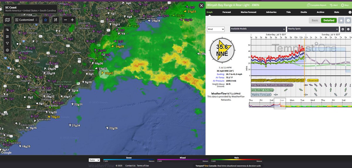
#Chantal is looking increasingly impressive. You can see convection starting to wrap around the northern and NW quadrant of her center, indicating shear is dialing down. Also note her forward motion towards the coast, Myrtle Beach looks in-line for the most intense bands.

Mike (@mike__gagliardi) 's Twitter Profile Photo

Intense outer band here coming ashore Pawley’s Island. Most intense band I’ve encountered yet. Winds gusting over 30 mph. #Chantal

Max Velocity (@maxvelocitywx) 's Twitter Profile Photo

Tropical Storm Chantal is looking very impressive tonight on infrared imagery... Hurricane status is unlikely due to wind shear, but it is trying to intensify before landfall in the Carolinas overnight tonight.

Mike (@mike__gagliardi) 's Twitter Profile Photo

Intense eyewall coming onshore now. Low precip, but still strong sustained winds. Awaiting her ‘eye’ which should be very near this location in Myrtle Beach. #Chantal

Mike (@mike__gagliardi) 's Twitter Profile Photo

#Chantal has officially made landfall just south of my location. It appears Murrells Inlet, SC was her official landfall point.

#Chantal has officially made landfall just south of my location. 

It appears Murrells Inlet, SC was her official landfall point.
Mike (@mike__gagliardi) 's Twitter Profile Photo

As many of you can assume my chase is finalized and I am in for the night. Thank you to all of you for following along! Means so much to see everyone following along, wishing for my safety, and showing interest in mother nature. More to come!