Matthew Ferreira | MassachusettsWx (@massachusettswx) 's Twitter Profile
Matthew Ferreira | MassachusettsWx

@massachusettswx

Battles a brittle bone disease. Passionate with weather, medical and forensic psychology/Criminal Justice. He/him.

ID: 757261153160536064

calendar_today24-07-2016 17:08:22

60,60K Tweet

6,6K Takipçi

280 Takip Edilen

Tropical Cowboy of Danger (@flynonymouswx) 's Twitter Profile Photo

Yeah buoy… dropped a high density pattern with 54 buoys in the path of Hurricane Erin today. It’s a part of of the Sascwatch study on air sea coupling in the storms environment… or something like that. Link below explains it. richterlab.nd.edu/research/sascw…

Matthew Ferreira | MassachusettsWx (@massachusettswx) 's Twitter Profile Photo

I think its possible, similar to 2024, we could see a Gulf of America grown system around the 1st-2 wks of September as the MJO rounds the WHEM.

I think its possible, similar to 2024, we could see a Gulf of America grown system around the 1st-2 wks of September as the MJO rounds the WHEM.
Matthew Ferreira | MassachusettsWx (@massachusettswx) 's Twitter Profile Photo

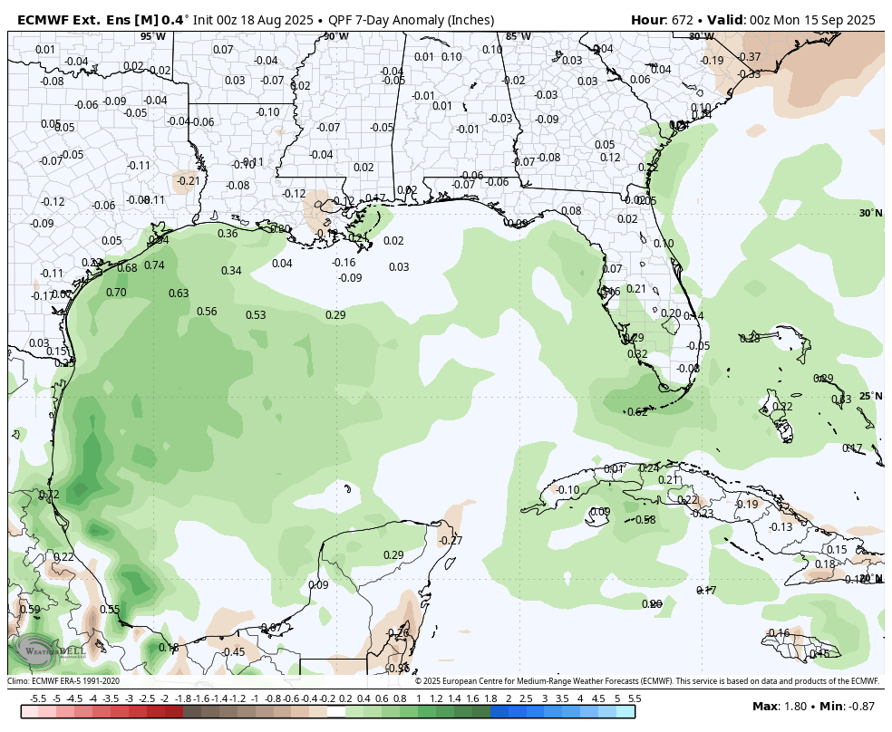
Latest tropical hazard suggest low chances for tropical development over the next 1-3 weeks. Also some chance for the WCAR/BoC to get active as I posted last nights EPS-Ext.

Latest tropical hazard suggest low chances for tropical development over the next 1-3 weeks. Also some chance for the WCAR/BoC to get active as I posted last nights EPS-Ext.
Matthew Ferreira | MassachusettsWx (@massachusettswx) 's Twitter Profile Photo

As we close August and open September, I expect a near or complete basin wide shutdown as dry air takes hold and loss of MJO amplitude occurs. Will have to watch for occasional CCKW's in early-mid Sep for tropical development.

As we close August and open September, I expect a near or complete basin wide shutdown as dry air takes hold and loss of MJO amplitude occurs. Will have to watch for occasional CCKW's in early-mid Sep for tropical development.
The Foliage Report (@foliagereport) 's Twitter Profile Photo

🚨First map of the 2025 Season!🚨 Here is The Foliage Report's latest map for Alaska as of August 20, 2025. As many know, Alaska is the first U.S. state to show fall colors and I can now confirm there is low color showing from northern Alaska's tundra.

🚨First map of the 2025 Season!🚨

Here is The Foliage Report's latest map for Alaska as of August 20, 2025. 

As many know, Alaska is the first U.S. state to show fall colors and I can now confirm there is low color showing from northern Alaska's tundra.
Matthew Ferreira | MassachusettsWx (@massachusettswx) 's Twitter Profile Photo

The windfield with #Erin has exploded in size compared to a week ago today. Fat #Erin starting her NNE turn as it begins to race away from the U.S.

The windfield with #Erin has exploded in size compared to a week ago today. Fat #Erin starting her NNE turn as it begins to race away from the U.S.
Matthew Ferreira | MassachusettsWx (@massachusettswx) 's Twitter Profile Photo

I was able to confirm via a webinar, that the KIMv3.9 will/has been upgraded to KIMv4.0. A major upgrade to horizontal and vertical resolution from 12km to 8km, L50 to L91 is expected along with DA res from 32km to 24km, upgrades to convection, physics, etc

I was able to confirm via a webinar, that the KIMv3.9 will/has been upgraded to KIMv4.0. A major upgrade to horizontal and vertical resolution from 12km to 8km, L50 to L91 is expected along with DA res from 32km to 24km, upgrades to convection, physics, etc
Matthew Ferreira | MassachusettsWx (@massachusettswx) 's Twitter Profile Photo

Waves from Extratropical hurricane #Erin will make a visit to England, Portugal, Spain and the African west coast by Monday. This will be the final indirect impacts from #Erin!

Waves from Extratropical hurricane #Erin will make a visit to England, Portugal, Spain and the African west coast by Monday. This will be the final indirect impacts from #Erin!
Matthew Ferreira | MassachusettsWx (@massachusettswx) 's Twitter Profile Photo

For the first time since mid May, at 12z (8AM tomorrow), the NHEM SPV is expected to peak its eyes open as solar radiation reduces over the Arctic. We're about 5-7d ahead of schedule for the climatological awakening of the NHEM SPV.

For the first time since mid May, at 12z (8AM tomorrow), the NHEM SPV is expected to peak its eyes open as solar radiation reduces over the Arctic. We're about 5-7d ahead of schedule for the climatological awakening of the NHEM SPV.
Matthew Ferreira | MassachusettsWx (@massachusettswx) 's Twitter Profile Photo

As of 5PM, Tropical Storm #Fernand forms in the central tropical Atlantic. Storm is expected to be well out to sea with some rain/gusty winds possible in Bermuda.

As of 5PM, Tropical Storm #Fernand forms in the central tropical Atlantic. Storm is expected to be well out to sea with some rain/gusty winds possible in Bermuda.
Matthew Ferreira | MassachusettsWx (@massachusettswx) 's Twitter Profile Photo

#99L has beat the odds despite models continuously shredding #99L to pieces. It has a small favorable window before it encounters strong trade winds in the Caribbean. It’s then a possibility that development could occur in the western Caribbean or central Gulf of America.

National Weather Service (@nws) 's Twitter Profile Photo

NWS is hiring! Are you interested in working for an agency that uses science and technology to protect lives and property? Additional mission-critical positions just posted on USAJobs.gov, including Meteorologist (1340) openings. Many are great opportunities for

NWS is hiring! Are you interested in working for an agency that uses science and technology to protect lives and property? Additional mission-critical positions just posted on USAJobs.gov, including Meteorologist (1340) openings. Many are great opportunities for
Matthew Ferreira | MassachusettsWx (@massachusettswx) 's Twitter Profile Photo

Model scores for #Fernand are okay but ECMWF leads with lowest track error followed by AVNO then NAVGEM in global modeling. HAFS & COAMPS-TC are best regional performing models.

Model scores for #Fernand are okay but ECMWF leads with lowest track error followed by AVNO then NAVGEM in global modeling. HAFS & COAMPS-TC are best regional performing models.
Matthew Ferreira | MassachusettsWx (@massachusettswx) 's Twitter Profile Photo

Not thinking GFS is right but if it were, we’d have a bad quiet hurricane climatological peak. Thinking activity picks up in the first 2 weeks of September.

Not thinking GFS is right but if it were, we’d have a bad quiet hurricane climatological peak. Thinking activity picks up in the first 2 weeks of September.
Yoshii64 (@yoshii63) 's Twitter Profile Photo

THREAD: The polar vortex has woken up, passing 0 m/s late last week. According to Matthew Ferreira | MassachusettsWx, we are 5-7 days ahead of the climo. date. Colder air from the stratosphere will continue to drop into the troposphere, bringing the needed colder air to the Arctic for blasts.
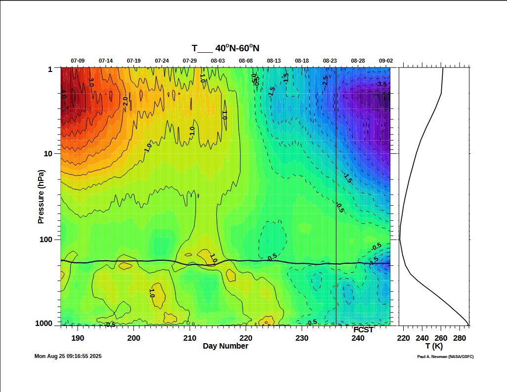
THREAD: The polar vortex has woken up, passing 0 m/s late last week. According to <a href="/MassachusettsWx/">Matthew Ferreira | MassachusettsWx</a>, we are 5-7 days ahead of the climo. date. Colder air from the stratosphere will continue to drop into the troposphere, bringing the needed colder air to the Arctic for blasts.
Matthew Ferreira | MassachusettsWx (@massachusettswx) 's Twitter Profile Photo

It does not surprise me that the GDMI does very well. We saw similar performances to the GraphCast-ECMWF last hurricane season and a Google DeepMind study indicating that Graphcast correctly nailed #Lee 9d out. I did retrospective reviews on GDMI over the past 2 seasons and its

Matthew Ferreira | MassachusettsWx (@massachusettswx) 's Twitter Profile Photo

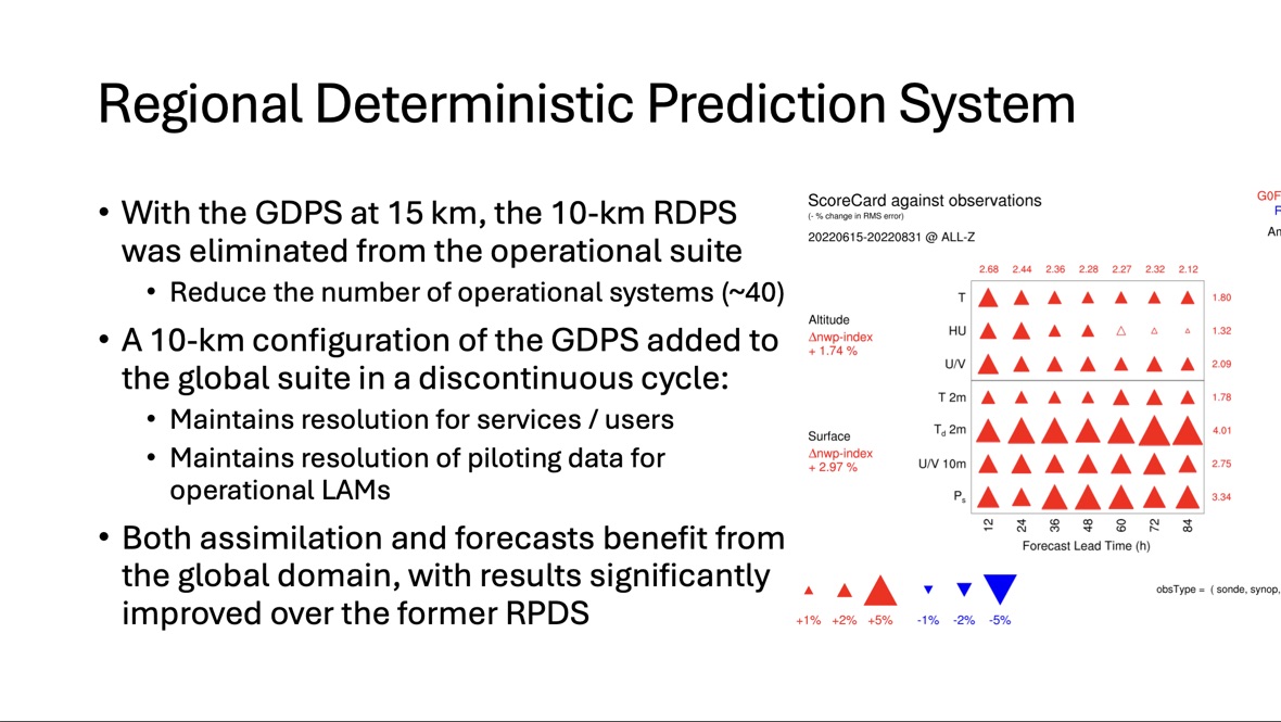
According to this presentation, the RDPS was formally retired in 2024 and an experimental high res version of GDPS was replaced. This change improve model scores by a good bit.

According to this presentation, the RDPS was formally retired in 2024 and an experimental high res version of GDPS was replaced. This change improve model scores by a good bit.