Kentucky Mesonet(@kymesonet) 's Twitter Profileg
Kentucky Mesonet

@kymesonet

The Commonwealth's Official Source for Weather and Climate Data, with 79 automated weather stations across 74 counties in Kentucky.

ID:237454089

linkhttp://www.kymesonet.org calendar_today12-01-2011 21:53:15

5,7K Tweets

2,3K Followers

408 Following

KY Climate Center(@KYClimate) 's Twitter Profile Photo

Zoom link: wku.zoom.us/j/99406376503
YouTube Channel: youtube.com/channel/UCDg3h…

Please let me know if you have any questions, and we look forward to seeing you this Thursday at 2pm ET / 1pm CT!
-KY Climate Center Team NIDIS Drought.gov UK Ag Weather Center

account_circle
KY Climate Center(@KYClimate) 's Twitter Profile Photo

Just click on the Zoom link below (no registration required). There is also the option to view live on the YouTube channel. Webinars are regularly scheduled for the first Thursday of the month, with the opportunity of additional webinars in the case of drought episodes.

account_circle
KY Climate Center(@KYClimate) 's Twitter Profile Photo

We'll take a look at where we stand drought-wise & what the outlooks portend going forward. This webinar is hosted by KY Climate Center in partnership with the National Integrated Drought Information System (NIDIS) and in coordination with the Midwest Drought Early Warning System.

account_circle
KY Climate Center(@KYClimate) 's Twitter Profile Photo

🧵Happy week everyone! A reminder to join us this THU (May 2nd) at 2pm ET / 1pm CT - as state climatologist & WKU Ogden College professor Dr. Jerry Brotzge takes us through a look back at April, current conditions, ag impacts, & outlooks, followed by a time for Q & A.

🧵Happy #KentuckyDerby150 week everyone! A reminder to join us this THU (May 2nd) at 2pm ET / 1pm CT - as state climatologist & @wkuogden professor Dr. Jerry Brotzge takes us through a look back at April, current conditions, ag impacts, & outlooks, followed by a time for Q & A.
account_circle
Kentucky Mesonet(@kymesonet) 's Twitter Profile Photo

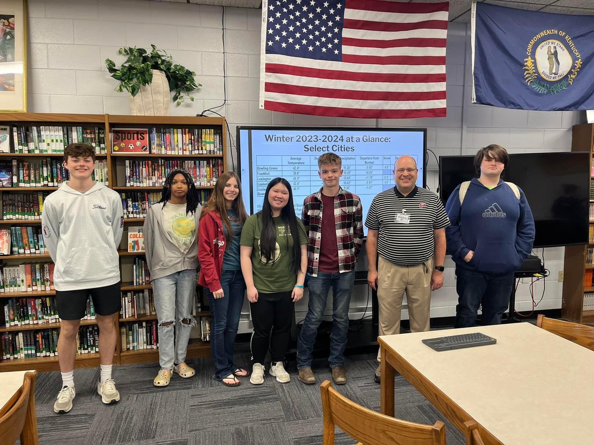
On Friday, we paid a visit to Butler County High School in Morgantown, KY, where we spoke to environmental science students along with the STEM Club on Mesonet, climate, along with careers in meteorology. Or thanks to Ms. Madison Staton for having us!

On Friday, we paid a visit to Butler County High School in Morgantown, KY, where we spoke to environmental science students along with the STEM Club on Mesonet, climate, along with careers in meteorology. Or thanks to Ms. Madison Staton for having us! #outreach #kywx
account_circle
Kentucky Mesonet(@kymesonet) 's Twitter Profile Photo

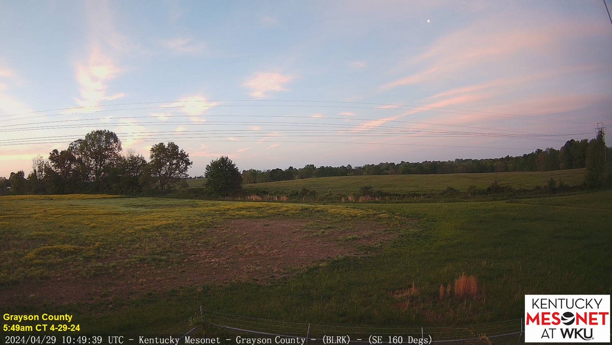
High clouds appeared like cotton candy in the skies over the Commonwealth on what is the start of week! 👀at the waning gibbous moon 🌖from our shot facing SE in Grayson Co. near Leitchfield! Expect clouds to thicken today with rain on the approach.

High clouds appeared like cotton candy in the skies over the Commonwealth on what is the start of #KentuckyDerby150 week! 👀at the waning gibbous moon 🌖from our shot facing SE in Grayson Co. near Leitchfield! Expect clouds to thicken today with rain on the approach. #kywx
account_circle
Kentucky Mesonet(@kymesonet) 's Twitter Profile Photo

On Wednesday, we had an opportunity to present about Mesonet and climate along with weather's ties to agriculture and horiculture at Warren East High School (Warren East High) in Bowling Green. Our thanks to Ms. Keeling for the invite to speak to the high schoolers!

On Wednesday, we had an opportunity to present about Mesonet and climate along with weather's ties to agriculture and horiculture at @WEHSRaiders (Warren East High) in Bowling Green. Our thanks to Ms. Keeling for the invite to speak to the high schoolers! #outreach #kywx
account_circle
KY Climate Center(@KYClimate) 's Twitter Profile Photo

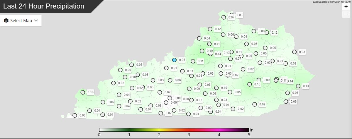
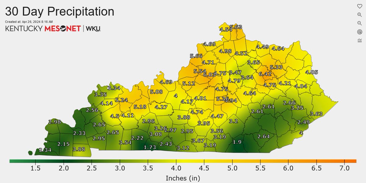
We're tracking a band of light to moderate rain advancing E through portions of west/central KY this morning. Some of this region could really use this rainfall. A number of sites in the Pennyrile area and along the TN line have seen < 3' of rain in the past 30 days.

We're tracking a band of light to moderate rain advancing E through portions of west/central KY this morning. Some of this region could really use this rainfall. A number of sites in the Pennyrile area and along the TN line have seen < 3' of rain in the past 30 days. #kywx
account_circle
Molly Woloszyn(@ClimateMolly) 's Twitter Profile Photo

However, for areas that receive below-normal precipitation in the coming months, these areas may be at risk for worsening drought conditions due to increased evaporative demand from higher temperatures and a lack of subsoil moisture. (5/5)

account_circle
Molly Woloszyn(@ClimateMolly) 's Twitter Profile Photo

If the current wetter pattern continues and the region receives regular and frequent precipitation, drought conditions will likely improve in some areas. (4/5)

account_circle
Molly Woloszyn(@ClimateMolly) 's Twitter Profile Photo

New Status Update for the US (1/5).

The short-term drought improvements over the winter and spring doesn't mean we're out of the woods. Many areas across Midwest have 4-year precipitation deficits of 20+ inches.

Read more: drought.gov/drought-status…

New #Drought Status Update for the #Midwest US (1/5). The short-term drought improvements over the winter and spring doesn't mean we're out of the woods. Many areas across Midwest have 4-year precipitation deficits of 20+ inches. Read more: drought.gov/drought-status…
account_circle
Kentucky Mesonet(@kymesonet) 's Twitter Profile Photo

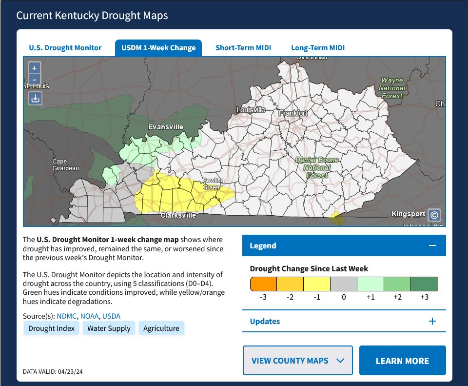
Thu morning update from NIDIS Drought.gov continues to show a small part of W KY near Paducah in D1 (Mod Drought) conditions. While NW KY was removed from D0 (abnormally dry) conditions, parts of the Pennyrile region E to Bowling Green/Glasgow show a degradation to D0 this week.

Thu morning update from @NOAADrought continues to show a small part of W KY near Paducah in D1 (Mod Drought) conditions. While NW KY was removed from D0 (abnormally dry) conditions, parts of the Pennyrile region E to Bowling Green/Glasgow show a degradation to D0 this week. #kywx
account_circle
Kentucky Mesonet(@kymesonet) 's Twitter Profile Photo

For the first time in a long time, we have webcam imagery from our tower in S Pike County in eastern KY! What a gorgeous view of the mountains near the VA border.📷

For the first time in a long time, we have webcam imagery from our tower in S Pike County in eastern KY! What a gorgeous view of the mountains near the VA border.📷#kywx
account_circle
KY Climate Center(@KYClimate) 's Twitter Profile Photo

Did Monday's frost (and freeze, for some) cause damage to the Kentucky's wheat crop? This article has more: kygrains.info/blog/2024/4/23… UK Ag Weather Center

account_circle
Kentucky Mesonet(@kymesonet) 's Twitter Profile Photo

Does this creepy-crawlie give you the heeby jeebies? Our field technicians found this little guy earlier at our site in southern Pike County!

Does this creepy-crawlie give you the heeby jeebies? Our field technicians found this little guy earlier at our site in southern Pike County! #alongcameaspider #kywx
account_circle
Kentucky Mesonet(@kymesonet) 's Twitter Profile Photo

NEW: Real-time webcams (updating every 5 mins) have been installed at our sites in Butler, Clinton, & Clark Cos. Each camera features much broader views of the landscapes surrounding them. These & all webcams can be viewed on kymesonet.org or via the Mesonet app!

NEW: Real-time webcams (updating every 5 mins) have been installed at our sites in Butler, Clinton, & Clark Cos. Each camera features much broader views of the landscapes surrounding them. These & all webcams can be viewed on kymesonet.org or via the Mesonet app! #kywx
account_circle
Kentucky Mesonet(@kymesonet) 's Twitter Profile Photo

This morning's and (for some) freezing temperatures seems to have temporarily cooled the top soil a bit, but the three-day average 4' depth temperatures are now running in the 60s for most of the Commonwealth.

This morning's #frost and (for some) freezing temperatures seems to have temporarily cooled the top soil a bit, but the three-day average 4' depth temperatures are now running in the 60s for most of the Commonwealth. #kywx
account_circle
Kentucky Mesonet(@kymesonet) 's Twitter Profile Photo

From our 'Critter Corner', as seen by field technician Andrew Lowe at our Adair Co. site Friday.

What can we say? It's that time of year again...

account_circle
Kentucky Mesonet(@kymesonet) 's Twitter Profile Photo

Brrr! 🥶Most of the state is under a Frost Advisory until mid-morning, and sure enough, we're waking up to widespread in many cases. A few lows even dipped into 'hard freeze' territory (28 or colder).
Do you have frost where you live this morning?

Brrr! 🥶Most of the state is under a Frost Advisory until mid-morning, and sure enough, we're waking up to widespread #frost in many cases. A few lows even dipped into 'hard freeze' territory (28 or colder). Do you have frost where you live this morning? #kywx
account_circle