Geography of Kenya
@kenyangeography
Exploring Kenya's geography ▶
A showcase of the country's geographical features and how they shape lives ▶
YouTube ⬇️ youtube.com/@kenyangeograp…
ID: 1203284817212825609
07-12-2019 12:08:34
4,4K Tweet
34,34K Followers
211 Following
 's Twitter Profile Photo")
 on Twitter photo The Lamu archipelago is a series of islands in Lamu County. These historic islands like Manda, Pate, Siyu & Lamu thrived in the middle ages as part of the Indian Ocean trade.
Seasonal winds allowed ships to call on these islands with deep natural harbours, making them trade hubs")
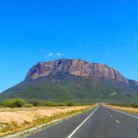
 on Twitter photo Taita Hills is part of the ancient Eastern Arc mountains in EA.
The geographic isolation and age has made the hills a biodiversity hotspot, with flora and fauna not found anywhere else. In the last 200 years, the hills have lost more than 90% of the trees from human activity.")
 on Twitter photo Lake Chala is a crater lake along the Kenya-TZ border in Taita Taveta County. The deep, fresh water lake inside a hill, is fed by subterranean flows from Mt. Kilimanjaro. The water flows out of the crater to further feed Lake Jipe nearby.
#County006")
 on Twitter photo Mt. Kinangop towers over the skyline of Nairobi in this zoomed photo of the capital.
Nairobi is located on highlands near the Rift valley escarpment. Mt. Kinangop is in the southern section of Nyandarua range. The range forms part of the Eastern escarpment of the Rift valley.")
 on Twitter photo The central section of the Rift valley is the highest in Kenya. Volcanic activity in the mantle and crust caused a thermal plume that uplifted the land causing the formation of the Rift valley.
A short thread on the Central Rift valley in Kenya.
🧵")
 on Twitter photo There's clear skies over most of Kenya in September, making for great views of distant mountains. From the elevated highlands of South Nyandarua at 'Flyover', one can view both Nyandarua range (Aberdares) and Mt. Kenya (spot it? 👀)
Share your distant sightings of Mt. Kenya 👇🏽")
 on Twitter photo Mathioya river flows East across Muranga county, trickling down from the slopes of Nyandarua range to join Tana river near Makutano junction.
Mathioya is one of numerous tributaries of Tana river flowing from Nyandarua. They join Sagana river at different points near A2 highway.")