Kaleb (@kaleb1137451) 's Twitter Profile
Kaleb

@kaleb1137451

ID: 1931051243763572738

calendar_today06-06-2025 18:11:27

586 Tweet

109 Followers

1,1K Following

Andrew Shearer (@drewshearer444) 's Twitter Profile Photo

6/ In short, a lot of uncertainty remains on the exact track of #Erin at this time and will likely continue in the near term. Hurricane recon data will significantly help our forecasts of Erin, but residents along the East Coast and in Bermuda should monitor the NHC forecasts.

6/ In short, a lot of uncertainty remains on the exact track of #Erin at this time and will likely continue in the near term. Hurricane recon data will significantly help our forecasts of Erin, but residents along the East Coast and in Bermuda should monitor the NHC forecasts.
Ryan Hall, Y’all (@ryanhallyall) 's Twitter Profile Photo

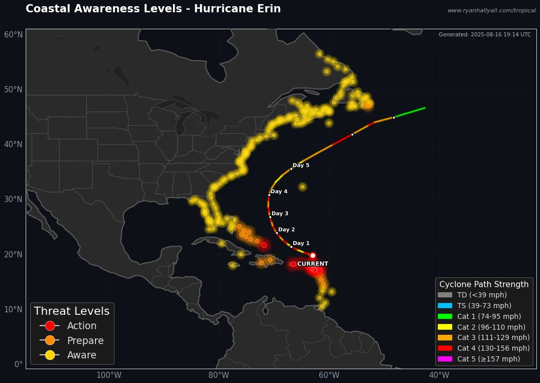
Hurricane #Erin has trended west but remains well offshore of the US East Coast. FL to MA: Stay AWARE but no need for alarm - storm will pass 350+ miles offshore. 🚨 Turks & Caicos - take action now, at least tropical storm impacts expected soon. ⚠️ Eleuthera & Newfoundland -

Hurricane #Erin has trended west but remains well offshore of the US East Coast. FL to MA: Stay AWARE but no need for alarm - storm will pass 350+ miles offshore.

🚨 Turks & Caicos - take action now, at least tropical storm impacts expected soon. 
⚠️ Eleuthera & Newfoundland -
Dylan Federico (@dylanfedericowx) 's Twitter Profile Photo

Hurricane #Erin is forecast to generate 100 foot waves in the southwest Atlantic this week! Erin’s mammoth wind field will bring massive swells and a major rip current risk to the US East Coast even though it’s forecast to pass well offshore. #TropicalUpdate 🌀🤯

Hurricane #Erin is forecast to generate 100 foot waves in the southwest Atlantic this week! 

Erin’s mammoth wind field will bring massive swells and a major rip current risk to the US East Coast even though it’s forecast to pass well offshore.

#TropicalUpdate 🌀🤯
FOX Weather (@foxweather) 's Twitter Profile Photo

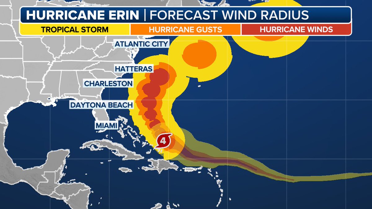
ONE TO WATCH: With Hurricane Erin churning across the Atlantic near the northern Caribbean islands, forecasters with the National Hurricane Center tagged a new area to watch across the Main Development Region in the central tropical Atlantic. foxweather.com/weather-news/a…

Mike's Weather Page (@tropicalupdate) 's Twitter Profile Photo

Latest EURO wave map for Erin. Storm expected to expand and get much wider. Some big waves will be reaching most of the east coast this week. Check out where the center will be. 100+ foot plus waves! Pretty sure we won't see any cruise lines near that. spaghettimodels.com

Latest EURO wave map for Erin. Storm expected to expand and get much wider. Some big waves will be reaching most of the east coast this week. Check out where the center will be. 100+ foot plus waves! Pretty sure we won't see any cruise lines near that. spaghettimodels.com
Michael Ferragamo (@ferragamowx) 's Twitter Profile Photo

#ERIN strengthens further to 120 kts (140 mph). Its wind field is already more than double the size of what it was during its Category 5 peak, and will only grow more as it gains latitude.

Ian Oliver (@ianoliverwx) 's Twitter Profile Photo

There are still considerable & dangerous fringe impacts from major hurricane Erin expected - no question. But man - it's amazing to watch a storm this intense with its huge growing wind field buzz the tower across so many different locations near the Caribbean & points north

There are still considerable & dangerous fringe impacts from major hurricane Erin expected - no question.

But man - it's amazing to watch a storm this intense with its huge growing wind field buzz the tower across so many different locations near the Caribbean & points north
Michael Ferragamo (@ferragamowx) 's Twitter Profile Photo

The amount of people who think #ERIN is still going to hit the US is concerning. Here is the latest EURO vs the EURO over 6 days ago. There has never been a general solution of a US landfall — it’s always been between the US and Bermuda.

Andrew Shearer (@drewshearer444) 's Twitter Profile Photo

An interesting feature you can see on satellite is the outward propagating waves from #Erin's center. Some research I have seen others working on, which examines the speed at which these waves propagate, may be related to the intensity trend of a TC. Something cool to see!

OldFoundWeatherNerd (@notchilledout) 's Twitter Profile Photo

I want to remind everyone that despite mainly traversing water; the 5/24/11 Canton Lake EF3 was just as intense as the other tornadoes on that day. Mangling a vintage truck w/ a steal body; creating a mini seiche on Canton Lake; and doing violent tree damage. This EF3 was violent

I want to remind everyone that despite mainly traversing water; the 5/24/11 Canton Lake EF3 was just as intense as the other tornadoes on that day. Mangling a vintage truck w/ a steal body; creating a mini seiche on Canton Lake; and doing violent tree damage.
This EF3 was violent
National Weather Service (@nws) 's Twitter Profile Photo

A large portion of the Atlantic coastline will see the risk for high surf and rip currents increase this week due to #Erin. 🟥Risk of Rip Currents is High🟥 Life-threatening rip currents are likely. Swimming conditions are unsafe for all levels of swimmers. Stay out of the

A large portion of the Atlantic coastline will see the risk for high surf and rip currents increase this week due to #Erin. 

🟥Risk of Rip Currents is High🟥
Life-threatening rip currents are likely. Swimming conditions are unsafe for all levels of swimmers. Stay out of the
Michael Ferragamo (@ferragamowx) 's Twitter Profile Photo

Massive Hurricane #ERIN holding steady in intensity this afternoon. It’ll continue to move north through a weakness in the ridge before encountering some shear. Big swells coming for the US east coast and Bermuda — wouldn’t be surprised to see storm surge watches soon for the NC

Jeremy Perez (@jperez1690) 's Twitter Profile Photo

Storms got stingy with CGs after crossing the Bradshaws Friday night. Just enough IC flashes to keep one hopeful. Looking west over Dewey as the gust front moved in. #azwx

Storms got stingy with CGs after crossing the Bradshaws Friday night. Just enough IC flashes to keep one hopeful. Looking west over Dewey as the gust front moved in.
#azwx
Jen Carfagno (@jencarfagno) 's Twitter Profile Photo

Hurricane Erin will track in between the US East coast and Bermuda. But it is “unusually large” - and its big ocean footprint will drive up the waves on the east coast. I’ll be live America’s Morning Headquarters and on Weather Unfiltered Tuesday from the Outer Banks, NC.
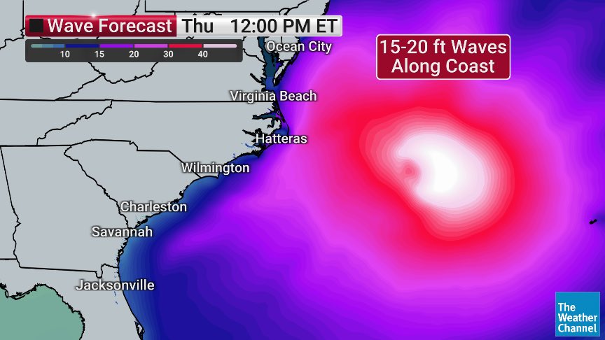
Hurricane Erin will track in between the US East coast and Bermuda. But it is “unusually large” - and its big ocean footprint will drive up the waves on the east coast.   I’ll be live <a href="/AMHQ/">America’s Morning Headquarters</a> and on <a href="/wxunfiltered/">Weather Unfiltered</a> Tuesday from the Outer Banks, NC.