J🛰seph Patton (@josephpattonwx) 's Twitter Profile
J🛰seph Patton

@josephpattonwx

lightning researcher at UMD/ESSIC/CISESS. former NWS met. 'GLM evangelist.' FRQ LTG ALQDS. Louisiana born, raised & frequently. tweets do not represent any orgs

ID: 730157388855169024

linkhttp://weatheracademy.org calendar_today10-05-2016 22:07:41

24,24K Tweet

3,3K Takipçi

2,2K Takip Edilen

J🛰seph Patton (@josephpattonwx) 's Twitter Profile Photo

telling my family in Ft. Smith Arkansas to get to their tornado shelter spot for now. hope everybody is okay from the night's severe weather

IEMBot GLD (@iembot_gld) 's Twitter Profile Photo

GLD issues Damage Survey PNS (Max: EF3) at May 19, 8:44 PM MDT ...NWS Damage Survey for 05/18/2025 Tornado Event... mesonet.agron.iastate.edu/p.php?pid=2025…

J🛰seph Patton (@josephpattonwx) 's Twitter Profile Photo

welp. not the greatest time for SPC's mesoanalysis page to make blank surface observation maps for the SE sector (other sectors seem fine though)

welp. not the greatest time for SPC's mesoanalysis page to make blank surface observation maps for the SE sector (other sectors seem fine though)
wxKobold (@wxkobold) 's Twitter Profile Photo

I'm so excited about this! I caught video of a lightning bolt that was ALSO scanned by radar and detected by GLM. This is only the second time I've managed to match up video/photo and radar, and it's my own video! So stoked. Not the best example of either, but hey it's a match!

Steve Caparotta, Ph.D. (@stevewafb) 's Twitter Profile Photo

JUST IN: NOAA forecasts a 60% chance of an above average hurricane season. 13-19 Named Storms 6-10 Hurricanes 3-5 Major Hurricanes

JUST IN: NOAA forecasts a 60% chance of an above average hurricane season. 

13-19 Named Storms
6-10 Hurricanes
3-5 Major Hurricanes
J🛰seph Patton (@josephpattonwx) 's Twitter Profile Photo

are the 2025 Indiana Pacers the most underrated NBA team of all time? to go up 2-0 on the road against the 2 presumptive favorites to make it out of the Eastern Conference back to back is insane

J🛰seph Patton (@josephpattonwx) 's Twitter Profile Photo

can confirm some dangerous street and stream flooding around an hour ago in the vicinity of US 29 and MD 32. Old Columbia Road was nearly impassable with 6 to 8 inches of water rushing over the roadway near the Middle Patuxent River #MDwx NWS Baltimore-Washington trained spotter #: AX177

J🛰seph Patton (@josephpattonwx) 's Twitter Profile Photo

please don't do this University System of Maryland. AccuWeather did not issue the tornado warning. by law, that's not their authority. the NWS issued the tornado warning, and you choose to pay AccuWeather to tell you when those warnings are issued. it is not the same thing
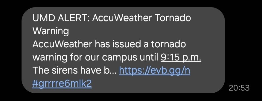

please don't do this <a href="/Univ_System_MD/">University System of Maryland</a>. AccuWeather did not issue the tornado warning. by law, that's not their authority. the NWS issued the tornado warning, and you choose to pay AccuWeather to tell you when those warnings are issued. it is not the same thing
UW-Madison CIMSS (@uwcimss) 's Twitter Profile Photo

True Color RGB images from #GOES19/#GOESEast showed the Canadian wildfire smoke was particularly dense over parts of North Dakota & South Dakota...

madelynn brook⚡️ (@madelynn_wx) 's Twitter Profile Photo

taking my last obv at KCLT for awhile, watching storms develop like this from the roof is a view I’m gonna miss. ‘til next time charlotte 🫡