Joey Sovine Live 5 (@joeysovine) 's Twitter Profile
Joey Sovine Live 5

@joeysovine

AMS Certified Broadcast Meteorologist. Morning/Noon weather on @Live5News in Charleston, SC. Cleveland/Virginia Tech sports guy! Chanel’s husband, dad of 2.

ID: 16117189

linkhttp://www.live5news.com calendar_today03-09-2008 18:36:43

30,30K Tweet

5,5K Followers

1,1K Following

Meteorologist Dorien Minor (@minorwx) 's Twitter Profile Photo

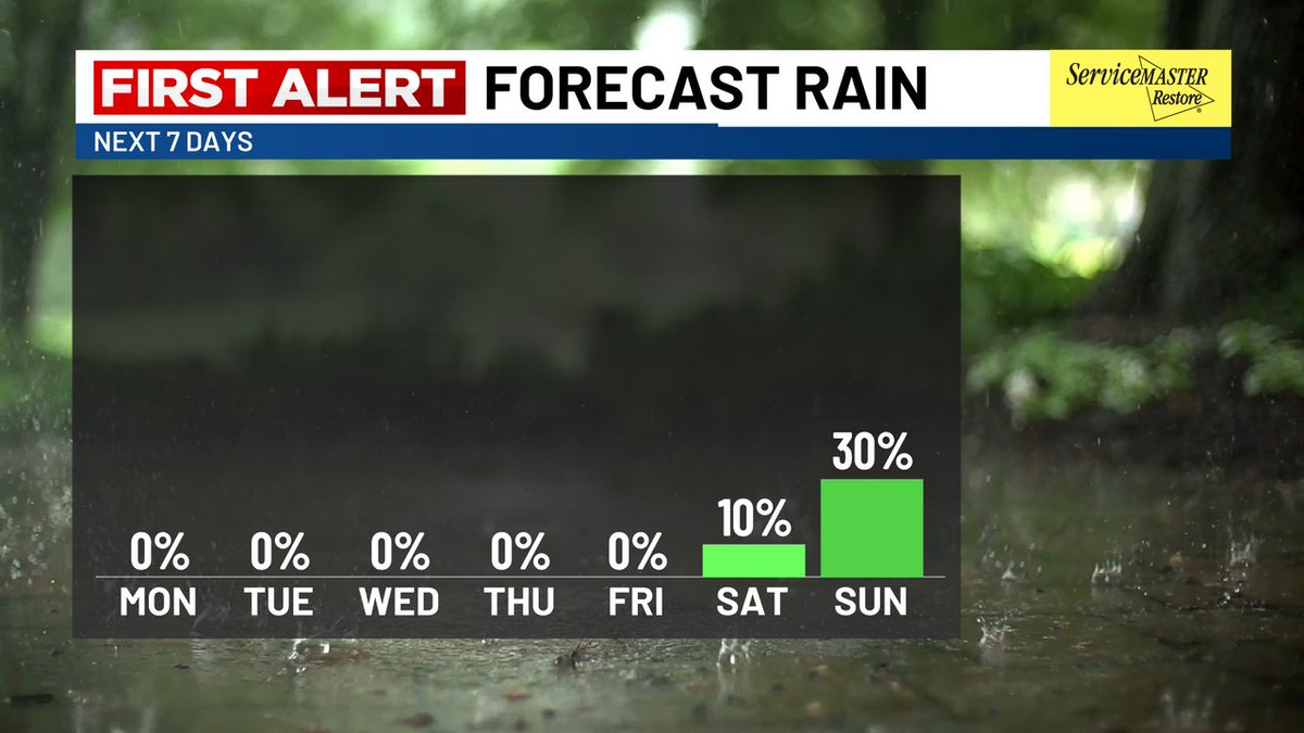
FUTURE TRACKER: A sunshine-filled Saturday will give way to our next chance of rain on Sunday! As a weak cold front passes through the Lowcountry, Sunday should start with an increase in clouds; a few brief showers cannot be ruled out Sunday evening or early Sunday night. #SCWX

Meteorologist Dorien Minor (@minorwx) 's Twitter Profile Photo

TROPICS: National Hurricane Center has classified a tropical wave in the Central Atlantic as Invest #98L as of Saturday afternoon! Trends will be watched closely for potential tropical development as the environment becomes more conducive in the Caribbean Sea later next week. #Tropics #AL98

TROPICS: <a href="/NHC_Atlantic/">National Hurricane Center</a> has classified a tropical wave in the Central Atlantic as Invest #98L as of Saturday afternoon! Trends will be watched closely for potential tropical development as the environment becomes more conducive in the Caribbean Sea later next week. #Tropics #AL98
Meteorologist Dorien Minor (@minorwx) 's Twitter Profile Photo

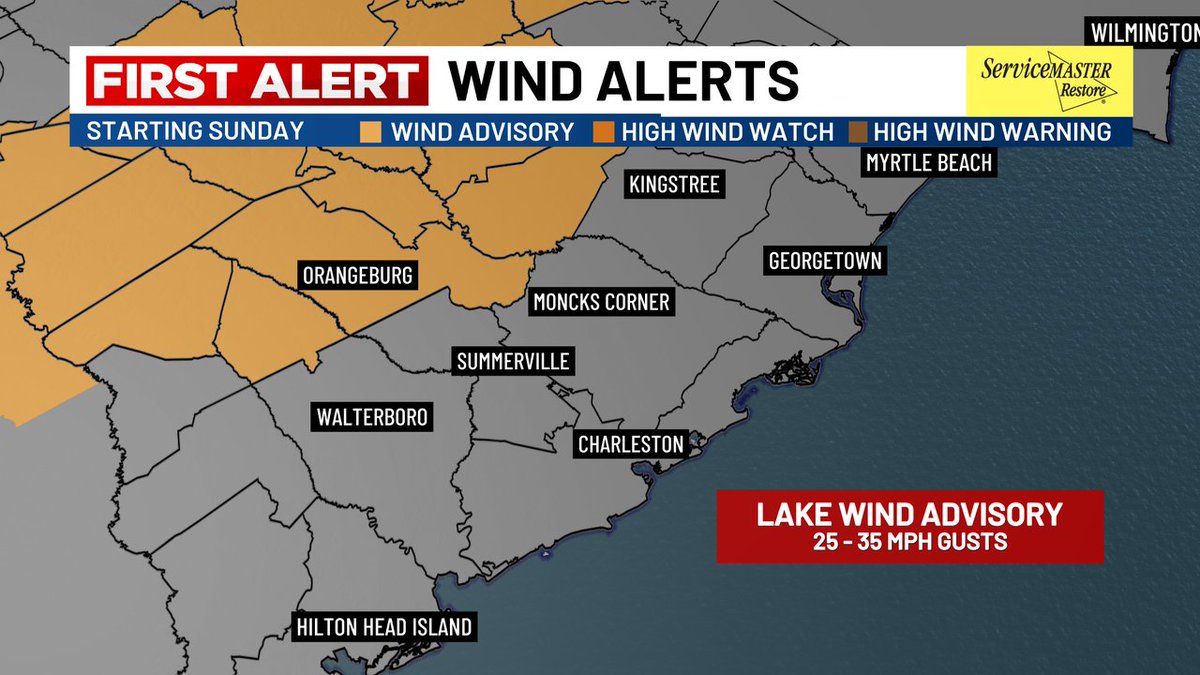
FIRST ALERT: Winds will increase ahead of Sunday evening's front - perhaps to between 25-35 MPH at times! A "Lake Wind Advisory" has been issued for Orangeburg and Clarendon Counties where such winds could linger around into early Monday morning. #SCWX #CHSWX

FIRST ALERT: Winds will increase ahead of Sunday evening's front - perhaps to between 25-35 MPH at times! A "Lake Wind Advisory" has been issued for Orangeburg and Clarendon Counties where such winds could linger around into early Monday morning. #SCWX #CHSWX
Meteorologist Dorien Minor (@minorwx) 's Twitter Profile Photo

FIRST ALERT (4:30 PM) - Tonight's cold front has entered the Upstate... but we're still not seeing much in terms of moisture! More clouds - and perhaps a stray shower or two - will move through the Lowcountry during the evening hours before moving offshore later tonight. #SCWX

Meteorologist Dorien Minor (@minorwx) 's Twitter Profile Photo

TROPICS: Per National Hurricane Center, there is now a "high" likelihood for tropical development this week as Invest #98L moves into the Caribbean Sea! As organization occurs in the coming days, uncertainty still remains high in the eventual path of such a system. #Tropics #AL98
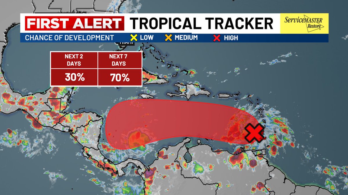
TROPICS: Per <a href="/NHC_Atlantic/">National Hurricane Center</a>, there is now a "high" likelihood for tropical development this week as Invest #98L moves into the Caribbean Sea! As organization occurs in the coming days, uncertainty still remains high in the eventual path of such a system. #Tropics #AL98
Meteorologist Dorien Minor (@minorwx) 's Twitter Profile Photo

THIS WEEK: DRY In addition to tonight's cold front, our next front on Tuesday will move through without much fanfare! Only a small rain chance exists next weekend into early next week. Until then, we'll enjoy plenty of sunshine and cooler-than-average temperatures! #SCWX

THIS WEEK: DRY

In addition to tonight's cold front, our next front on Tuesday will move through without much fanfare! Only a small rain chance exists next weekend into early next week. Until then, we'll enjoy plenty of sunshine and cooler-than-average temperatures! #SCWX
Bill Walsh (@billwalshtv) 's Twitter Profile Photo

FIRST ALERT// Tropical Storm Melissa // This storm is not too well organized and forecast to move west to northwest over the next few days. It is forecast to become a hurricane, but the models differ in the future path. No threat at this time and we will continue to monitor.

Bill Walsh (@billwalshtv) 's Twitter Profile Photo

FIRST ALERT// Tropical Storm Melissa Update// Melissa is still a tropical storm and slow to organize thanks to wind shear. The storm is forecast to become a hurricane by the weekend but will slow to a crawl bringing heavy rains to parts of the Caribbean. No threat at this time.

Meteorologist Dorien Minor (@minorwx) 's Twitter Profile Photo

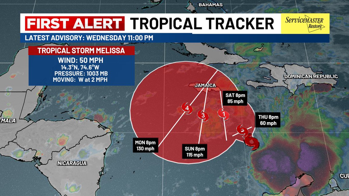
TROPICS: The future intensity of Tropical Storm Melissa is trending higher as it drifts into a highly favorable environment in the Western Caribbean Sea! As of Wednesday evening, #Melissa remains a sheared system, but better organization is likely to occur by late week. #Tropics

TROPICS: The future intensity of Tropical Storm Melissa is trending higher as it drifts into a highly favorable environment in the Western Caribbean Sea! As of Wednesday evening, #Melissa remains a sheared system, but better organization is likely to occur by late week. #Tropics
Meteorologist Dorien Minor (@minorwx) 's Twitter Profile Photo

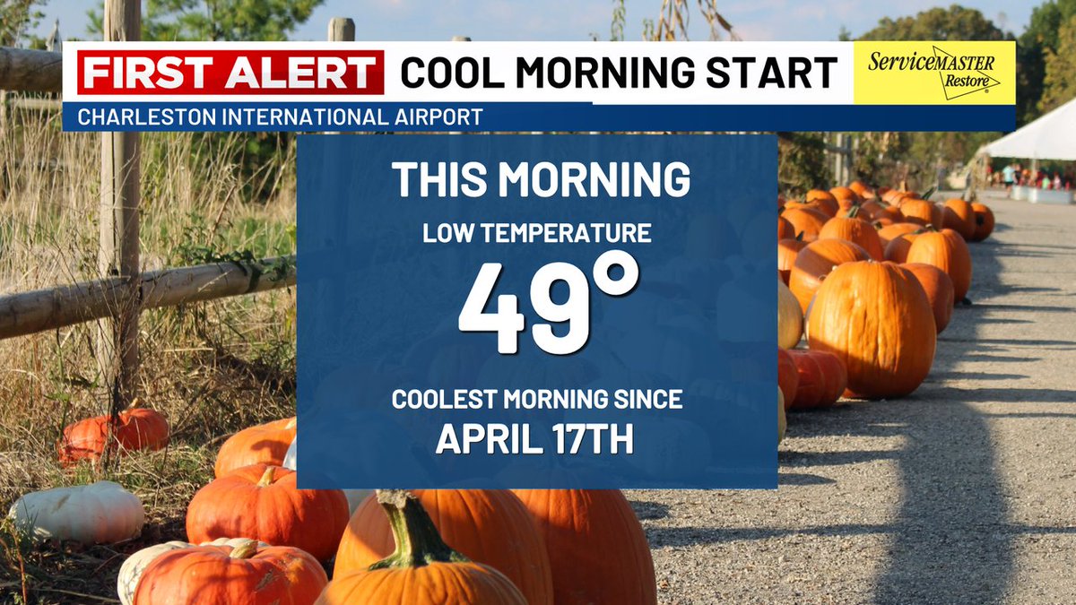
FUTURE TRACKER: Wednesday morning offered a brief break from our stretch of chilly morning temperatures... but we're on track to return to the 40s tonight! Our typical cold spots (Williamsburg County and areas closer to I-95) may dip into the low and mid 40s. #SCWX #CHSWX

Meteorologist Dorien Minor (@minorwx) 's Twitter Profile Photo

TROPICS: Wind shear has not relaxed around #Melissa just yet! Forecast models are in agreement on a period of quick strengthening as soon as this weekend. Impacts from wind and flooding are increasingly likely for parts of the Greater Antilles into next week. #Tropics #Jamaica

TROPICS: Wind shear has not relaxed around #Melissa just yet! Forecast models are in agreement on a period of quick strengthening as soon as this weekend. Impacts from wind and flooding are increasingly likely for parts of the Greater Antilles into next week. #Tropics #Jamaica
Bill Walsh (@billwalshtv) 's Twitter Profile Photo

FIRST ALERT// Tropical Update // Tropical Storm Melissa is forecast to become a hurricane and possibly a category 4 hurricane in the Caribbean. Models keep the storm moving slow, but future tracks may take it north to northeast. No threat at this time.

FIRST ALERT// Tropical Update // Tropical Storm Melissa is forecast to become a hurricane and possibly a category 4 hurricane in the Caribbean.  Models keep the storm moving slow, but future tracks may take it north to northeast.  No threat at this time.
Bill Walsh (@billwalshtv) 's Twitter Profile Photo

FIRST ALERT// Tropical Update //Tracking Tropical Storm Melissa over the Caribbean. Forecast track is slow but does bring the storm to hurricane strength and possibly, major hurricane by Monday & Tuesday. No threat at this time. Models seem to be focusing on a future turn North.

Meteorologist Dorien Minor (@minorwx) 's Twitter Profile Photo

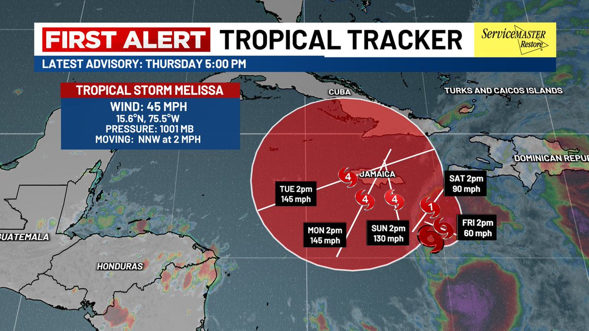
TROPICS: Tropical Storm #Melissa has weakened slightly as of Thursday evening in response to strong wind shear! Conditions will become more favorable for quick development by this weekend, which may exacerbate impacts for portions of the Greater Antilles and Jamaica. #Tropics

TROPICS: Tropical Storm #Melissa has weakened slightly as of Thursday evening in response to strong wind shear! Conditions will become more favorable for quick development by this weekend, which may exacerbate impacts for portions of the Greater Antilles and Jamaica. #Tropics
Meteorologist Dorien Minor (@minorwx) 's Twitter Profile Photo

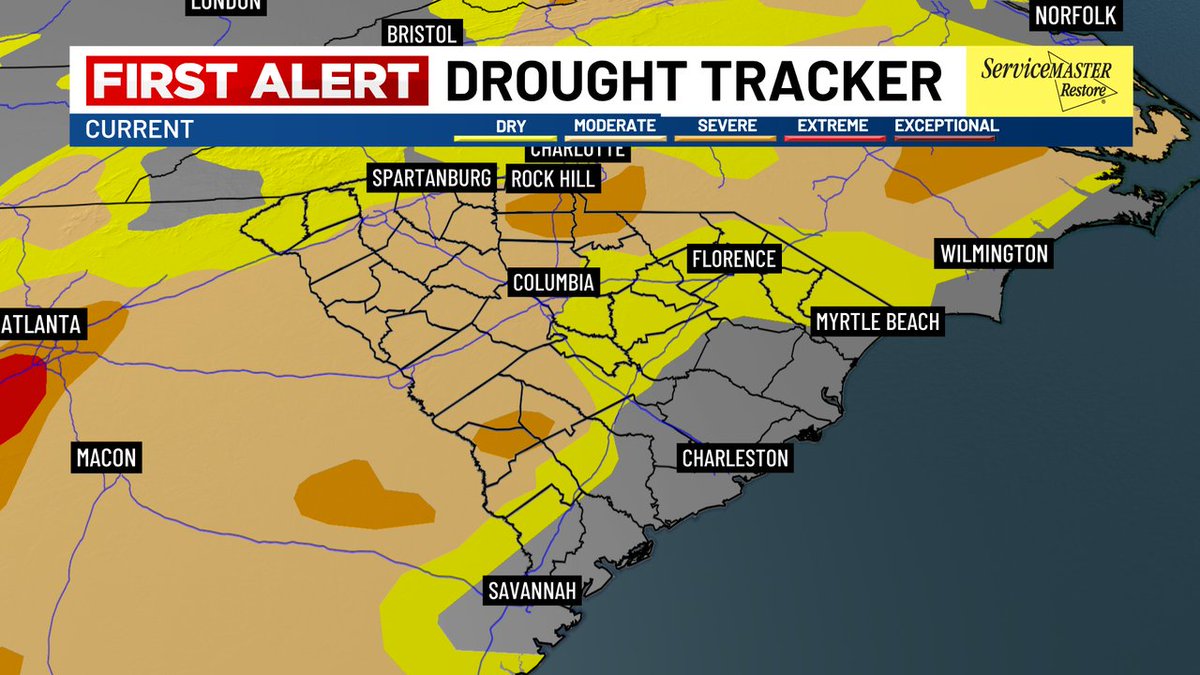
DROUGHT MONITOR: Although conditions have improved for most of the Lowcountry, some areas of moderate drought are ongoing west of I-95. This - combined with dry fuels - will allow for marginal fire weather conditions through Friday before humidity increases this weekend. #SCWX

DROUGHT MONITOR: Although conditions have improved for most of the Lowcountry, some areas of moderate drought are ongoing west of I-95. This - combined with dry fuels - will allow for marginal fire weather conditions through Friday before humidity increases this weekend. #SCWX
Meteorologist Dorien Minor (@minorwx) 's Twitter Profile Photo

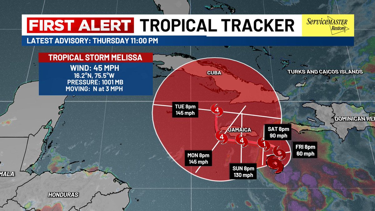
TROPICS: As of Thursday night, NOAA Hurricane Hunters found that the center of #Melissa has reformed further north! While this shift is minor, forecast trends now strongly point towards a strong, moisture-rich hurricane lingering in the Caribbean through early next week. #SCWX #Tropics

TROPICS: As of Thursday night, <a href="/NOAA/">NOAA</a> <a href="/53rdWRS/">Hurricane Hunters</a> found that the center of #Melissa has reformed further north! While this shift is minor, forecast trends now strongly point towards a strong, moisture-rich hurricane lingering in the Caribbean through early next week. #SCWX #Tropics
Joey Sovine Live 5 (@joeysovine) 's Twitter Profile Photo

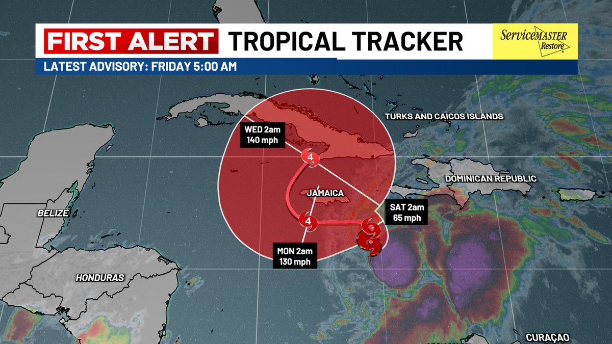
FIRST ALERT: Major concerns in the Caribbean! Tropical Storm Melissa is forecast to rapidly strengthen over the weekend. While the forecast has a lot of uncertainty, there are major concerns over the possible impacts from Jamaica to Cuba, Hispaniola and the Turks and Caicos.

FIRST ALERT: Major concerns in the Caribbean! 

Tropical Storm Melissa is forecast to rapidly strengthen over the weekend. While the forecast has a lot of uncertainty, there are major concerns over the possible impacts from Jamaica to Cuba, Hispaniola and the Turks and Caicos.
Bill Walsh (@billwalshtv) 's Twitter Profile Photo

FIRST ALERT// Tropical Update//Melissa is forecast to become a major hurricane over the next few days. She is in the Caribbean and threatens Jamaica, Cuba and Haiti along with the Bahamas. Models turn the storm north to northeast over time and no threat to the U.S. at this time.