Jess Langlois (@jesswcax) 's Twitter Profile
Jess Langlois

@jesswcax

First at 4:00 Meteorologist at @WCAX ✿ Nature Lover ✿ Musical Theatre Enthusiast ✿ @lyndonweather Alumna⚡

ID: 2581180517

linkhttps://www.wcax.com/weather/ calendar_today03-06-2014 19:32:43

3,3K Tweet

1,1K Followers

652 Following

Channel 3 First Alert Weather Team (@wcaxweather) 's Twitter Profile Photo

A Severe Thunderstorm Warning has been issued for the shaded area until Aug 05 7:00PM. If you are in the warning area, seek shelter in an enclosed building immediately.

Channel 3 First Alert Weather Team (@wcaxweather) 's Twitter Profile Photo

A Severe Thunderstorm Warning has been issued for the shaded area until Aug 07 6:15PM. If you are in the warning area, seek shelter in an enclosed building immediately.

Channel 3 First Alert Weather Team (@wcaxweather) 's Twitter Profile Photo

A Flash Flood Warning has been issued for the shaded area until 8/08 10:15PM. Plan for rapid water rises on rivers and streams and/or flooding of low-lying and poor drainage areas. Never drive through flood water.

Jess Langlois (@jesswcax) 's Twitter Profile Photo

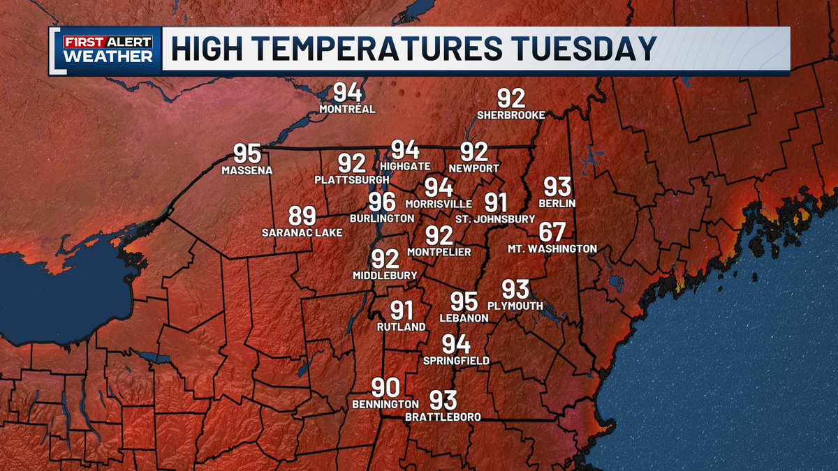
Hot out there today and hot again tomorrow! A Heat Advisory goes into effect for the Champlain Valley and St. Lawrence Valley at 8 AM Tuesday and remains in effect through Wednesday morning. Even the places that aren't technically included in the advisory will be hot.

Hot out there today and hot again tomorrow!
A Heat Advisory goes into effect for the Champlain Valley and St. Lawrence Valley at 8 AM Tuesday and remains in effect through Wednesday morning. Even the places that aren't technically included in the advisory will be hot.
Channel 3 First Alert Weather Team (@wcaxweather) 's Twitter Profile Photo

Wednesday is our best chance for needed rainfall this week but amounts will vary a lot by location due to the scattered nature of downpours and thunderstorms.

Channel 3 First Alert Weather Team (@wcaxweather) 's Twitter Profile Photo

A Severe Thunderstorm Warning has been issued for the shaded area until Aug 13 3:45PM. If you are in the warning area, seek shelter in an enclosed building immediately.

Channel 3 First Alert Weather Team (@wcaxweather) 's Twitter Profile Photo

Some of us are about to get some beneficial rainfall, but amounts will vary greatly by location. The hit or miss nature of these showers means amounts will range from a couple tenths of an inch or less to an inch or more through Monday.

Channel 3 First Alert Weather Team (@wcaxweather) 's Twitter Profile Photo

A Severe Thunderstorm Warning has been issued for the shaded area until Aug 24 6:00PM. If you are in the warning area, seek shelter in an enclosed building immediately.

Channel 3 First Alert Weather Team (@wcaxweather) 's Twitter Profile Photo

A Severe Thunderstorm Warning has been issued for the shaded area until Aug 24 6:30PM. If you are in the warning area, seek shelter in an enclosed building immediately.

Channel 3 First Alert Weather Team (@wcaxweather) 's Twitter Profile Photo

We'll stay cooler through Wednesday with variable cloud cover. You'll definitely need a sweater heading out the door. There will still be some hit or miss showers around, but they won't amount to much.

Channel 3 First Alert Weather Team (@wcaxweather) 's Twitter Profile Photo

Rain incoming! Plan for steady showers Friday morning, tapering to scattered showers in the afternoon. A stray thunderstorm or a few downpours are possible.

Channel 3 First Alert Weather Team (@wcaxweather) 's Twitter Profile Photo

A Severe Thunderstorm Warning has been issued for the shaded area until Sep 04 3:45PM. If you are in the warning area, seek shelter in an enclosed building immediately.

Channel 3 First Alert Weather Team (@wcaxweather) 's Twitter Profile Photo

A Severe Thunderstorm Warning has been issued for the shaded area until Sep 06 3:15PM. If you are in the warning area, seek shelter in an enclosed building immediately.

Channel 3 First Alert Weather Team (@wcaxweather) 's Twitter Profile Photo

A Severe Thunderstorm Warning has been issued for the shaded area until Sep 06 3:45PM. If you are in the warning area, seek shelter in an enclosed building immediately.

Jess Langlois (@jesswcax) 's Twitter Profile Photo

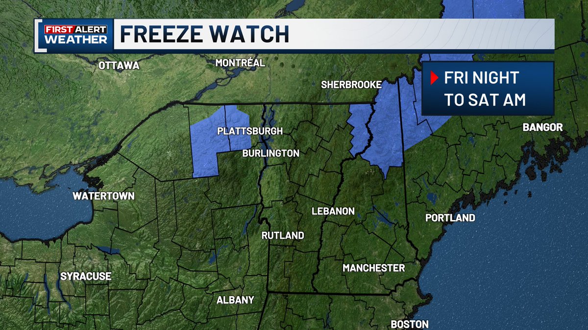
A Freeze Watch has been issued for parts of the Northeast Kingdom, Adirondacks, and northern New Hampshire Friday night into Saturday morning. Temperatures in the mid to upper 20s could kill crops, damage sensitive vegetation or unprotected outdoor plumbing.

A Freeze Watch has been issued for parts of the Northeast Kingdom, Adirondacks, and northern New Hampshire Friday night into Saturday morning. Temperatures in the mid to upper 20s could kill crops, damage sensitive vegetation or unprotected outdoor plumbing.
Channel 3 First Alert Weather Team (@wcaxweather) 's Twitter Profile Photo

No rain in the forecast again this week. Tomorrow's cold front comes through completely dry, but drops the temperatures through midweek. Widespread frost is likely by Thursday morning!