Jay Shafer, PhD (@jayshaferwx) 's Twitter Profile
Jay Shafer, PhD

@jayshaferwx

Sky watcher. Scientist. Dad. Entrepreneur. Educator. First responder to the future. Views my own.

ID: 412372671

calendar_today14-11-2011 16:12:20

1,1K Tweet

688 Takipçi

1,1K Takip Edilen

PowerOutage.us (@poweroutage_us) 's Twitter Profile Photo

Brian Potter wrote an in-depth essay for his newsletter "Construction Physics", analyzing customer outage minutes in different parts of the US, using our data. Link in comments.
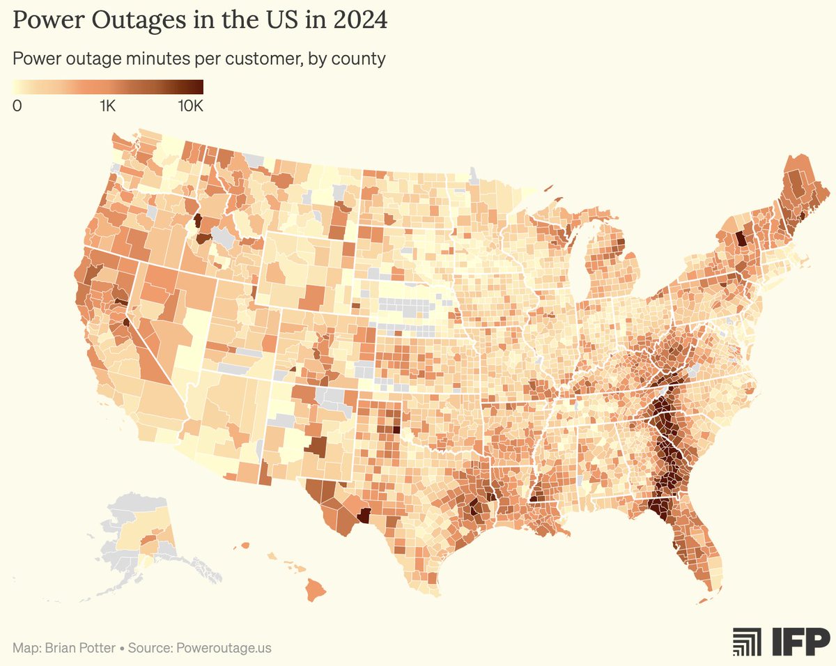
<a href="/_brianpotter/">Brian Potter</a> wrote an in-depth essay for his newsletter "Construction Physics", analyzing customer outage minutes in different parts of the US, using our data. Link in comments.
Jay Shafer, PhD (@jayshaferwx) 's Twitter Profile Photo

Landfalling hurricanes are relatively rare events - data from the last 8 seasons shows where hurricanes have made landfall, with LA and the west coast of FL having some of the most frequent and intense storms. PowerOutage.us
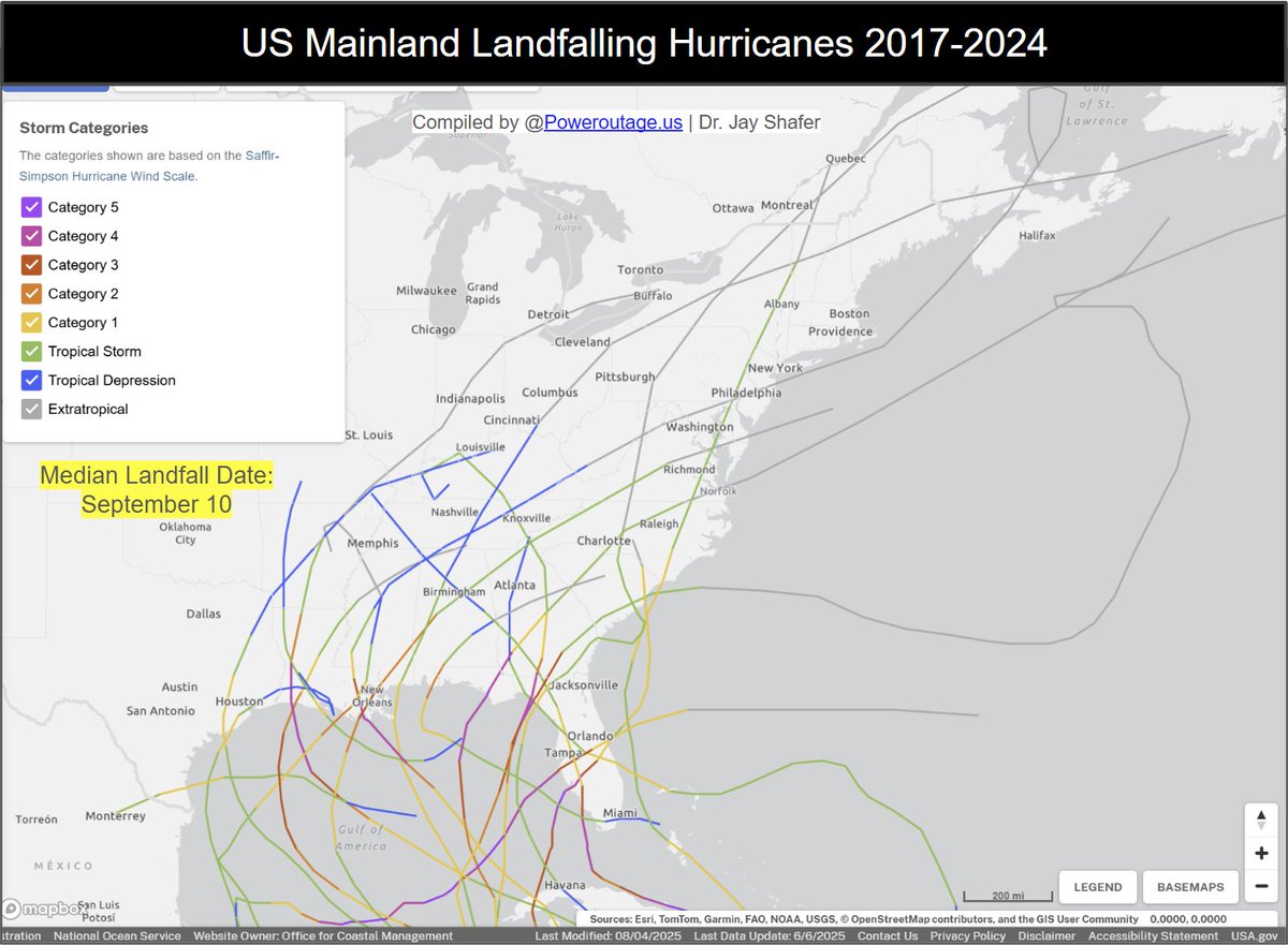
Landfalling hurricanes are relatively rare events - data from the last 8 seasons shows where hurricanes have made landfall, with LA and the west coast of FL having some of the most frequent and intense storms. <a href="/PowerOutage_us/">PowerOutage.us</a>
Jay Shafer, PhD (@jayshaferwx) 's Twitter Profile Photo

I'm proud of our re-launch with significant form and functional improvements as the source of truth for power outage information. poweroutage.us

Michael Ferragamo (@ferragamowx) 's Twitter Profile Photo

Putting the most-intense Atlantic hurricanes on a map, you can see just how extreme Hurricane #MELISSA is... #Jamaica's first Category 5 hurricane, and the first landfalling hurricane with a pressure below 900 mb in the Atlantic Basin in 95 years.

Putting the most-intense Atlantic hurricanes on a map, you can see just how extreme Hurricane #MELISSA is...

#Jamaica's first Category 5 hurricane, and the first landfalling hurricane with a pressure below 900 mb in the Atlantic Basin in 95 years.
PowerOutage.us (@poweroutage_us) 's Twitter Profile Photo

Power outages and radar reflectivity over the past 72 hours in 1 hour intervals. Nothing spookier than losing electricity. Happy Halloween. Stay safe. Hopefully everyone affected gets their power back on soon.

Jay Shafer, PhD (@jayshaferwx) 's Twitter Profile Photo

Do you make snow or not with the next cold wave - here's some analysis showing seasonal variability of snow making conditions snowshoemtn. Less than 10% of days during the second week of November have favorable snow making conditions. Winter nearly failed 2022-23 and 2023-24.
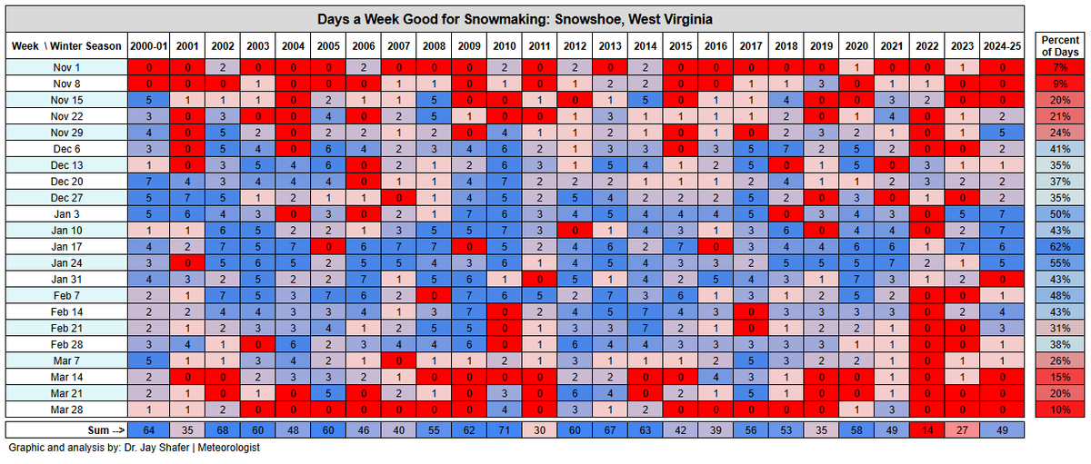
Do you make snow or not with the next cold wave - here's some analysis showing seasonal variability of snow making conditions <a href="/snowshoemtn/">snowshoemtn</a>. Less than 10% of days during the second week of November have favorable snow making conditions. Winter nearly failed 2022-23 and 2023-24.
Jay Shafer, PhD (@jayshaferwx) 's Twitter Profile Photo

We're in the second hour of widespread power outages in WY and SD. Powder River Energy Corp and Black Hills Energy are experiencing the greatest outages, with over 120,000 customers out as of 5:15 ET. Root cause appears related to energy supply shortage. Graphic PowerOutage.us
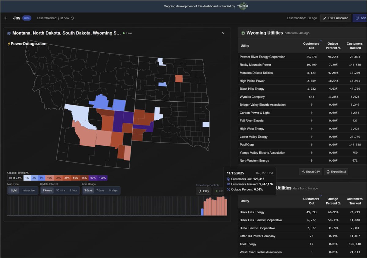
We're in the second hour of widespread power outages  in WY and SD. Powder River Energy Corp and Black Hills Energy are experiencing the greatest outages, with over 120,000 customers out as of 5:15 ET. Root cause appears related to energy supply shortage. Graphic <a href="/PowerOutage_us/">PowerOutage.us</a>
Jay Shafer, PhD (@jayshaferwx) 's Twitter Profile Photo

We continue to innovate PowerOutage.us , here's an evolution of power outages from the squall line that came through northern Alabama today. Up to 10% out in some counties and 2% statewide from Alabama Power . This product is exclusively available to electric utilities.

PowerOutage.us (@poweroutage_us) 's Twitter Profile Photo

Around 50,000 customers are without power this morning from wet snow accretion from OH to NJ. Cold temperatures and wind will slow restoration today. PECO Energy Co. AEP Ohio FirstEnergy Corp. are the most affected utilities.
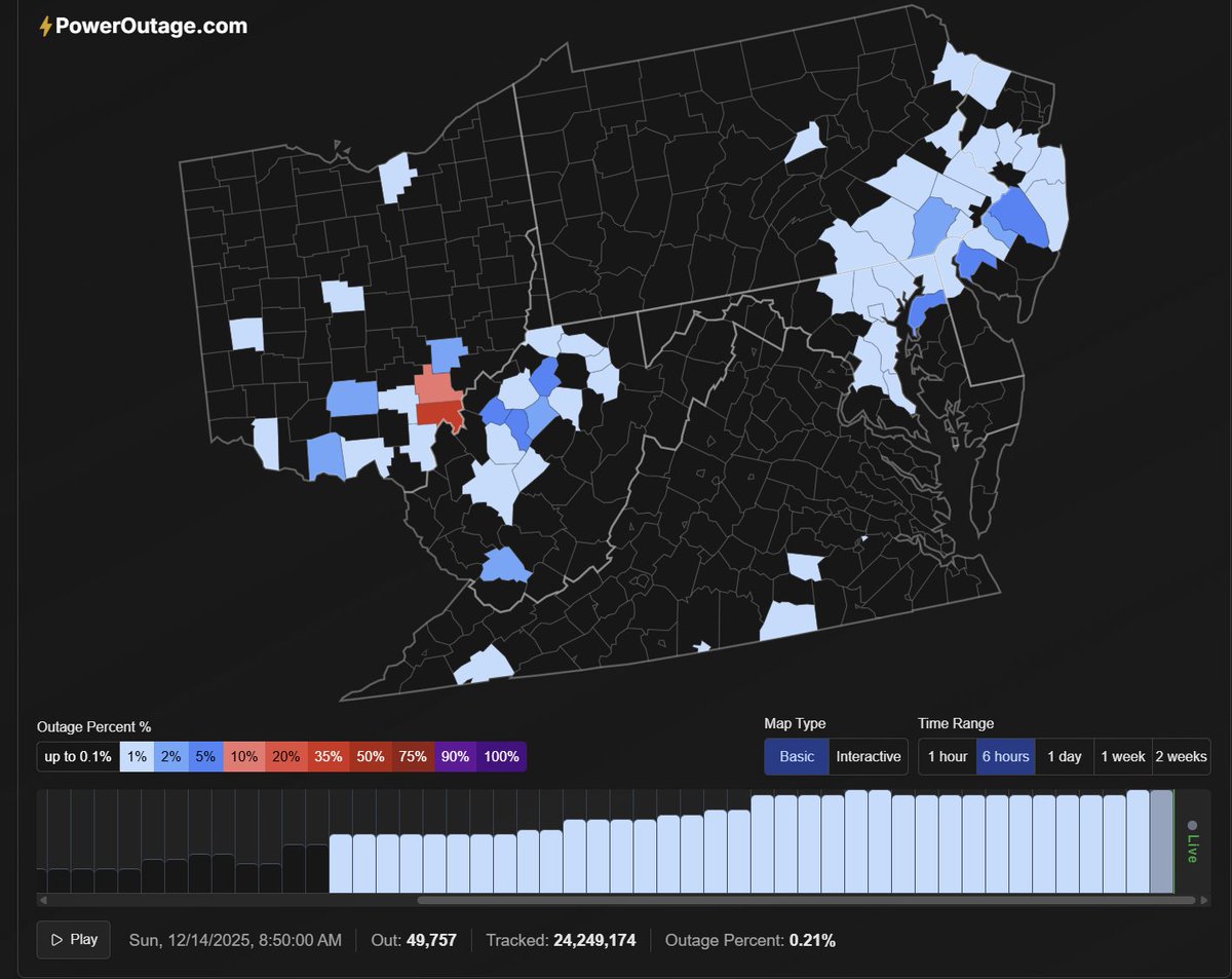
Around 50,000 customers are without power this morning from wet snow accretion from OH to NJ. Cold temperatures and wind will slow restoration today. <a href="/PECOEnergy/">PECO Energy Co.</a> <a href="/AEPOhio/">AEP Ohio</a> <a href="/firstenergycorp/">FirstEnergy Corp.</a> are the most affected utilities.
Jay Shafer, PhD (@jayshaferwx) 's Twitter Profile Photo

Widespread power outages from PowerOutage.us as the wind event moved through. Synchronous peak outages reached 624,000 customers - over 1 Million people at peak. WA experienced the greatest number of customers reaching 359,000. MT had the highest relative out at 14% (84,000).

PowerOutage.us (@poweroutage_us) 's Twitter Profile Photo

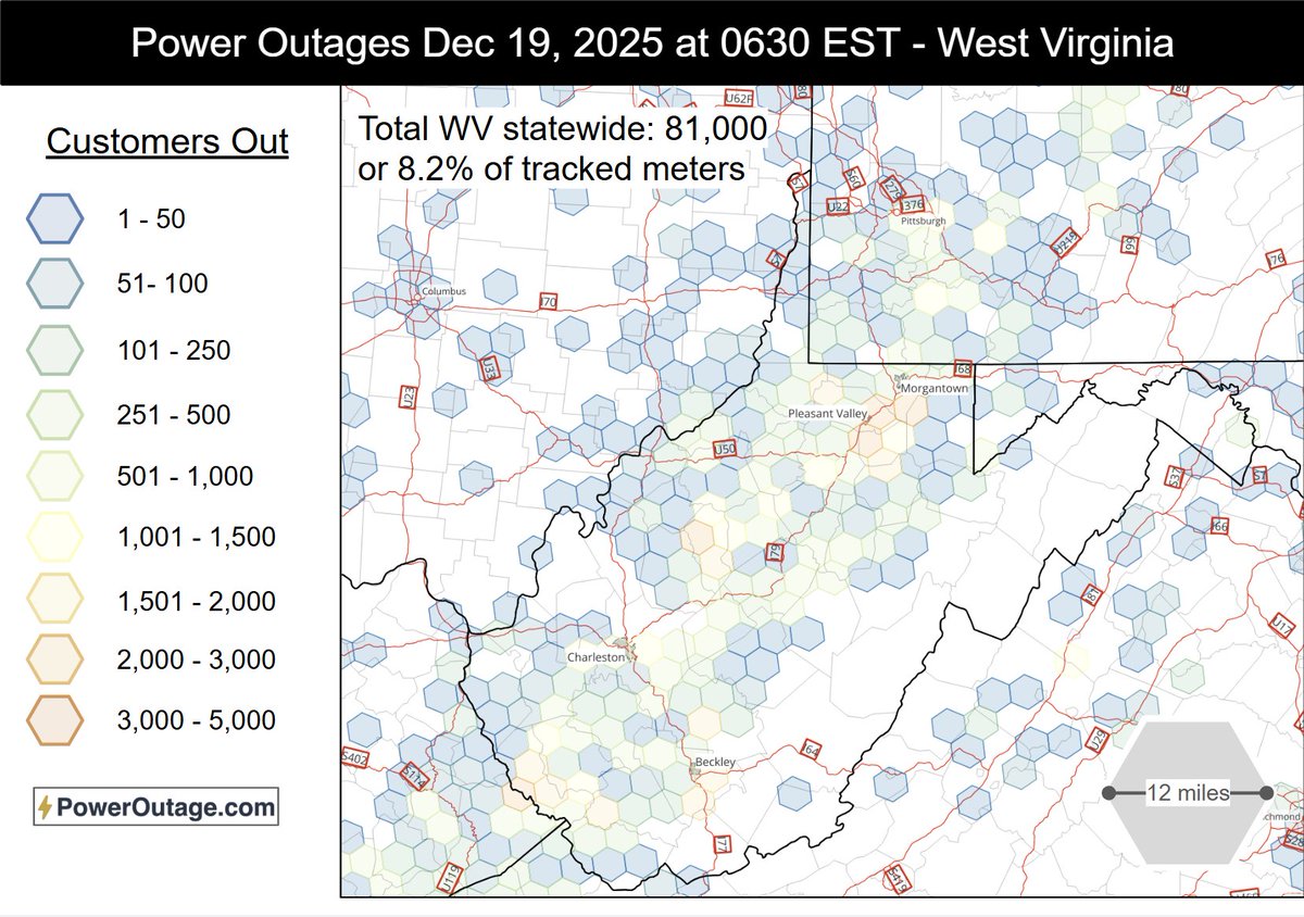
WV got hit the hardest in the east from the coast-to-coast storm system. As of 6:30 AM December 19, over 80,000 customers and 8% of the statewide population were without power due to high winds with the cold frontal passage. Widespread outages extend across much of WV with some

WV got hit the hardest in the east from the coast-to-coast storm system. As of 6:30 AM December 19, over 80,000 customers and 8% of the statewide population were without power due to high winds with the cold frontal passage. 

Widespread outages extend across much of WV with some
Jay Shafer, PhD (@jayshaferwx) 's Twitter Profile Photo

High-end freezing forecasts for PA are around 0.5" of liquid equivalent, which is just starting to get to the point of potentially causing power outages - limited grid impacts given shorter duration of fzra #pawx NOAA

High-end freezing forecasts for PA are around 0.5" of liquid equivalent, which is just starting to get to the point of potentially causing power outages - limited grid impacts given shorter duration of fzra #pawx <a href="/NOAA/">NOAA</a>
Jay Shafer, PhD (@jayshaferwx) 's Twitter Profile Photo

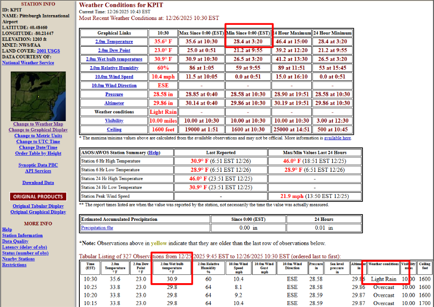
Subfreezing wet bulb temperature and subfreezing overnight temperatures = potential for roadway icing on untreated surfaces, especially on bridges

Subfreezing wet bulb temperature and subfreezing overnight temperatures = potential for roadway icing on untreated surfaces, especially on bridges
Jay Shafer, PhD (@jayshaferwx) 's Twitter Profile Photo

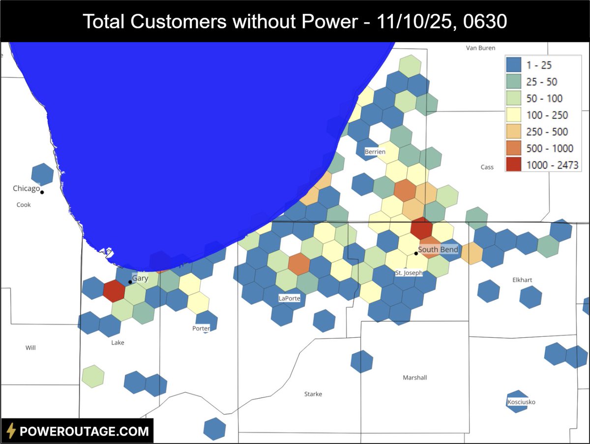
Great visual from PowerOutage.us showing the narrow zone of freezing rain accretion in Michigan where over 27K are without power currently. Looks like peak accretion Freezing rain is Mother Nature's f-word - the Grinch has arrived. At least no extreme cold coming immediately.
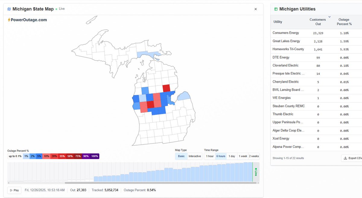
Great visual from <a href="/PowerOutage_us/">PowerOutage.us</a> showing the narrow zone of freezing rain accretion in Michigan where over 27K are without power currently. Looks like peak accretion Freezing rain is Mother Nature's f-word - the Grinch has arrived. At least no extreme cold coming immediately.
Jay Shafer, PhD (@jayshaferwx) 's Twitter Profile Photo

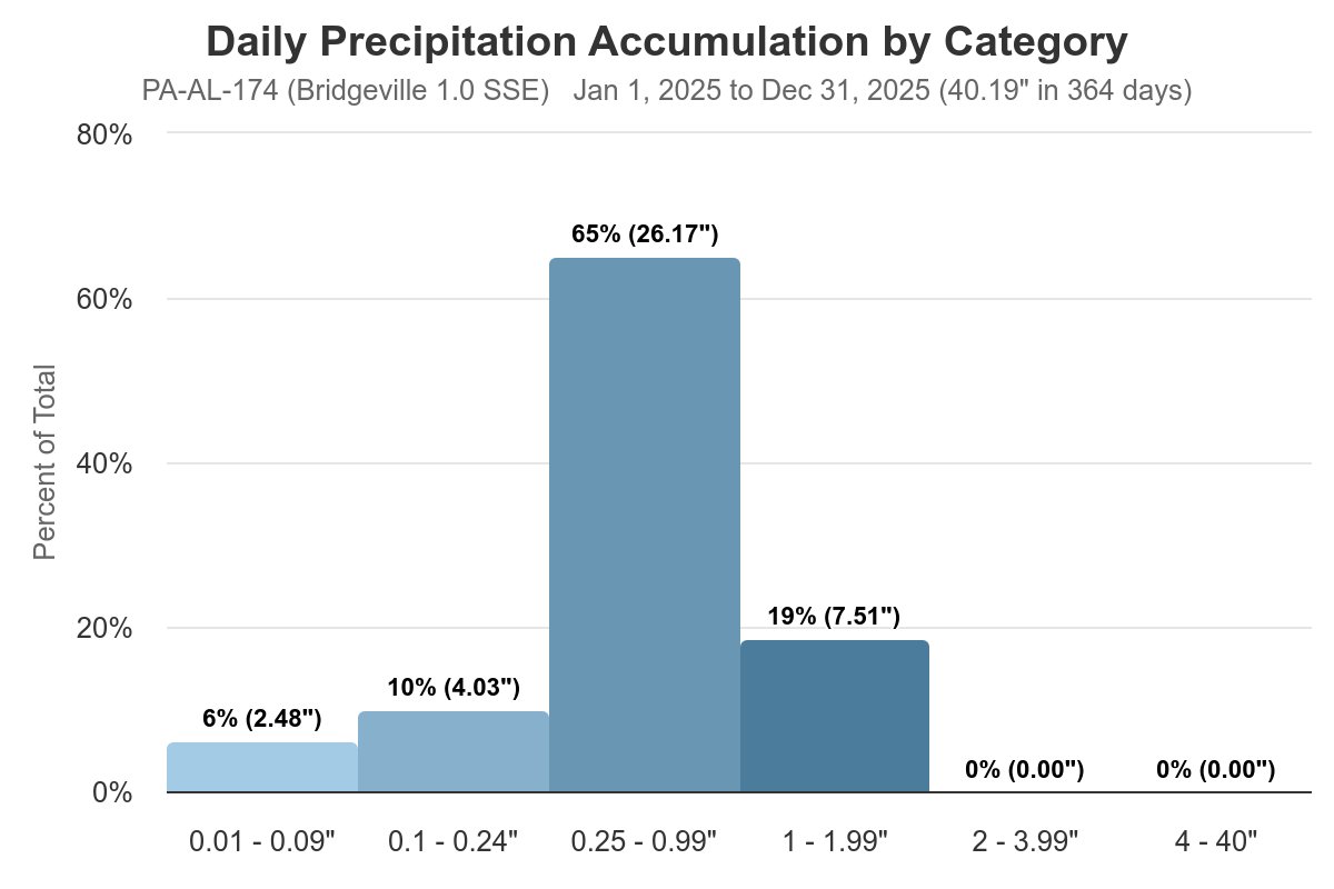
2025 precipitation ended right around average at my CoCoRaHS station. The only notable wet period was from late spring to early summer, otherwise relatively dry. Max 24-hr precipitation 1.89" May 22. Measurable precip 41% of days. #pawx #precipitation #Pittsburghweather

2025 precipitation ended right around average at my <a href="/CoCoRaHS/">CoCoRaHS</a> station. The only notable wet period was from late spring to early summer, otherwise relatively dry. Max 24-hr precipitation 1.89" May 22. Measurable precip 41% of days. #pawx #precipitation #Pittsburghweather