Jantien Stoter (@jantienstoter) 's Twitter Profile
Jantien Stoter

@jantienstoter

Professor 3D Geoinformation, TU Delft. Researcher at Kadaster and Geonovum. Interest: 3D geo-ICT solutions within use/policy contexts

ID: 280140430

linkhttps://3d.bk.tudelft.nl calendar_today10-04-2011 18:33:22

845 Tweet

958 Followers

287 Following

3D Geoinfo @TU Delft (@tudelft3d) 's Twitter Profile Photo

#30DayMapChallenge Day 4: Green Friday Trees from 6 Dutch cities reconstructed from point clouds using our software Adtree (github.com/tudelft3d/AdTr…). One was tilted by the strong Dutch wind. Can you guess which one?

#30DayMapChallenge Day 4: Green Friday

Trees from 6 Dutch cities reconstructed from point clouds using our software Adtree (github.com/tudelft3d/AdTr…). One was tilted by the strong Dutch wind. Can you guess which one?
3D Geoinfo @TU Delft (@tudelft3d) 's Twitter Profile Photo

#30DayMapChallenge Day 6: Network Cycle lanes in South Holland, the Netherlands. Did you know that you can just as easily cycle between cities as you can inside them? Generated using github.com/gboeing/osmnx, a python library for spatial data analysis from OpenStreetMap

#30DayMapChallenge Day 6: Network

Cycle lanes in South Holland, the Netherlands. Did you know that you can just as easily cycle between cities as you can inside them? Generated using github.com/gboeing/osmnx, a python library for spatial data analysis from OpenStreetMap
3D Geoinfo @TU Delft (@tudelft3d) 's Twitter Profile Photo

#30DayMapChallenge Day 7: Raster Summer sizzle in Amsterdam. Surface temperature on hot summer days (2018-2022), expressed as the difference from the mean (~28°C). Can you spot the hottest/coolest areas? 😎

#30DayMapChallenge Day 7: Raster

Summer sizzle in Amsterdam. Surface temperature on hot summer days (2018-2022), expressed as the difference from the mean (~28°C). Can you spot the hottest/coolest areas? 😎
3D Geoinfo @TU Delft (@tudelft3d) 's Twitter Profile Photo

#30DayMapChallenge Day 15: Food and drinks The most important map in our office is from the fridge to the eating table 😊 We used novel-view synthesis method nerfacto from nerfstudio to render the path to our fridge!

3D Geoinfo @TU Delft (@tudelft3d) 's Twitter Profile Photo

#30DayMapChallenge Day 16: Minimal The minimal elements for a good map! We did go a bit lazy on this one because we are preparing for the second half of the challenge 😇

#30DayMapChallenge Day 16: Minimal

The minimal elements for a good map! We did go a bit lazy on this one because we are preparing for the second half of the challenge 😇
3D Geoinfo @TU Delft (@tudelft3d) 's Twitter Profile Photo

#30DayMapChallenge Day 18: Blue Friday 3DBAG (3dbag.nl) from a #RoyalDelftBlue perspective. Looking forward to getting this ceramic tile from Royal Delft!
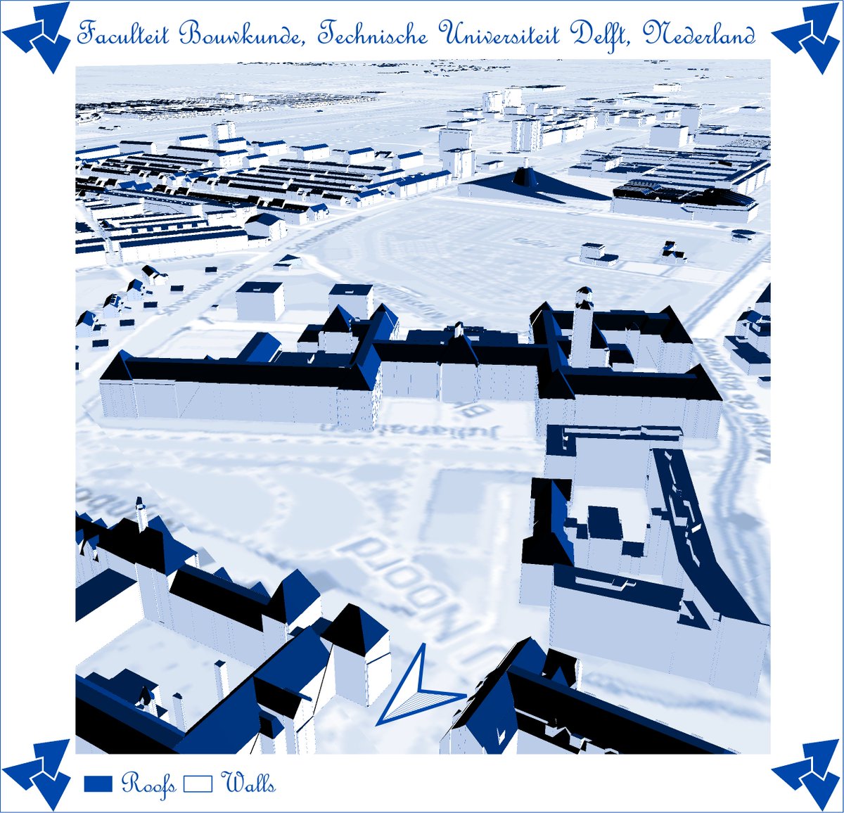
#30DayMapChallenge Day 18: Blue Friday

3DBAG (3dbag.nl) from a #RoyalDelftBlue perspective. Looking forward to getting this ceramic tile from <a href="/RoyalDelft/">Royal Delft</a>!
3D Geoinfo @TU Delft (@tudelft3d) 's Twitter Profile Photo

#30DayMapChallenge Day 28: 3D Why would you want 3D building models? This #blender render of our 3dbag.nl dataset showcases three possible answers to that question!

#30DayMapChallenge Day 28: 3D

Why would you want 3D building models? This #blender render of our 3dbag.nl dataset showcases three possible answers to that question!
3D Geoinfo @TU Delft (@tudelft3d) 's Twitter Profile Photo

#30DayMapChallenge Day 29: "Out of my comfort zone" This is a 4D polychoron, composed of two LoDs of a building, projected in 3D space and then rendered in 2D. Do you see it? 🤓 The map is created with azul4d: github.com/kenohori/azul4d

3D Geoinfo @TU Delft (@tudelft3d) 's Twitter Profile Photo

#30DayMapChallenge Day 30: Remix For the remix, we made a GIF of all of our maps. Sorry we think we’re just tired after this intensive month... and we need a break until the #30DayMapChallenge2023 !

IJGIS (@ijgis) 's Twitter Profile Photo

New paper: Inferring the number of floors for residential buildings by Roy E, Pronk M, Agugiaro G & Hugo Ledoux #ijgis tandfonline.com/doi/full/10.10…


CHEK digital building permit (@chekdbp) 's Twitter Profile Photo

Delft here we are. Awaiting our first in-person meetings that will take place from 16-17th of February 2023 at TU Delft. A lot of discussion, work and fun are in front of us.

3DBAG (@3d_bag) 's Twitter Profile Photo

De nieuwe 3D BAG release op basis van AHN4 data is eindelijk uit! Iedereen bedankt voor het geduld! Er is veel veranderd, lees de release notes op: docs.3dbag.nl/en/overview/re…

Francesca Noardo (@francescanoardo) 's Twitter Profile Photo

Workshop #Semantics: Role of semantic interoperability is about to start! Open Geospatial: OGC Alejandro Villar, Rob Atkinson Systems of systems #FAIR in action #HighValueDatasets and vocabularies for Essential Variables All Data 4 Green Deal USAGE project www4.gotomeeting.com/join/570236941

Workshop #Semantics: Role of semantic interoperability is about to start! <a href="/opengeospatial/">Open Geospatial: OGC</a>
Alejandro Villar, Rob Atkinson
Systems of systems
#FAIR in action
#HighValueDatasets and vocabularies for Essential Variables <a href="/ad4gd_project/">All Data 4 Green Deal</a> <a href="/USAGE_project/">USAGE project</a> 

www4.gotomeeting.com/join/570236941
Francesca Noardo (@francescanoardo) 's Twitter Profile Photo

Arne Schilling Virtual City Systems presented the CHEK digital building permit project approach to the modular and distributed software architecture for #DigitalBuildingPermit at the Data Week Leipzig and Open Geospatial: OGC EU Innovation days. slides: portal.ogc.org/files/?artifac… recording: portal.ogc.org/files/?artifac…

Arne Schilling <a href="/virtualcity/">Virtual City Systems</a> presented the <a href="/ChekDbp/">CHEK digital building permit</a>  project approach to the modular and distributed software architecture for #DigitalBuildingPermit at the <a href="/DataWeekLeipzig/">Data Week Leipzig</a> and <a href="/opengeospatial/">Open Geospatial: OGC</a> EU Innovation days.

slides: portal.ogc.org/files/?artifac…
recording: portal.ogc.org/files/?artifac…
3DBAG (@3d_bag) 's Twitter Profile Photo

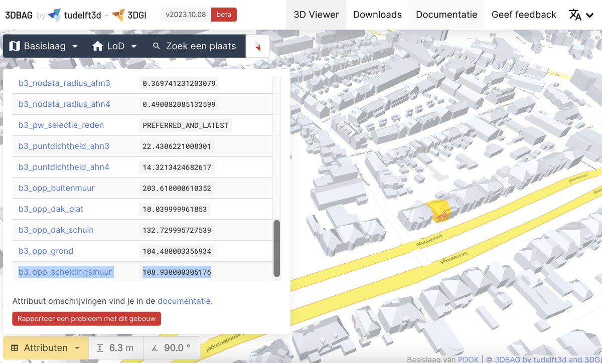
Versie 2023.10.08 van de 3DBAG is nu beschikbaar! Deze nieuwe versie bevat onder andere de oppervlaktes van pandscheidende muren en een nieuwe (experimentele) 3DBAG API waarmee je onze gebouwen direct in CityJSON en mét 3D geometrie kan opvragen. docs.3dbag.nl/nl/overview/re…

Versie 2023.10.08 van de 3DBAG is nu beschikbaar! Deze nieuwe versie bevat onder andere de oppervlaktes van pandscheidende muren en een nieuwe (experimentele) 3DBAG API waarmee je onze gebouwen direct in CityJSON en mét 3D geometrie kan opvragen.

docs.3dbag.nl/nl/overview/re…