Jacob L. Macdonald (@jacobmac02) 's Twitter Profile
Jacob L. Macdonald

@jacobmac02

NFLDer in the UK. Lecturer in GIS and Spatial Analysis - U. Sheffield @USPSheffield. Urban econ, big data, spatial stats & open science 🌎 (he/him)🇨🇦🇵🇹🇬🇧

ID: 33240389

linkhttp://www.jacobmacdonald.org calendar_today19-04-2009 16:28:35

414 Tweet

520 Takipçi

774 Takip Edilen

Jacob L. Macdonald (@jacobmac02) 's Twitter Profile Photo

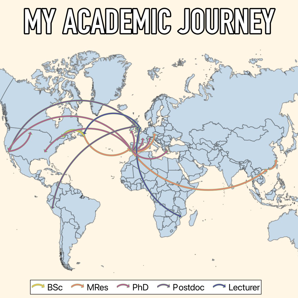
🗺️ DAY 5: JOURNEY - Going personal for todays #30DayMapChallenge on the theme of Journey. Here's a rough mapping out of my academic journey from bachelors to lecturer. 👶👨‍🎓👨‍🏫

🗺️  DAY 5: JOURNEY - Going personal for todays #30DayMapChallenge on the theme of Journey. Here's a rough mapping out of my academic journey from bachelors to lecturer. 👶👨‍🎓👨‍🏫
Jacob L. Macdonald (@jacobmac02) 's Twitter Profile Photo

🗺️ DAY 7: VINTAGE - Catch up time for the #30DayMapChallenge A pretty basic map playing with some QGIS coastal styles from Andy Woodruff to capture that vintage hand drawn effect.

🗺️  DAY 7: VINTAGE - Catch up time for the #30DayMapChallenge A pretty basic map playing with some QGIS coastal styles from <a href="/awoodruff/">Andy Woodruff</a> to capture that vintage hand drawn effect.
Jacob L. Macdonald (@jacobmac02) 's Twitter Profile Photo

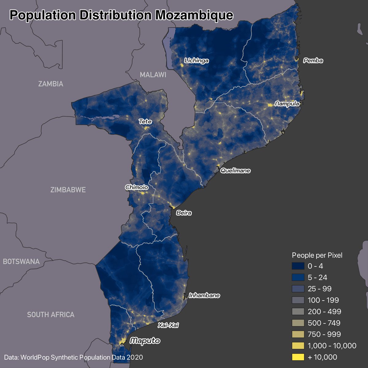
🗺️ DAY 8: HDX Data - Some great datasets on Humanitarian Data Exchange for the #30DayMapChallenge Here’s a map of population density in Mozambique using the WorldPop 2020 synthetic gridded data

🗺️  DAY 8: HDX Data - Some great datasets on Humanitarian Data Exchange for the #30DayMapChallenge Here’s a map of population density in Mozambique using the WorldPop 2020 synthetic gridded data
Jacob L. Macdonald (@jacobmac02) 's Twitter Profile Photo

🗺️ DAY 9/ 10: AI/ Pen and Paper - The UK as interpreted by ChatGPT, and Pangaea as interpreted by my hand for these two #30DayMapChallenge Been a while since I’ve gotten to do some arts and crafts! AI-UK just gets stranger the more you look

🗺️  DAY 9/ 10: AI/ Pen and Paper - The UK as interpreted by ChatGPT, and Pangaea as interpreted by my hand for these two #30DayMapChallenge Been a while since I’ve gotten to do some arts and crafts! AI-UK just gets stranger the more you look
Jacob L. Macdonald (@jacobmac02) 's Twitter Profile Photo

🗺️ DAY 11: ARCTIC - The Arctic Monkeys have never been to the Arctic for today's #30DayMapChallenge Of course working in Urban Studies and Planning at Sheffield University #Sheffield I had to go Sheffield-centric for the theme today. Some rough data work taken from concertarchives.org

🗺️  DAY 11: ARCTIC - The <a href="/ArcticMonkeys/">Arctic Monkeys</a> have never been to the Arctic for today's #30DayMapChallenge Of course working in <a href="/USPSheffield/">Urban Studies and Planning at Sheffield University</a> #Sheffield I had to go Sheffield-centric for the theme today. 

Some rough data work taken from concertarchives.org
Jacob L. Macdonald (@jacobmac02) 's Twitter Profile Photo

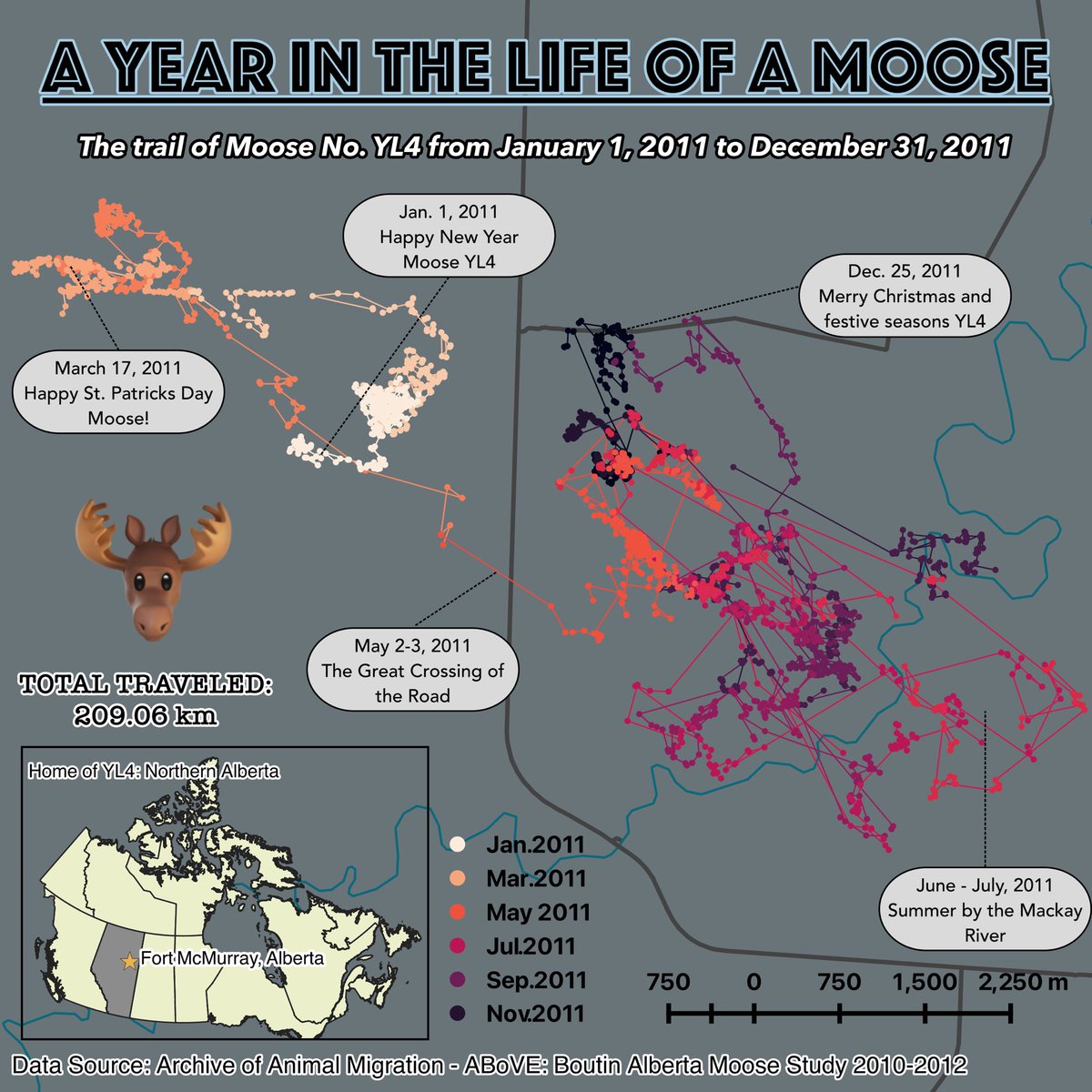
🗺️ DAY 12: SPACE & TIME - Spatio-temporal patterns for a random moose in Northern Alberta today for the #30DayMapChallenge 🫎 Here’s to Moose number YL4 🫡 movebank.org/cms/movebank-c…

🗺️  DAY 12: SPACE &amp; TIME - Spatio-temporal patterns for a random moose in Northern Alberta today for the #30DayMapChallenge 🫎 Here’s to Moose number YL4 🫡

movebank.org/cms/movebank-c…
Jacob L. Macdonald (@jacobmac02) 's Twitter Profile Photo

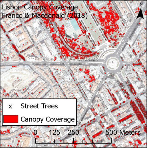
🗺️ DAY 13: NEW TOOL - Not exactly new, but relatively. ArcGIS Pro! I’m so used to QGIS and the former ArcMap, that Pro is still pretty new to me. Learning all along the way! #ESRI #ArcGIS #30DayMapChallenge Redoing some maps from my PhD tree canopy identification.

🗺️  DAY 13: NEW TOOL - Not exactly new, but relatively. ArcGIS Pro! I’m so used to QGIS and the former ArcMap, that Pro is still pretty new to me. Learning all along the way! #ESRI #ArcGIS #30DayMapChallenge

Redoing some maps from my PhD tree canopy identification.
Jacob L. Macdonald (@jacobmac02) 's Twitter Profile Photo

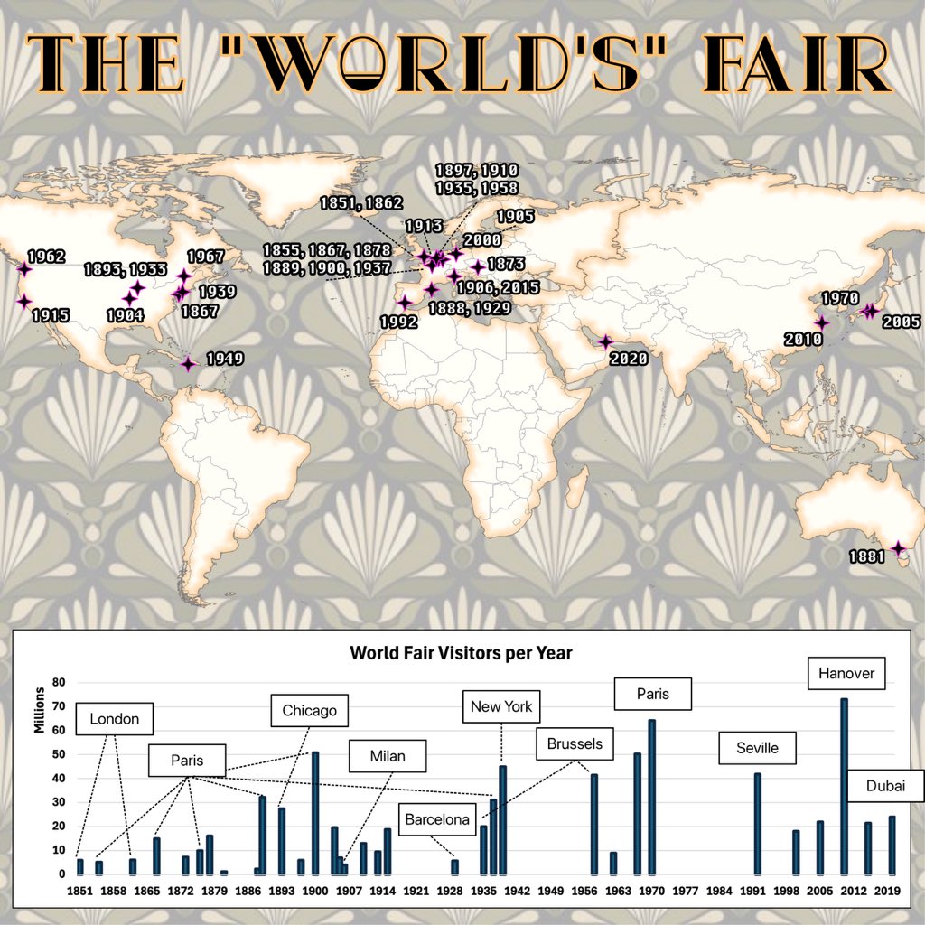
🗺️ DAY 14: WORLD - How Worldly is the distribution of the history of world fairs? Not much it seems according to today’s #30DayMapChallenge. If you’re into planning, architecture, the world fair and serial killers couldn’t recommend “Devil in the White City” enough!

🗺️  DAY 14: WORLD - How Worldly is the distribution of the history of world fairs? Not much it seems according to today’s #30DayMapChallenge. If you’re into planning, architecture, the world fair and serial killers couldn’t recommend “Devil in the White City” enough!
Jacob L. Macdonald (@jacobmac02) 's Twitter Profile Photo

🗺️ DAY 15: MY DATA - “Map something personal”… What’s the distribution of Jacob-based places around Great Britain? Using Ordnance Survey place names for today’s #30DayMapChallenge. Lots of Jacob’s ladders about.
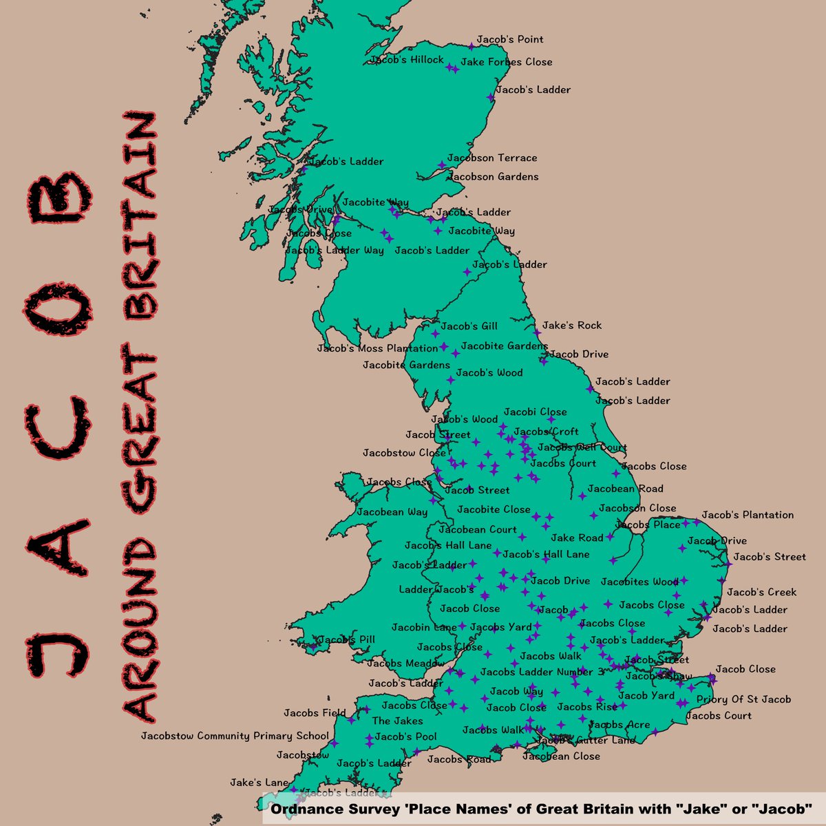
🗺️  DAY 15: MY DATA - “Map something personal”… What’s the distribution of Jacob-based places around Great Britain? Using <a href="/OrdnanceSurvey/">Ordnance Survey</a> place names for today’s #30DayMapChallenge. Lots of Jacob’s ladders about.
Jacob L. Macdonald (@jacobmac02) 's Twitter Profile Photo

It’s an alright map, but I don’t think I’d give many points for the use of GIS software. Looks like NL was just drawn in with a single colour green… map projections OK, but lots of empty space here we could make use of! #GIS #DatViz

Jacob L. Macdonald (@jacobmac02) 's Twitter Profile Photo

🗺️ DAY 16: CHOROPLETH - What does the UK look like when coloured in by #PremierLeague Premier League football club colours? That’s today’s #30DayMapChallenge! Obviously the polygon sizes aren’t proportionate to importance - LFC hidden away in their NW corner! ⚽️

🗺️  DAY 16: CHOROPLETH - What does the UK look like when coloured in by #PremierLeague <a href="/premierleague/">Premier League</a> football club colours? That’s today’s  #30DayMapChallenge! Obviously the polygon sizes aren’t proportionate to importance - LFC hidden away in their NW corner! ⚽️