UIUC Wind Engineering Research Lab (@windlaboratory) 's Twitter Profile
UIUC Wind Engineering Research Lab

@windlaboratory

Developing the techniques and physical resources necessary to extend current understanding of windstorm hazards and their impacts on structures.

ID: 845281836880330753

linkhttp://publish.illinois.edu/ftlombardo/ calendar_today24-03-2017 14:31:09

576 Tweet

671 Takipçi

418 Takip Edilen

Robby Frost (@robbyfrostwx) 's Twitter Profile Photo

🚨LONG THREAD WARNING🚨- Let's talk about tornadogenesis and the PBL: Markowski (2024) investigated tornadogenesis using a turbulent boundary layer in a supercell's environment and found near surface PBL structures to play an important role in the formation of a...

🚨LONG THREAD WARNING🚨- Let's talk about tornadogenesis and the PBL: Markowski (2024) investigated tornadogenesis using a turbulent boundary layer in a supercell's environment and found near surface PBL structures to play an important role in the formation of a...
NWS Chicago (@nwschicago) 's Twitter Profile Photo

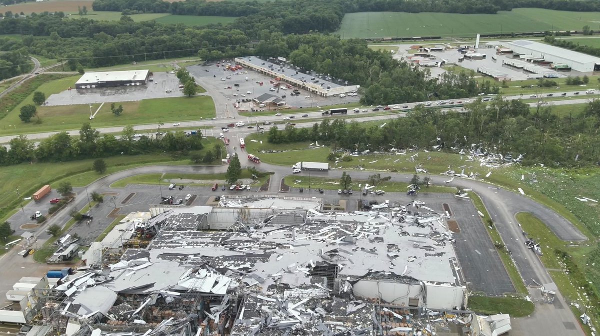
Sugar Grove to Batavia Tornado (Kane Co): EF-1 Elburn to Campton Hills Tornado (Kane Co): EF-0 Geneva Tornado (Kane Co): EF-1 Gary Tornado (Lake, IN Co): EF-1 South Barrington Tornado (Cook Co): EF-0 Inverness Tornado (Cook Co): EF-1

Kansas Mesonet (@ksmesonet) 's Twitter Profile Photo

Saturday night was ugly for our Cherokee station. A (possible) small tornado took out our tower and did localized damage. We didn't measure a big increase in winds but did measure a pressure change. We've placed a temp tripod to continue data collection. #kswx NWS Springfield
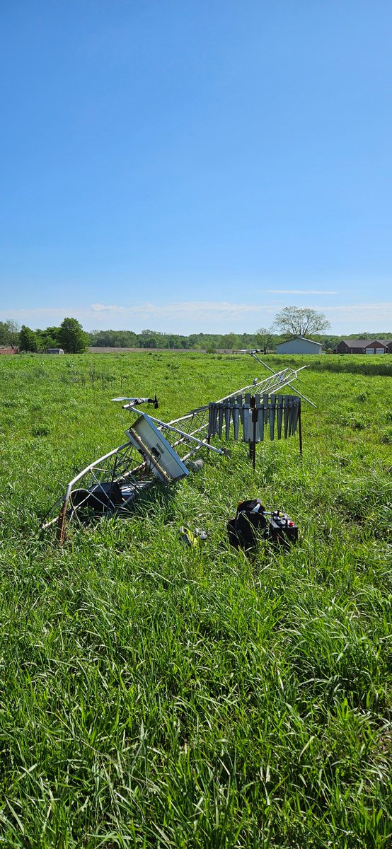
Saturday night was ugly for our Cherokee station. A (possible) small tornado took out our tower and did localized damage. We didn't measure a big increase in winds but did measure a pressure change. We've placed a temp tripod to continue data collection. #kswx <a href="/NWSSpringfield/">NWS Springfield</a>
NWS Chicago (@nwschicago) 's Twitter Profile Photo

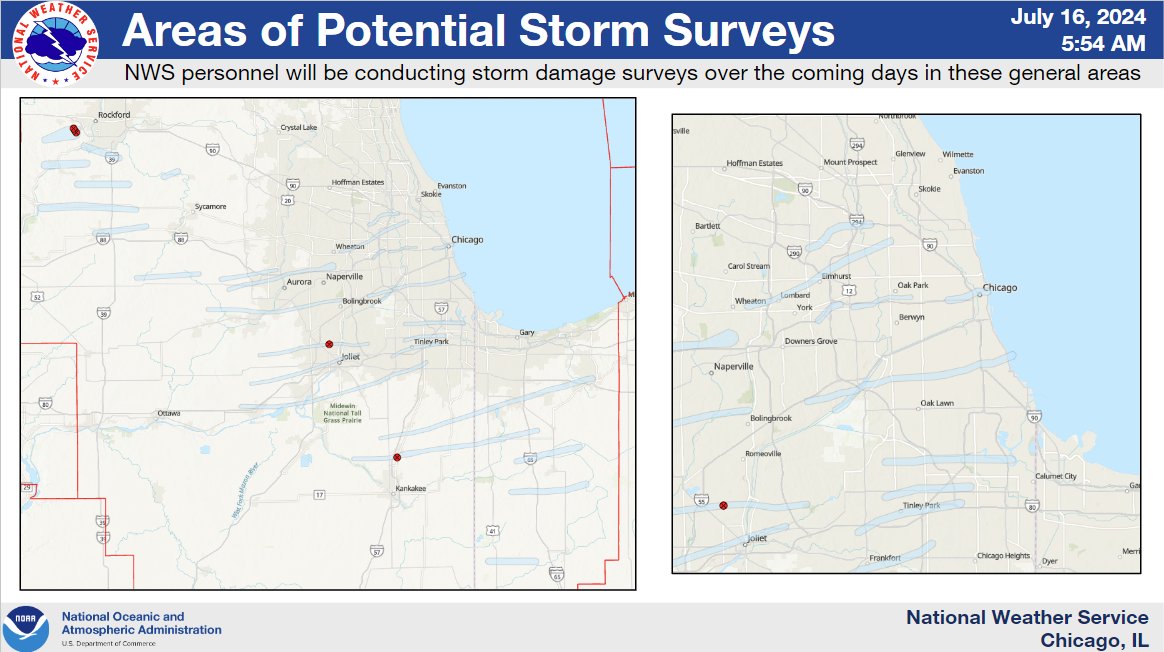
Good morning. Our office has 6 damage survey teams out surveying damage across northern Illinois and northwest Indiana today. So far, we have 29 different paths of potential damage that we will be investigating today and in the coming days to identify potential tornado tracks.

Good morning. Our office has 6 damage survey teams out surveying damage across northern Illinois and northwest Indiana today. So far, we have 29 different paths of potential damage that we will be investigating today and in the coming days to identify potential tornado tracks.
UIUC Wind Engineering Research Lab (@windlaboratory) 's Twitter Profile Photo

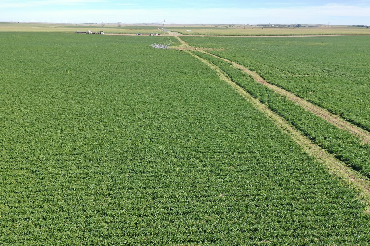
Labor Day Weekend was busy for the UIUC Wind Engineering Research Lab team. We surveyed the damage caused by the August 28th, 2024 Mound City, SD Tornado. Crop damage along with Transmission Line failures were documented. Stay tuned for more details! #tornado @NWSAbderdeen

Labor Day Weekend was busy for the UIUC Wind Engineering Research Lab team. We surveyed the damage caused by the August 28th, 2024 Mound City, SD Tornado. Crop damage along with Transmission Line failures were documented. Stay tuned for more details! #tornado @NWSAbderdeen
Matthew Graber (@wx_matthewg) 's Twitter Profile Photo

. David Roegner of UIUC Wind Engineering Research Lab discusses his work on machine learning as it relates to ASOS and radar data for wind load design. Here he is showing that the August 10, 2020 Iowa derecho was a 1 in 700-year event


. <a href="/dtroegner39/">David Roegner</a> of <a href="/WindLaboratory/">UIUC Wind Engineering Research Lab</a> discusses his work on machine learning as it relates to ASOS and radar data for wind load design. Here he is showing that the August 10, 2020 Iowa derecho was a 1 in 700-year event
NWS Los Angeles (@nwslosangeles) 's Twitter Profile Photo

Here are potential impacts for the upcoming strong winds Tuesday through Wednesday. Here's what you can do to prepare to help minimize impacts! #CAwx #SoCal #LA #LAwind #LosAngeles #VenturaCounty

Here are potential impacts for the upcoming strong winds Tuesday through Wednesday. Here's what you can do to prepare to help minimize impacts! #CAwx #SoCal #LA #LAwind #LosAngeles #VenturaCounty
Noah Bergren (@nbergwx) 's Twitter Profile Photo

in Lake Mary, Florida. About 4 mins from our TV station on Blue Iris Place. Two homes nearly leveled, about 6 with major damage. Path appears at least 1/2 a mile. FOX 35 Orlando

in Lake Mary, Florida. About 4 mins from our TV station on Blue Iris Place. Two homes nearly leveled, about 6 with major damage. Path appears at least 1/2 a mile. <a href="/fox35orlando/">FOX 35 Orlando</a>
Kevin Lighty - WCIA 3 Chief Meteorologist (@kevinlighty) 's Twitter Profile Photo

6 tornadoes confirmed from Friday night/Saturday morning. Neoga: EF-2, 120 mph, path 11.32 miles Mattoon: EF-1, 100 mph, path 0.57 miles Paris: EF-1, 90 mph, path 3.61 miles Lovington: EF1, 110 mph, path 5.06 miles Hammond: EF2, 115 mph, path 10.11 miles. Flatville-Gifford:

6 tornadoes confirmed from Friday night/Saturday morning. 

Neoga: EF-2, 120 mph, path 11.32 miles
Mattoon: EF-1, 100 mph, path 0.57 miles
Paris: EF-1, 90 mph, path 3.61 miles
Lovington:  EF1, 110 mph, path 5.06 miles
Hammond:  EF2, 115 mph, path 10.11 miles.
Flatville-Gifford:
Jonathan Erdman (@wxjerdman) 's Twitter Profile Photo

Today, the NWS will examine instruments at the Midland (TX) Int'l Air & Space Port to conclude if Tuesday's 111 mph gust set their all-time record during an apparent microburst. 📷 below: Stephen Allen & Priss Darrough via NWS Midland

Today, the NWS will examine instruments at the Midland (TX) Int'l Air &amp; Space Port to conclude if Tuesday's 111 mph gust set their all-time record during an apparent microburst. 

📷 below: Stephen Allen &amp; Priss Darrough via <a href="/NWSMidland/">NWS Midland</a>
Andrew Freedman (@afreedma) 's Twitter Profile Photo

NOAA's widely-used billion dollar disasters database is being retired, the agency revealed today, and will now span the years 1980-2024. Staff cuts, narrowing of focus (and scrutiny of climate-related datasets) are to blame. cnn.com/2025/05/08/cli…

𝐁𝐫𝐢𝐚𝐧 𝐒𝐜𝐡𝐧𝐞𝐞 (@brian_schnee) 's Twitter Profile Photo

🔥 FIRENADO 🌪️ #DeerCreekFire - San Juan County, Utah An EXTREMELY large fire whirl was observed by firefighters on Saturday, July 12 in the early afternoon being called a “vortex/tornado ordeal” by fire managers. Debris can be seen flying through the air as the ‘firenado’

MNStorm (@mn_storm) 's Twitter Profile Photo

inciweb.wildfire.gov/incident-video… More incredible footage of the tornadic vortex that occurred a few days ago on the #DeerCreekFire. #cowx

Neil Lareau (@nplareau) 's Twitter Profile Photo

As my research group continues to probe the factors contributing to the #DeerCreekFire's EF-2 fire-generated vortex (FGV), one possible vorticity source appears to be coherent terrain-forced cyclonic flow in the lee of the La Sal mountains. Here are the HRRR near surface wind