Jamie Driver (@jamiedriver7) 's Twitter Profile
Jamie Driver

@jamiedriver7

25 |🇬🇧| Aviation Meteorologist @metoffice | MMet Meteorology and Climate @UniRdg_Met + @ousom | All opinions here are my own and don’t represent my employer

ID: 884007990629728256

calendar_today09-07-2017 11:15:03

1,1K Tweet

233 Takipçi

430 Takip Edilen
NWS Norman (@nwsnorman) 's Twitter Profile Photo

I know it is April Fool's Day but this is no joke. Severe storms will be likely late this afternoon and evening with very large hail, damaging winds, and tornadoes possible. Stay weather aware today, have a plan, and be safe! #okwx #texomawx

I know it is April Fool's Day but this is no joke. Severe storms will be likely late this afternoon and evening with very large hail, damaging winds, and tornadoes possible. Stay weather aware today, have a plan, and be safe! #okwx #texomawx
NWS Storm Prediction Center (@nwsspc) 's Twitter Profile Photo

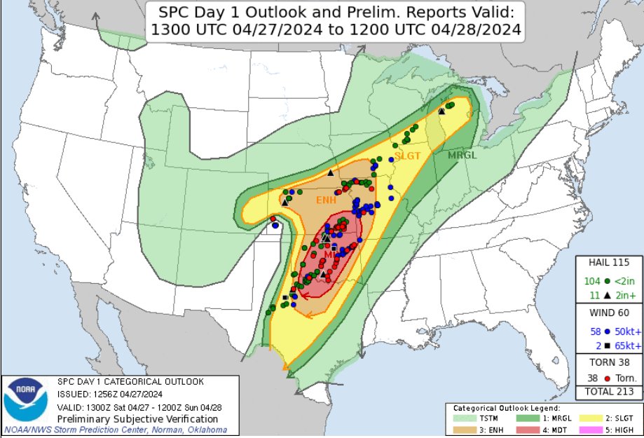
1:06am CDT #SPC Day1 Outlook Moderate Risk: across parts of North Texas Oklahoma Southeast Kansas and Far Southwest Missouri spc.noaa.gov/products/outlo…

1:06am CDT #SPC Day1 Outlook Moderate Risk: across parts of North Texas Oklahoma Southeast Kansas and Far Southwest Missouri spc.noaa.gov/products/outlo…
Ben Sainsbury (@ben_weather) 's Twitter Profile Photo

The day has finally come where myself & Bristolstormchaser are heading out to the US for our two week storm chasing trip, then meeting Jamie Driver half way through! Looks like an active stretch of severe weather coming up with a big day possible tomorrow, so lots to look forward to🌪️⚡️

NWS Storm Prediction Center (@nwsspc) 's Twitter Profile Photo

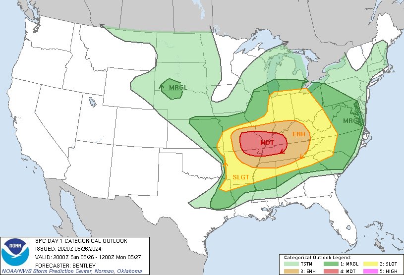
11:42am CDT #SPC Day1 Outlook Enhanced Risk: from the Ozarks into portions of the Ohio/Tennessee Valley Region spc.noaa.gov/products/outlo…

11:42am CDT #SPC Day1 Outlook Enhanced Risk: from the Ozarks into portions of the Ohio/Tennessee Valley Region spc.noaa.gov/products/outlo…
NWS Storm Prediction Center (@nwsspc) 's Twitter Profile Photo

3:22pm CDT #SPC Day1 Outlook Moderate Risk: across south-central and southeast Missouri, far northeast Arkansas, southern Illinois, far southwest Indiana, western Kentucky, and northwest Tennessee. spc.noaa.gov/products/outlo…

3:22pm CDT #SPC Day1 Outlook Moderate Risk: across south-central and southeast Missouri, far northeast Arkansas, southern Illinois, far southwest Indiana, western Kentucky, and northwest Tennessee. spc.noaa.gov/products/outlo…
Philip Klotzbach (@philklotzbach) 's Twitter Profile Photo

#Milton is now a Category 5 #hurricane with max winds of 160 mph. Milton joins Michael as the only October Category 5 hurricanes in the Gulf of Mexico in the satellite era (1966-onwards).

NWS Storm Prediction Center (@nwsspc) 's Twitter Profile Photo

7:55am CDT #SPC Day1 Outlook Moderate Risk: for southwest and central Kansas into far northwest Oklahoma spc.noaa.gov/products/outlo…

7:55am CDT #SPC Day1 Outlook Moderate Risk: for southwest and central Kansas into far northwest Oklahoma spc.noaa.gov/products/outlo…
CIRA (@cira_csu) 's Twitter Profile Photo

Compelling satellite imagery of an outflow racing away from thunderstorms, becoming the catalyst for a new round of severe storms in Texas this afternoon.