Heba Shalaby (@hebashalaby) 's Twitter Profile
Heba Shalaby

@hebashalaby

Computing enthusiast.

ID: 1040441132566700032

calendar_today14-09-2018 03:24:31

19 Tweet

23 Takipçi

51 Takip Edilen

Sean Elvidge (@seanelvidge) 's Twitter Profile Photo

Dr PlasmaNerd 🌏 🛰️ Julie Brett Carter Radio Occultation (RO) is the process of a (radio) signal changing as it passes through the atmosphere. It is used a lot in the met community, but in our case we care about the refraction of the signal caused by the ionosphere (the signal is 'occulted').
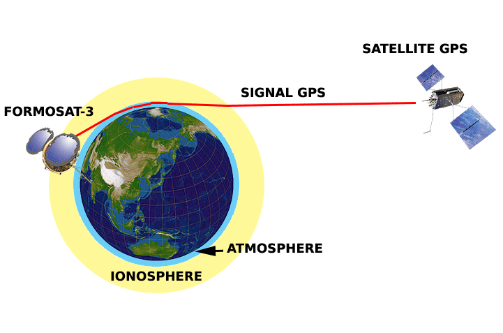
<a href="/PlasmaNerd/">Dr PlasmaNerd 🌏 🛰️</a> <a href="/j11lc/">Julie</a> <a href="/DrBrettCarter/">Brett Carter</a> Radio Occultation (RO) is the process of a (radio) signal changing as it passes through the atmosphere. It is used a lot in the met community, but in our case we care about the refraction of the signal caused by the ionosphere (the signal is 'occulted').
Sean Elvidge (@seanelvidge) 's Twitter Profile Photo

Dr PlasmaNerd 🌏 🛰️ Julie Brett Carter It gives us measurements of the 'total electron content' (TEC) in the ionosphere, which is the most abundant data we have of the ionosphere. We need for our data assimilation models. Attached shows the TEC from a 15 minute period using ground based receivers.
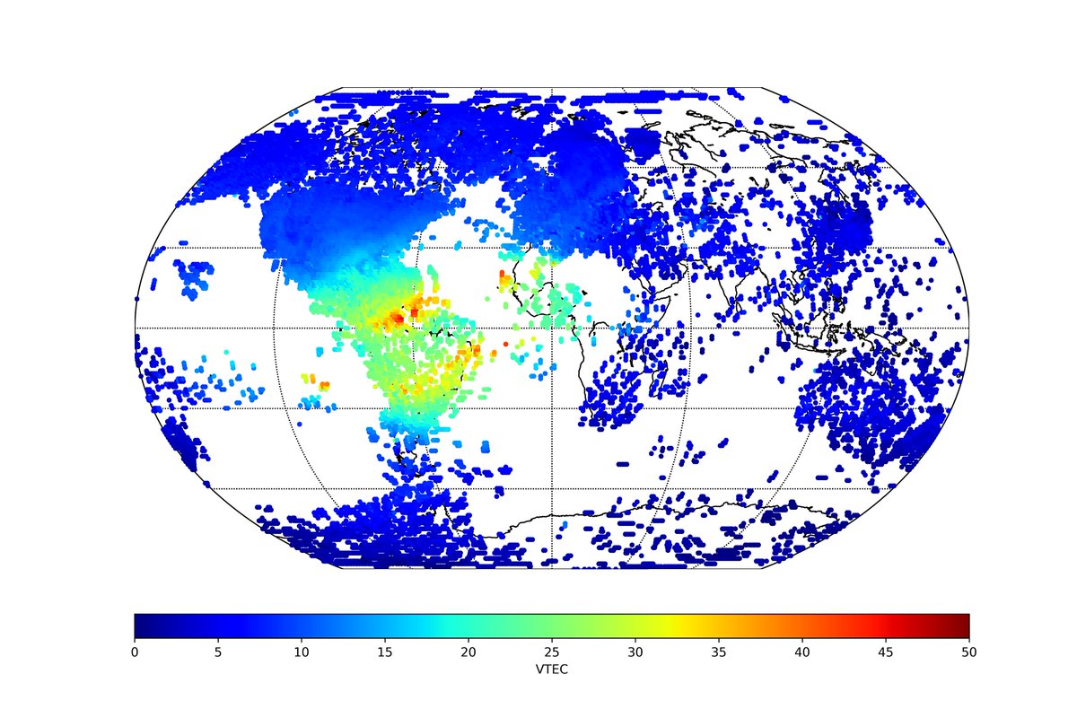
<a href="/PlasmaNerd/">Dr PlasmaNerd 🌏 🛰️</a> <a href="/j11lc/">Julie</a> <a href="/DrBrettCarter/">Brett Carter</a> It gives us measurements of the 'total electron content' (TEC) in the ionosphere, which is the most abundant data we have of the ionosphere. We need for our data assimilation models. Attached shows the TEC from a 15 minute period using ground based receivers.
Google AI (@googleai) 's Twitter Profile Photo

Reconstructing scene depth from video with moving subjects can be very challenging. Now there’s a #DeepLearning approach that generates accurate 3D depth maps from ordinary video, even when both camera and subjects are in motion. Learn more at → goo.gle/2HxYqCm

NASA Sun & Space (@nasasun) 's Twitter Profile Photo

Signals between satellites and the ground — like GPS — can be disrupted by hard-to-predict bubbles in Earth's upper atmosphere. These twin satellites will help us study when and how these bubbles can appear and scramble signals. Meet E-TBEx: go.nasa.gov/2WpVkEV

Signals between satellites and the ground — like GPS — can be disrupted by hard-to-predict bubbles in Earth's upper atmosphere. These twin satellites will help us study when and how these bubbles can appear and scramble signals. Meet E-TBEx: go.nasa.gov/2WpVkEV
Fermat's Library (@fermatslibrary) 's Twitter Profile Photo

Why are some things darker when wet? It's an interesting question and you just need some basic knowledge about elementary optics to understand it. Learn more here: fermatslibrary.com/s/why-some-thi… A great paper for your summer ☀️reading list 📚

Why are some things darker when wet?

It's an interesting question and you just need some basic knowledge about elementary optics to understand it. Learn more here: fermatslibrary.com/s/why-some-thi…

A great paper for your summer ☀️reading list 📚
Mike Flynn (@mikeflynn55) 's Twitter Profile Photo

“Good mathematics is not about how many answers you know…It’s how you behave when you don’t know.” ~Author unknown. #MtHolyokeMath

“Good mathematics is not about how many answers you know…It’s how you behave when you don’t know.” ~Author unknown. #MtHolyokeMath
Laura A. Hayes (@laura_hayess) 's Twitter Profile Photo

Monica highlights the need to adopt a modern scientific workflow (e.g. open source (The SunPy Project ;)) reproducibility etc) as the next steps forward in using #ML for solar flare predictions #mlhelio19 ML-Helio

Monica highlights the need to adopt a modern scientific workflow (e.g. open source (<a href="/SunPyProject/">The SunPy Project</a> ;)) reproducibility etc) as the next steps forward in using #ML for solar flare predictions #mlhelio19 <a href="/MlHelio/">ML-Helio</a>
Dr Marco Langbroek (@marco_langbroek) 's Twitter Profile Photo

We all have used satellite navigation: but have you ever seen the satellites in the sky? On Nov 6, I imaged representative Navigation satellites from four constellations: NAVSTAR 73 (GPS); GALILEO 21; BEIDOU 3M7; and KOSMOS 2501 (GLONASS).

We all have used satellite navigation: but have you ever seen the satellites in the sky?
On Nov 6, I imaged representative Navigation satellites from four constellations: 
NAVSTAR 73 (GPS); GALILEO 21; BEIDOU 3M7; and KOSMOS 2501 (GLONASS).