Camilo Ruiz USAL (@copilco1) 's Twitter Profile
Camilo Ruiz USAL

@copilco1

Optics & Education

ID: 8932752

linkhttp://www.usal.es calendar_today17-09-2007 15:46:26

27,27K Tweet

1,1K Takipçi

4,4K Takip Edilen

Nahel Belgherze (@wxnb_) 's Twitter Profile Photo

Before-and-after satellite imagery shows multiple large burn scars from the recent major wildfires in Portugal and Spain. Just terrible.

educación forestal (@eforestal) 's Twitter Profile Photo

🔥Las provincias más afectadas por los 5⃣4⃣ Grandes Incendios Forestales 2025 a fecha de 25/08/2025 son Ourense y León, con unas 104000 hectáreas cada una. 🔗edu.forestry.es/p/gif2025.html

🔥Las provincias más afectadas por los 
5⃣4⃣ Grandes Incendios Forestales 2025 a fecha de 25/08/2025 son Ourense y León, con unas 104000 hectáreas cada una.

🔗edu.forestry.es/p/gif2025.html
Google Earth (@googleearth) 's Twitter Profile Photo

🌏📊 Earth Engine in BigQuery is now generally available, bringing advanced geospatial analytics and map visualization directly to your BigQuery workflows. Unlock insights with satellite data → bit.ly/3Hw5wcF #EarthEngine #BigQuery #Geospatial

🌏📊 Earth Engine in BigQuery is now generally available, bringing advanced geospatial analytics and map visualization directly to your BigQuery workflows. Unlock insights with satellite data → bit.ly/3Hw5wcF
#EarthEngine #BigQuery #Geospatial
CIRA (@cira_csu) 's Twitter Profile Photo

The remnants of Hurricane Erin, now a post-tropical cyclone, approaches the British Isles in this striking satellite imagery taken earlier today by NOAA-21.

The remnants of Hurricane Erin, now a post-tropical cyclone, approaches the British Isles in this striking satellite imagery taken earlier today by NOAA-21.
Nahel Belgherze (@wxnb_) 's Twitter Profile Photo

Here’s a 48-hour water vapor satellite loop of Ex-Hurricane Erin making its final approach to western Europe. Truly mesmerizing.

NOAA (@noaa) 's Twitter Profile Photo

20 years ago, Hurricane Katrina tore through the southeastern United States, causing much destruction. In this video, featuring thoughts from NOAA staff, we remember Katrina, and the further forecasting advancements since then. noaa.gov/heritage/multi…

educación forestal (@eforestal) 's Twitter Profile Photo

🔥🇪🇸2025 está pasando a la historia como el año con peor registro en superficie media por cada Gran Incendio Forestal. Rondando las 6100 ha/GIF cuando la media está en 1500 ha/GIF Cada vez son menos, pero más poderosos.

🔥🇪🇸2025 está pasando a la historia como el año con peor registro en superficie media por cada Gran Incendio Forestal. Rondando las 6100 ha/GIF cuando la media está en 1500 ha/GIF

Cada vez son menos, pero más poderosos.
educación forestal (@eforestal) 's Twitter Profile Photo

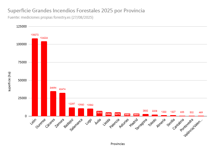
🔥Superficie quemada en cada provincia por los Grandes Incendios Forestales hasta hoy. (mediciones propias) edu.forestry.es/p/gif2025.html

🔥Superficie quemada en cada provincia por los Grandes Incendios Forestales hasta hoy. 

(mediciones propias)

edu.forestry.es/p/gif2025.html
Peter Dynes (@pgdynes) 's Twitter Profile Photo

European wildfires are no accident. Fueled by climate change and profit-driven neglect, they’ve reached a staggering scale: by August 26, over 1 million hectares had burned across the EU in 2025—four times the 20-year average. The climate crisis and pyrocene are already here.

European wildfires are no accident. Fueled by climate change and profit-driven neglect, they’ve reached a staggering scale: by August 26, over 1 million hectares had burned across the EU in 2025—four times the 20-year average. The climate crisis and pyrocene are already here.
NHC_TAFB (@nhc_tafb) 's Twitter Profile Photo

Cape Verde-type hurricanes are those Atlantic basin tropical cyclones that develop into tropical storms fairly close (<1000 km [600 mi] or so) of the Cape Verde Islands and then become hurricanes before reaching the Caribbean. Typically, this may occur in August and September.

Cape Verde-type hurricanes are those Atlantic basin tropical cyclones that develop into tropical storms fairly close (&lt;1000 km [600 mi] or so) of the Cape Verde Islands and then become hurricanes before reaching the Caribbean. Typically, this may occur in August and September.
Thomas Reis (@peakaustria) 's Twitter Profile Photo

The summer in comparison since 1767: Shown are the above-average warm (red) and cold (blue) summers since 1767 compared to the climate reference period 1961–1990, based on GeoSphere Austria HISTALP lowland data. The smoothed trend line is drawn in black. © GeoSphere Austria.

The summer in comparison since 1767: Shown are the above-average warm (red) and cold (blue) summers since 1767 compared to the climate reference period 1961–1990, based on GeoSphere Austria HISTALP lowland data. The smoothed trend line is drawn in black. © GeoSphere Austria.
Copernicus ECMWF (@copernicusecmwf) 's Twitter Profile Photo

📈  Thermal Trace map shows feels-like temps reaching 46°C in Spain on 15 August - Rebecca Emerton, #C3S  📈 July '25 temperature anomalies in the Arctic circle - ACCAP  📈 Highest temperature of 2025 (May 1 through Aug 15) in North America - Brian Brettschneider

📈  Thermal Trace map shows feels-like temps reaching 46°C in Spain on 15 August - Rebecca Emerton, #C3S 
📈 July '25 temperature anomalies in the Arctic circle - ACCAP 
📈 Highest temperature of 2025 (May 1 through Aug 15) in North America - Brian Brettschneider
Agencia Estatal de Investigación (@ageinves) 's Twitter Profile Photo

🎉¡El programa Ramón y Cajal celebra su 25 aniversario con esa insignia conmemorativa! Si eres un investigador/a que ha recibido una ayuda Ramón y Cajal, en cualquiera de sus ediciones, puedes solicitar de forma gratuita tu insignia . 👉aei.gob.es/25-anos-convoc… El programa Ramón

🎉¡El programa Ramón y Cajal celebra su 25 aniversario con esa insignia conmemorativa! Si eres un investigador/a que ha recibido una ayuda Ramón y Cajal, en cualquiera de sus ediciones, puedes solicitar de forma gratuita tu insignia .
👉aei.gob.es/25-anos-convoc…

El programa Ramón
Michael Pyrcz🌻 (@geostatsguy) 's Twitter Profile Photo

🎲 Monte Carlo Simulation (MCS) is one of the most powerful and versatile tools in #statistics developed over the past century. When I introduce MCS to my students, we all launch my interactive #Python dashboard using Matplotlib and we walk-through examples of adding and

Camilo Ruiz USAL (@copilco1) 's Twitter Profile Photo

El cambio climático empujará a casi seis millones de niños y jóvenes a la pobreza en América Latina news.un.org/es/story/2025/…

educación forestal (@eforestal) 's Twitter Profile Photo

🌳¿Conoces nuestro Visor de los Grandes Incendios Forestales (GIF) 2025? Descubre el impacto: 👉 gif2025.forestry.es Los datos son clave para dimensionar. ℹ️ Más info: edu.forestry.es/p/gif2025.html ‼️350.000 ha afectadas por estos 58 GIF