Hanson Police Dept. (@hansonmapolice) 's Twitter Profile
Hanson Police Dept.

@hansonmapolice

This is the official account of the Hanson, MA Police. It is not monitored 24/7. Please call 911 or 781-293-4625 in an emergency.

ID: 2706502814

linkhttp://HansonPolice.org calendar_today04-08-2014 12:49:50

6,6K Tweet

3,3K Followers

300 Following

Hanson Police Dept. (@hansonmapolice) 's Twitter Profile Photo

Public Service Announcement! You still have time to donate to the good people at Halmark. Grab your Mother's Day card, some flowers, and that always special Whimans box of assorted chocolates.

Hanson Police Dept. (@hansonmapolice) 's Twitter Profile Photo

Congratulations to Deputy Chief Michael Casey on being named the next Hanson Police Department Chief of Police. He will take over for Chief Mike Miksch who will be retiring at the end of June.

Congratulations to Deputy Chief Michael Casey on being named the next Hanson Police Department Chief of Police. He will take over for Chief Mike Miksch who will be retiring at the end of June.
Hanson Police Dept. (@hansonmapolice) 's Twitter Profile Photo

Memorial Day Parade Today at 10 am. Expect traffic delays on Rt 58 and Rt 14 from 9 am to 12 pm. Liberty Street will be closed. Seek alternate routes.

NWS Boston (@nwsboston) 's Twitter Profile Photo

Early summer heat and humidity will lead to heat index values near 100°F across parts of southern New England. As a result, a Heat Advisory has been issued for Thursday afternoon #MAwx #RIwx #CTwx

Early summer heat and humidity will lead to heat index values near 100°F across parts of southern New England. As a result, a Heat Advisory has been issued for Thursday afternoon #MAwx #RIwx #CTwx
NWS Boston (@nwsboston) 's Twitter Profile Photo

⛈️ Scattered severe storms possible Thursday 4–10 PM, mainly across interior southern New England. Damaging wind gusts are the main threat, with large hail, a brief tornado and localized street flooding also possible. Stay weather aware! #MAwx #RIwx #CTwx

⛈️ Scattered severe storms possible Thursday 4–10 PM, mainly across interior southern New England. Damaging wind gusts are the main threat, with large hail, a brief tornado and localized street flooding also possible. Stay weather aware! #MAwx #RIwx #CTwx
Hanson Police Dept. (@hansonmapolice) 's Twitter Profile Photo

Not sure if we should be slowing down for people tripping in the crosswalk, lying down in the crosswalk, or diving into the crosswalk? Either way remember to always yield to pedestrians however they attempt to cross the street.

Not sure if we should be slowing down for people tripping in the crosswalk, lying down in the crosswalk, or diving into the crosswalk?  Either way remember to always yield to pedestrians however they attempt to cross the street.
NWS Boston (@nwsboston) 's Twitter Profile Photo

[Severe Weather Potential & Heat] Scattered severe t-storms possible between 2-10 pm this evening especially across interior SNE. Main threat are damaging straight line wind gusts with secondary concerns of large hail/brief weak tornado. Heat Indices near 100 later today.

[Severe Weather Potential & Heat] Scattered severe t-storms possible between 2-10 pm this evening especially across interior SNE. Main threat are damaging straight line wind gusts with secondary concerns of large hail/brief weak tornado. Heat Indices near 100 later today.
NWS Boston (@nwsboston) 's Twitter Profile Photo

[Extreme Heat Watch] An Extreme Heat Watch has been issued for much of #SNE beginning Sunday afternoon and continuing through Tue afternoon. The heat and humidity looks to peak Monday and Tuesday...when Heat Indices may reach between 105 and 110 degrees!

[Extreme Heat Watch] An Extreme Heat Watch has been issued for much of #SNE beginning Sunday afternoon and continuing through Tue afternoon. The heat and humidity looks to peak Monday and Tuesday...when Heat Indices may reach between 105 and 110 degrees!
NWS Boston (@nwsboston) 's Twitter Profile Photo

An Extreme Heat Warning is in effect for most of Southern New England except the Berkshires. Heat impacts are expected Sunday afternoon through Tuesday afternoon. Heat index values will be near 100 degrees Sunday and rise to around 105-110 degrees Monday and Tuesday.

An Extreme Heat Warning is in effect for most of Southern New England except the Berkshires. Heat impacts are expected Sunday afternoon through Tuesday afternoon. Heat index values will be near 100 degrees Sunday and rise to around 105-110 degrees Monday and Tuesday.
nhtsagov (@nhtsagov) 's Twitter Profile Photo

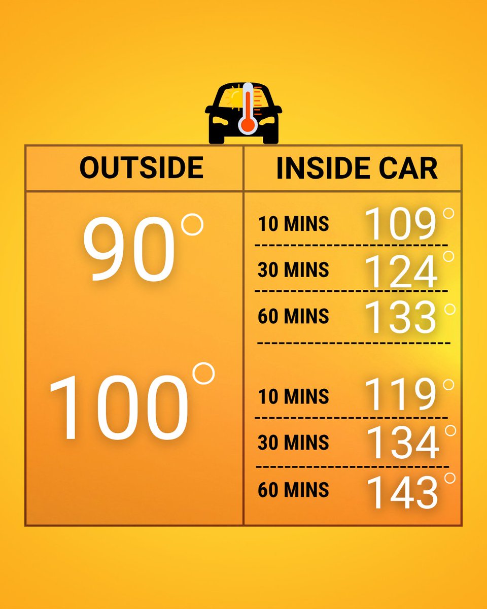
A sweltering heat wave is affecting millions of Americans this week. 🔥🌡️ Protect yourself — and your child in the back seat! It's NEVER safe to leave them alone in a vehicle. This is how quickly a car heats up. ⤵️

A sweltering heat wave is affecting millions of Americans this week. 🔥🌡️ Protect yourself — and your child in the back seat! It's NEVER safe to leave them alone in a vehicle. 

This is how quickly a car heats up. ⤵️
NWS Boston (@nwsboston) 's Twitter Profile Photo

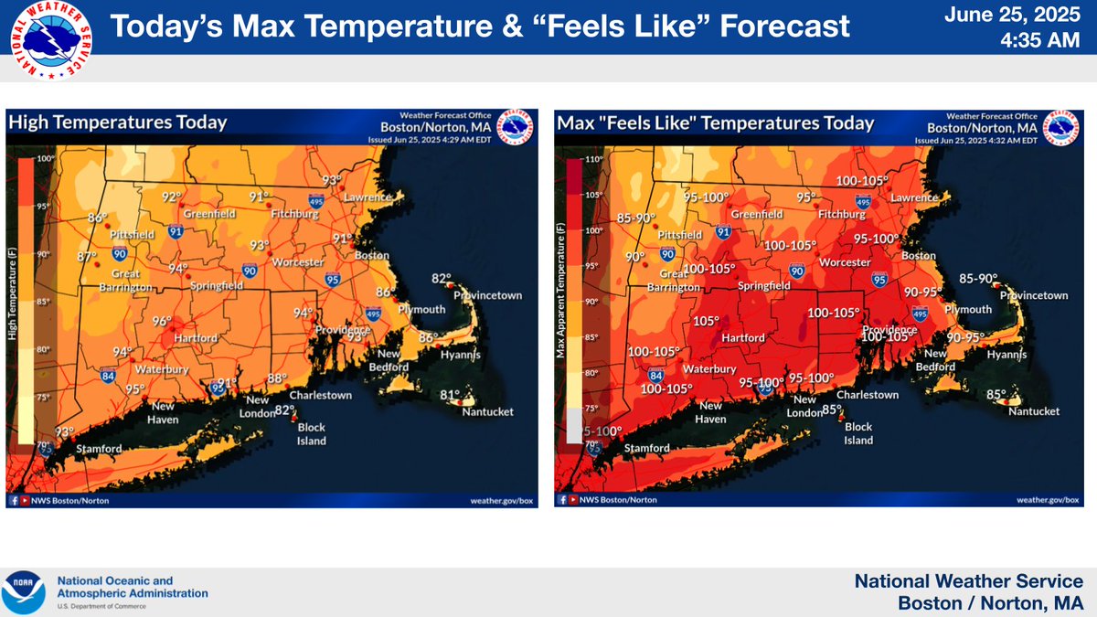
🌡️ A Heat Advisory is in effect through 7 PM today. Highs will reach the upper 80s to mid 90s for most, with 80s across the Cape and Islands. It’ll feel more like the 90s to near 100° with the humidity. Stay cool and take it easy if you’re outdoors #MAwx #RIwx #CTwx

🌡️ A Heat Advisory is in effect through 7 PM today. Highs will reach the upper 80s to mid 90s for most, with 80s across the Cape and Islands. It’ll feel more like the 90s to near 100° with the humidity. Stay cool and take it easy if you’re outdoors #MAwx #RIwx #CTwx