Hank Dolce (@hankd_wx) 's Twitter Profile
Hank Dolce

@hankd_wx

Master’s Student in the LSU @LSU_CCE Coastal Meteorology Lab | Texas A&M @tamu_atmo alum | Enjoyer of baroclinicity and ball | Native Texan

ID: 4832190758

linkhttps://www.linkedin.com/in/hank-dolce-209230229/ calendar_today29-01-2016 22:26:36

7,7K Tweet

1,1K Followers

1,1K Following

Avery Tomasco (@averytomascowx) 's Twitter Profile Photo

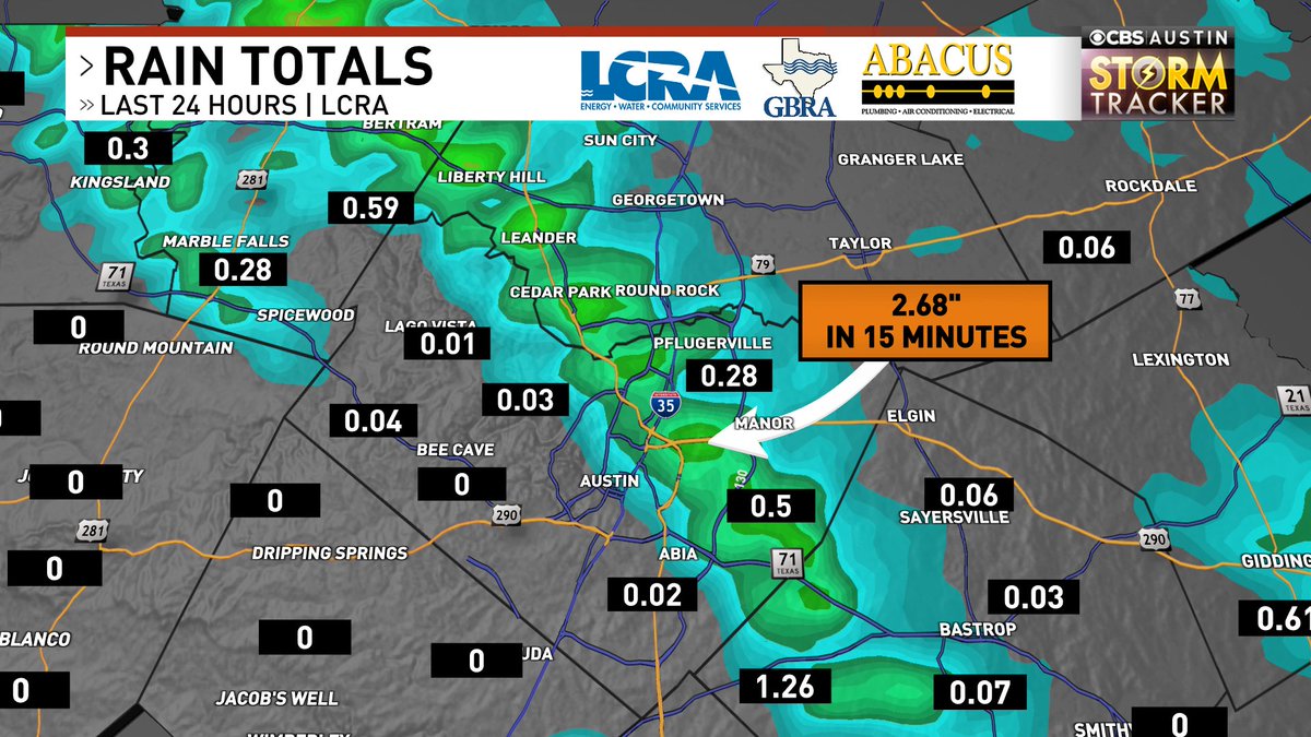
Someone correct me if I'm wrong, but a rain gauge in east Austin (near Webberville Rd) might have picked up one of the highest rainfall rates ever recorded. 2.68" was measured in 15 minutes at COA gauge 3310. That translates to an hourly rate of 10.72"/hr

Someone correct me if I'm wrong, but a rain gauge in east Austin (near Webberville Rd) might have picked up one of the highest rainfall rates ever recorded. 

2.68" was measured in 15 minutes at COA gauge 3310. That translates to an hourly rate of 10.72"/hr
Avery Tomasco (@averytomascowx) 's Twitter Profile Photo

This is it. *THE* video to watch from yesterday's destructive supercell. Credit to Iskra Mahler for catching it on his drone from east Austin. Edited to highlight: 1. Wall cloud over Austin with brief tornado attempt 2. Rare capture of a microburst 3. FFD ripping into the city

Hank Dolce (@hankd_wx) 's Twitter Profile Photo

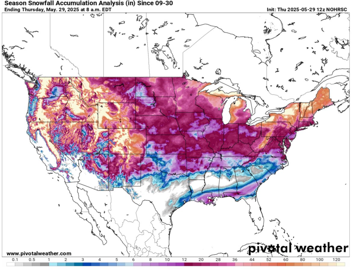
This is one of the most bizarre weather maps I’ve ever seen. Parts of the Gulf Coast received more snow this past winter than many areas in the Midwest and northern plains. New Orleans recorded twice as much snow on Jan. 21 than Southwestern North Dakota saw all winter. Like…?

This is one of the most bizarre weather maps I’ve ever seen. Parts of the Gulf Coast received more snow this past winter than many areas in the Midwest and northern plains. New Orleans recorded twice as much snow on Jan. 21 than Southwestern North Dakota saw all winter. Like…?
Paul Miller (@paulmillerwx) 's Twitter Profile Photo

Peak #Sahara #dust (~40 ug/m3), roughly ~5x the EPA max allowable yearly average, expected Fri-Sat in #BTR #lawx. Most recent simulations send core of dust further east #mswx #alwx #flwx. Check out dust work by LSU COMET Lab tinyurl.com/39pb4z6j LSU College of the Coast & Environment LSU Research

Hank Dolce (@hankd_wx) 's Twitter Profile Photo

My condolences to anyone who’s compiling WRF and running into errors that have no solutions found online. It just likes to be frustrating man

Nathaniel Tabor (@weathercast3) 's Twitter Profile Photo

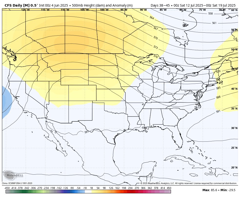
The way our upper air pattern is setting up this summer is reminding me more and more of 2021 as we go along. I’ve had this bunch for a while, but time will inevitably tell. For now though, very good look for rainfall/moderate temps in Texas going through July/August, unfortunate

The way our upper air pattern is setting up this summer is reminding me more and more of 2021 as we go along. I’ve had this bunch for a while, but time will inevitably tell. For now though, very good look for rainfall/moderate temps in Texas going through July/August, unfortunate
Hunter Williams (@hunt_wx) 's Twitter Profile Photo

The National Weather Service has released the full damage assessment of the May 28th supercell and microburst event in Austin. Shows the approximate location of the core microburst winds of 65 to 85 mph as well as the rear flank downdraft winds of 55 to 75 mph. NWS Austin/San Antonio
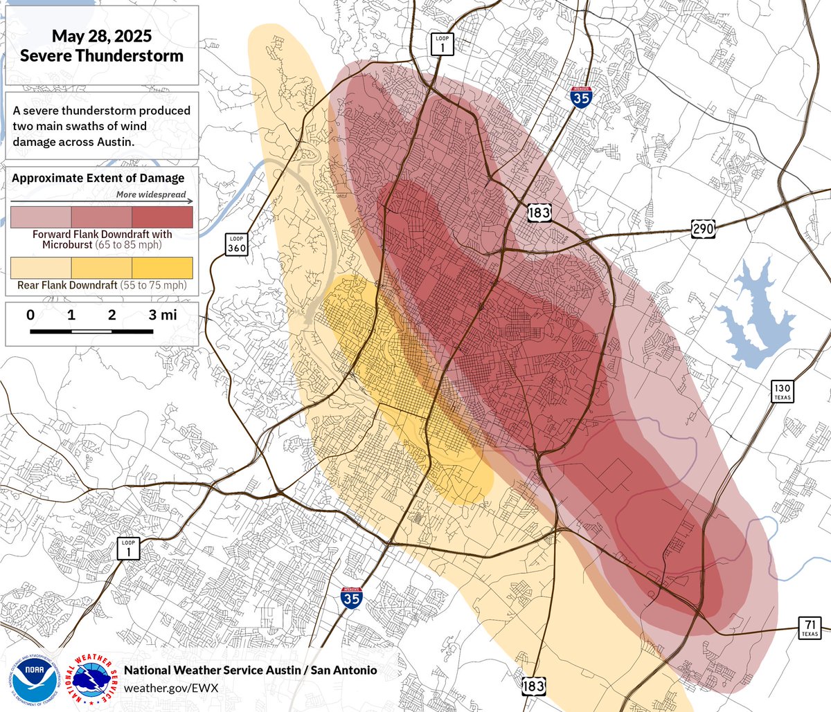
The National Weather Service has released the full damage assessment of the May 28th supercell and microburst event in Austin. Shows the approximate location of the core microburst winds of 65 to 85 mph as well as the rear flank downdraft winds of 55 to 75 mph. <a href="/NWSSanAntonio/">NWS Austin/San Antonio</a>
Andy Hazelton (@andyhazelton) 's Twitter Profile Photo

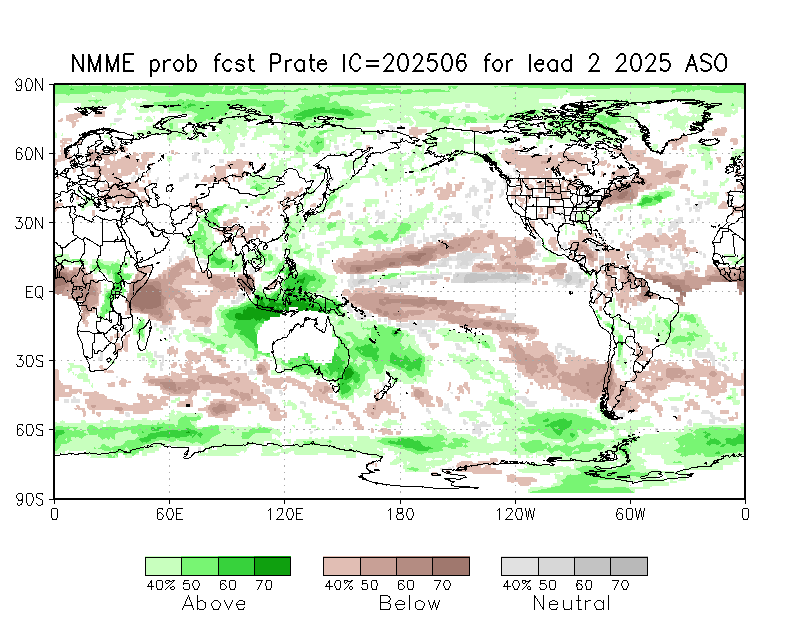
Latest NMME climate model mean shows cool neutral ENSO for peak season. In the Atlantic, warmest anomalies are in the subtropics, which will probably lead to stability and subsidence. Consistent with this are dry precip anomalies across much of the basin.

Latest NMME climate model mean shows cool neutral ENSO for peak season. In the Atlantic, warmest anomalies are in the subtropics, which will probably lead to stability and subsidence. Consistent with this are dry precip anomalies across much of the basin.
Paul Miller (@paulmillerwx) 's Twitter Profile Photo

Faint brown hue over LSU campus after #Saharan #dust moved in last night. Current particulates in #BTR are ~3x the EPA annual standard. We know it never rains in Tiger Stadium, but there will be plenty of #dust in #AlexBox during LSU Baseball's Super Regional. #lawx LSU College of the Coast & Environment
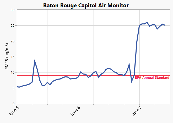
Faint brown hue over <a href="/LSU/">LSU</a> campus after #Saharan #dust moved in last night. Current particulates in #BTR are ~3x the EPA annual standard. We know it never rains in Tiger Stadium, but there will be plenty of #dust in #AlexBox during <a href="/LSUbaseball/">LSU Baseball</a>'s Super Regional. #lawx <a href="/LSU_CCE/">LSU College of the Coast & Environment</a>
Sydney Goldberg (@sydneygold_wx) 's Twitter Profile Photo

We'll have to keep an eye on radar today for Game 2 of the Baton Rouge Regional. Scattered afternoon showers & storms are possible, though timing and coverage varies by model. ⛈️ Some storms could be strong, producing gusty winds, heavy rain, and frequent lightning. #lawx

We'll have to keep an eye on radar today for Game 2 of the Baton Rouge Regional. Scattered afternoon showers &amp; storms are possible, though timing and coverage varies by model. ⛈️ Some storms could be strong, producing gusty winds, heavy rain, and frequent lightning. #lawx
Hank Dolce (@hankd_wx) 's Twitter Profile Photo

A very subtle reflectivity signature of emissions from the BR Exxon refinery tonight. Not too uncommon that you see these show up

Avery Tomasco (@averytomascowx) 's Twitter Profile Photo

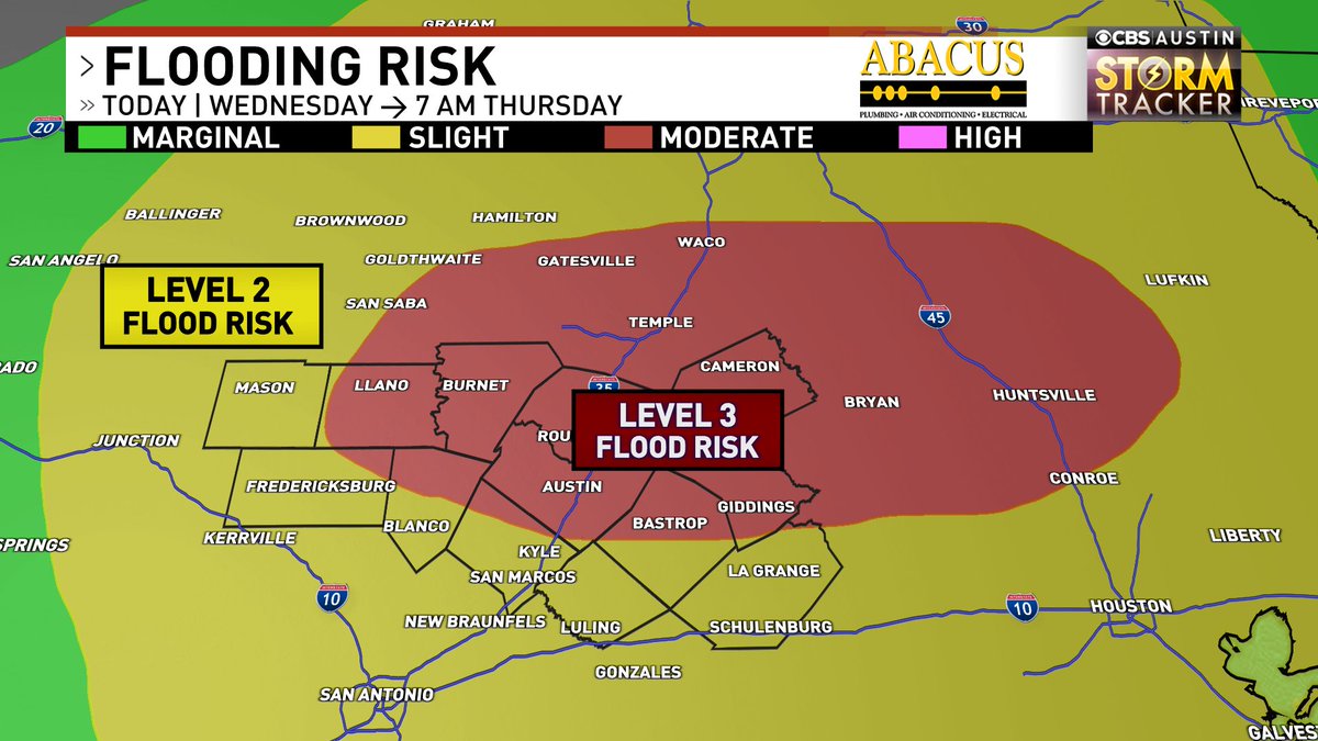
HEADS UP - Already a big soaking this morning, and with more storms on the way in the next 24 hours, the flood threat is ramping up. Now a level 3 out of 4 flood threat for Central Texas, including Austin. Been a LONG time since that has been issued locally #atxwx #txwx

HEADS UP - Already a big soaking this morning, and with more storms on the way in the next 24 hours, the flood threat is ramping up. 

Now a level 3 out of 4 flood threat for Central Texas, including Austin. Been a LONG time since that has been issued locally #atxwx #txwx