Giovanni Rizzotti (@gio_wx) 's Twitter Profile
Giovanni Rizzotti

@gio_wx

21 | VT Meteorology ‘26 | Tornado History/Damage Researcher | Rollercoaster Nerd | Hip Hop Guru | #RavensFlock | #Birdland | #SunsUp | #SeaKraken | Motorsports

ID: 770344046212546560

linkhttps://www.youtube.com/channel/UCEFrBbjLqGjSITlbTF2bxXw/featured?view_as=subscriber calendar_today29-08-2016 19:35:07

16,16K Tweet

2,2K Followers

2,2K Following

Giovanni Rizzotti (@gio_wx) 's Twitter Profile Photo

The tornado that occurred near Montezuma Creek, Utah on Saturday, September 13 has been rated EF-2, with winds of 120mph. This is the second significant tornado in Utah in 2025 and is also the strongest tornado on record in San Juan County, Utah. #UTwx

Giovanni Rizzotti (@gio_wx) 's Twitter Profile Photo

Woah! Tornado likely ongoing with this supercell southwest of Atolia, California in Kern County - tight couplet with 32.5kt VROT.

Woah! Tornado likely ongoing with this supercell southwest of Atolia, California in Kern County - tight couplet with 32.5kt VROT.
iembot_dmg (@iembot_dmg) 's Twitter Profile Photo

BIS issues Damage Survey PNS (Max: EF2) at Sep 18, 8:39 PM CDT ...NWS Damage Survey for September 14th 2025 Tornado Event Second Update... mesonet.agron.iastate.edu/p.php?pid=2025…

NWS Pueblo (@nwspueblo) 's Twitter Profile Photo

Thanks to Giovanni Rizzotti for pointing this out - we've been in contact with the Emergency Manager of Saguache County - right now, the damage is too remote to survey (~2 miles from any road / 11,200'), Saguache EM is currently trying to get a drone to conduct a damage survey. #COwx

JavaHurricane (@javahurricane) 's Twitter Profile Photo

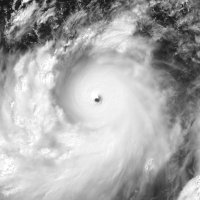
It is as I had feared. The next buoy observation, at 0803 UTC, reported a pressure of 900.3 mbar near the center (image credit: Sohum Chatterjee). #Ragasa (#NandoPH) is currently a sub-900 mbar super #typhoon, and recent MW data shows that its ongoing ERC is already nearly over.

It is as I had feared. The next buoy observation, at 0803 UTC, reported a pressure of 900.3 mbar near the center (image credit: <a href="/ChatterjeeSohum/">Sohum Chatterjee</a>). #Ragasa (#NandoPH) is currently a sub-900 mbar super #typhoon, and recent MW data shows that its ongoing ERC is already nearly over.

Giovanni Rizzotti (@gio_wx) 's Twitter Profile Photo

Appears a tornado just impacted the town of Brooksville, Kentucky. TDS on two different scans on the KILN radar. ZDR and reflectivity appear to correlate with height continuity.

Appears a tornado just impacted the town of Brooksville, Kentucky. TDS on two different scans on the KILN radar. ZDR and reflectivity appear to correlate with height continuity.
Jaden Pappenheim (@pappenheimwx) 's Twitter Profile Photo

Speechless. Unreal tornado just occurred on Torch Lake in Michigan. I was watching the webcam when it initially touched down lofting tree debris and quickly called the NWS in Gaylord. Hats off to them for getting the warning out in record time!

Speechless. Unreal tornado just occurred on Torch Lake in Michigan. I was watching the webcam when it initially touched down lofting tree debris and quickly called the NWS in Gaylord. Hats off to them for getting the warning out in record time!