Kurt Menke - @geomenke.bsky.social (@geomenke) 's Twitter Profile
Kurt Menke - @geomenke.bsky.social

@geomenke

Danish Resident 🇩🇰 | @SeptimaDK | FOSS4G user/advocate/educator | Author: Discover QGIS 3.x 2nd Ed. | Co-author:QGIS for Hydrological Applications 2nd Ed.

ID: 7159622

linkhttp://Septima.dk calendar_today29-06-2007 20:10:17

10,10K Tweet

8,8K Takipçi

1,1K Takip Edilen

Kurt Menke - @geomenke.bsky.social (@geomenke) 's Twitter Profile Photo

#30DayMapChallenge 2024 Day 16: Choropleth An animated series of choropleth maps showing potential beaver population by watershed for the North Woods - at three different scales. Maps made in #QGIS, animation made via #ffmpeg. #beavers

Kurt Menke - @geomenke.bsky.social (@geomenke) 's Twitter Profile Photo

#30DayMapChallenge 2024 Day 18: 3D Today a quick 3D animation of Sawatch Range (Collegiate) 14'ers I've climbed. These are in central Colorado. They range in height from 14,073' (4,289m) to 14,420 (4,395m). I used the QGIS 2ThreeJS plugin.

Wendy Shijia (@shijiawendy) 's Twitter Profile Photo

#30DayMapChallenge Typography Same tools and process as used in the last post: generating landscape model from LiDAR data and painting on the surface, along with geometry nodes animation in #Blender.

Kurt Menke - @geomenke.bsky.social (@geomenke) 's Twitter Profile Photo

#30DayMapChallenge 2024 Day 21: Conflict Deer-vehicle collisions in Denmark from 2003 - 2010. 8 years of data animated using the #QGIS Temporal Controller. Over this time period, there were 24,449 collisions for an average of a little more than 3,000 per year.

Kurt Menke - @geomenke.bsky.social (@geomenke) 's Twitter Profile Photo

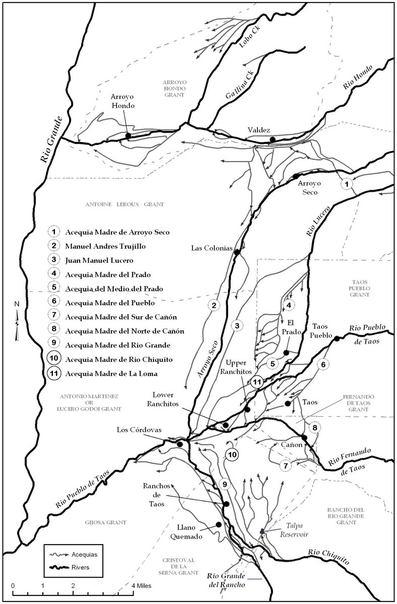
#30DayMapChallenge 2024 Day 22: Two Colors Today, I present a map made of the Taos Valley (New Mexico, USA) Spanish acequia network. #QGIS

#30DayMapChallenge 2024 Day 22: Two Colors
Today, I present a map made of the Taos Valley (New Mexico, USA) Spanish acequia network. #QGIS
Kurt Menke - @geomenke.bsky.social (@geomenke) 's Twitter Profile Photo

#30DayMapChallenge 2024 Day 23: Memory 12 years ago today, I climbed Mt. Shavano (14,229' - 4,337 m). In a typical year, this mountain can b covered in snow by late November, but 12 years ago, it was unseasonably warm. The hike was recorded with my Suunto GPS watch. #QGIS #Suunto

#30DayMapChallenge 2024 Day 23: Memory
12 years ago today, I climbed Mt. Shavano (14,229' - 4,337 m). In a typical year, this mountain can b covered in snow by late November, but 12 years ago, it was unseasonably warm. The hike was recorded with my Suunto GPS watch. #QGIS #Suunto
Kurt Menke - @geomenke.bsky.social (@geomenke) 's Twitter Profile Photo

#30DayMapChallenge 2024 Day 24: Only Circular Shapes Denmarks Population by Age Group per Municipality. The charts are sized by the area of each municipality. #QGIS

#30DayMapChallenge 2024 Day 24: Only Circular Shapes
Denmarks Population by Age Group per Municipality. The charts are sized by the area of each municipality. #QGIS
Tõnis Kärdi (@tkardi) 's Twitter Profile Photo

Good news! Just off a meeting with Marko, Stefanie Lumnitz , and Besfort Guri discussing the last(-ish) details for the #FOSS4GE2025 general program talks and workshops call-for-proposals. FOSS4G Europe 2025 is going to Mostar, Bosnia-Herzegovina, 14-20 July.

Good news! Just off a meeting with Marko, <a href="/stefanielumnitz/">Stefanie Lumnitz</a> , and <a href="/BGuri/">Besfort Guri</a>  discussing the last(-ish) details for the #FOSS4GE2025 general program talks and workshops call-for-proposals.

FOSS4G Europe 2025 is going to Mostar, Bosnia-Herzegovina, 14-20 July.
Kurt Menke - @geomenke.bsky.social (@geomenke) 's Twitter Profile Photo

#30DayMapChallenge 2024 Day 25: Heat Mean maximum temperature on a monthly basis from 1970-2020. Animated in QGIS. Data source: WorldClim 21.

Jürgen E. Fischer🇪🇺🇺🇦 (@juergenefischer) 's Twitter Profile Photo

Linux, Windows and Mac packages of new #QGIS release 3.40.1 "Bratislava" (new LTR) and point release 3.34.13 "Prizren" (old LTR) ready on qgis.org. Make maps not war!

Linux, Windows and Mac packages of new #QGIS  release 3.40.1 "Bratislava" (new LTR) and point release 3.34.13 "Prizren" (old LTR) ready on qgis.org. Make maps not war!
Kurt Menke - @geomenke.bsky.social (@geomenke) 's Twitter Profile Photo

#30DayMapChallenge 2024 Day 30: The Final Map I've spent a lot of time playing with Relative Elevation Models (REM's) recently. This is my favorite - The Wilamette River between Corvallis and Salem Oregon. I used the IDW method detailed by Dan Coe Carto. #QGIS

#30DayMapChallenge 2024 Day 30: The Final Map
I've spent a lot of time playing with Relative Elevation Models (REM's) recently. This is my favorite - The Wilamette River between Corvallis and Salem Oregon. I used the IDW method detailed by Dan Coe Carto.
#QGIS
Locate Press (@locatepress) 's Twitter Profile Photo

Our most recent book, Collecting Field Data with QGIS and Mergin Maps, has everything you need to harness the power of QGIS and the Mergin Maps platform. This book walks you through how to set up a project, configure survey layers, conduct a field survey, create maps, and more.

Alexandre Neto (@alexnetogeo) 's Twitter Profile Photo

Once upon a time, there was a man called Giovanni. He was a #QGIS power user and loved the software, but he had an itch… As any other main character of the traditional tales, instead of looking away, he decided to accept the quest and solve it. aneto.pt/posts/opinion/…