Geethen (@geethen1) 's Twitter Profile
Geethen

@geethen1

Postdoc @Stellenboschuni university.
Interested in applying AI to spatial data to address ecological challenges since 2017.
[email protected]

ID: 1260879236786728964

calendar_today14-05-2020 10:27:03

199 Tweet

164 Takipçi

270 Takip Edilen

Jan Pauls (@jan_pauls_) 's Twitter Profile Photo

Our paper "Estimating Canopy Height at Scale" has been accepted to #ICML24, where we significantly advance global canopy height mapping. w/ Max Zimmer, U. Kelly, M. Schwartz, S. Saatchi, Philippe.ciais , Sebastian Pokutta , Martin Brandt, F. Gieseke arxiv.org/abs/2406.01076 🧵 1/5
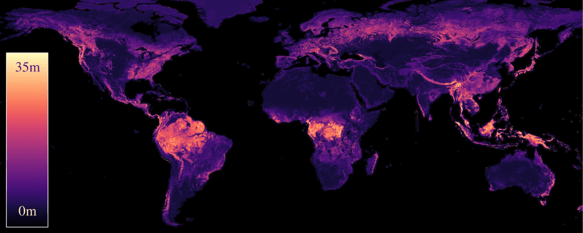
Our paper "Estimating Canopy Height at Scale" has been accepted to #ICML24, where we significantly advance global canopy height mapping.

w/ <a href="/maxzimmerberlin/">Max Zimmer</a>, U. Kelly, M. Schwartz, S. Saatchi, <a href="/ciais_philippe/">Philippe.ciais</a> , <a href="/spokutta/">Sebastian Pokutta</a> , <a href="/matin_brandt/">Martin Brandt</a>, F. Gieseke
arxiv.org/abs/2406.01076
🧵 1/5
Robin Cole (@robmarkcole) 's Twitter Profile Photo

👀Across all global maps, water was the most accurately mapped class (92%), followed by built area (83%), tree cover (81%) and crops (78%)

NASAEarthdata (@nasaearthdata) 's Twitter Profile Photo

Are you looking for #CO2 #emission data? Check out the new EMIT Level-2B Carbon Dioxide Enhancement and Level-2B Estimated Carbon Dioxide Plume Complexes 60 m data products at NASA's #LPDAAC! #GHG Access the new products: go.nasa.gov/4cqlSgT

Are you looking for #CO2 #emission data? Check out the new EMIT Level-2B Carbon Dioxide Enhancement and Level-2B Estimated Carbon Dioxide Plume Complexes 60 m data products at NASA's #LPDAAC!
#GHG 

Access the new products: go.nasa.gov/4cqlSgT
Sage K. Naidoo (@sageknaidoo) 's Twitter Profile Photo

Thrilled to share my first publication in Scientific Reports! Our study focused on comparing morphometric responses of two congeneric species, the native Cape and the non-native house sparrows to increased urbanisation in SA. Link: doi.org/10.1038/s41598…

Jakub Nowosad (@jakub_nowosad) 's Twitter Profile Photo

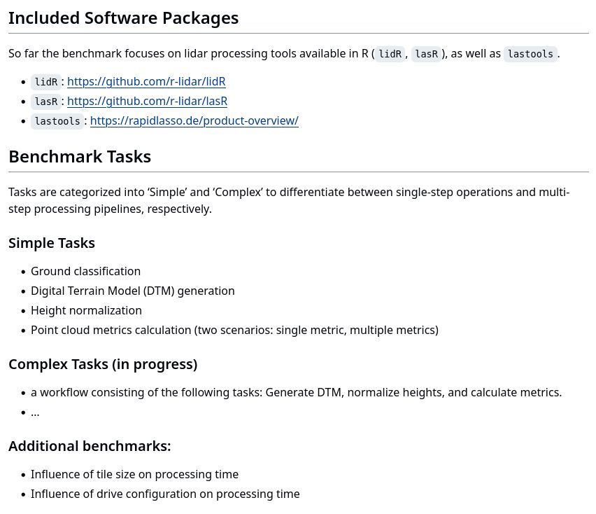
Piotr Tompalski recently started a project of evaluating the performance of various point cloud processing tools. You can find his ongoing results at buff.ly/4bYp1DX #rstats #lidar #lastools

Piotr Tompalski recently started a project of evaluating the performance of various point cloud processing tools.

You can find his ongoing results at buff.ly/4bYp1DX

#rstats #lidar #lastools
Sherrie Wang (@sherwang) 's Twitter Profile Photo

Remote sensing maps need uncertainty quantification to ensure they can be used reliably for science & policy. Excited to share our preprint on methods to correct map biases and quantify errors, bridging the gap between map creation and use: arxiv.org/abs/2407.13659  🗺❓🧵 1/n

Ujaval Gandhi (@spatialthoughts) 's Twitter Profile Photo

My take on the 'Anatomy of a Matplotlib Figure' for geospatial visualization. Check out the notebook that creates the plot using #matplotlib using fancyarrowpatch annotations. Feel free to use/adapt for your own teaching! courses.spatialthoughts.com/python-dataviz…

Qiusheng Wu (@giswqs) 's Twitter Profile Photo

🌍 Join our new Discord server! 💻 Discuss and collaborate on open-source #geospatial projects like geemap, leafmap, samgeo, and more. 👨‍💻 All are welcome. GitHub: github.com/opengeos Discord: discord.gg/UgZecTUq5P

🌍 Join our new Discord server! 💻 Discuss and collaborate on open-source #geospatial projects like geemap, leafmap, samgeo, and more. 👨‍💻 All are welcome.
GitHub: github.com/opengeos
Discord: discord.gg/UgZecTUq5P
Jeremy Howard (@jeremyphoward) 's Twitter Profile Photo

Announcing FastHTML. A new way to create modern interactive web apps. Scales down to a 6-line python file; scales up to complex production apps. Auth, DBs, caching, styling, etc built-in & replaceable and extensible. 1-click deploy to Railway, Vercel, Hugging Face, & more.

Announcing FastHTML. A new way to create modern interactive web apps.

Scales down to a 6-line python file; scales up to complex production apps.

Auth, DBs, caching, styling, etc built-in &amp; replaceable and extensible. 1-click deploy to <a href="/Railway/">Railway</a>, <a href="/vercel/">Vercel</a>, <a href="/huggingface/">Hugging Face</a>, &amp; more.
Stanford AI Lab (@stanfordailab) 's Twitter Profile Photo

arXiv -> alphaXiv Students at Stanford have built alphaXiv, an open discussion forum for arXiv papers. alphaXiv You can post questions and comments directly on top of any arXiv paper by changing arXiv to alphaXiv in any URL!

Rafael Izbicki (@rizbicki) 's Twitter Profile Photo

Our paper "Regression Trees for Fast and Adaptive Prediction Intervals," co-authored with Luben Miguel, @mpotto1 and Rafael Stern, is now published in Information Sciences! 🎉 We introduce Locart and Loforest to calibrate prediction intervals for regression with coverage guarantees. +


Our paper "Regression Trees for Fast and Adaptive Prediction Intervals," co-authored with <a href="/kuben45/">Luben Miguel</a>, @mpotto1 and <a href="/rbstern/">Rafael Stern</a>, is now published in Information Sciences! 🎉

We introduce Locart and Loforest to calibrate prediction intervals for regression with coverage guarantees. +
Ecography (@ecographyjourna) 's Twitter Profile Photo

Landsat-based greening trends in alpine ecosystems are inflated by multidecadal increases in summer observations nsojournals.onlinelibrary.wiley.com/doi/10.1111/ec… #Landsat #RemoteSensing #Greening Nordic Society Oikos Wiley Ecology & Evolution
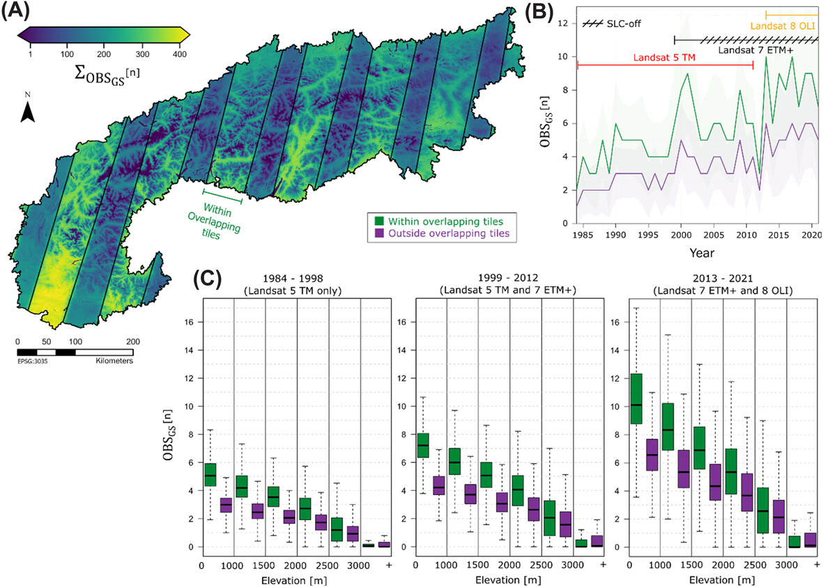
Landsat-based greening trends in alpine ecosystems are inflated by multidecadal increases in summer observations nsojournals.onlinelibrary.wiley.com/doi/10.1111/ec… #Landsat #RemoteSensing #Greening <a href="/NordicOikos/">Nordic Society Oikos</a> <a href="/WileyEcolEvol/">Wiley Ecology & Evolution</a>
Aravind 🌍 🛰 (@aravindeo) 's Twitter Profile Photo

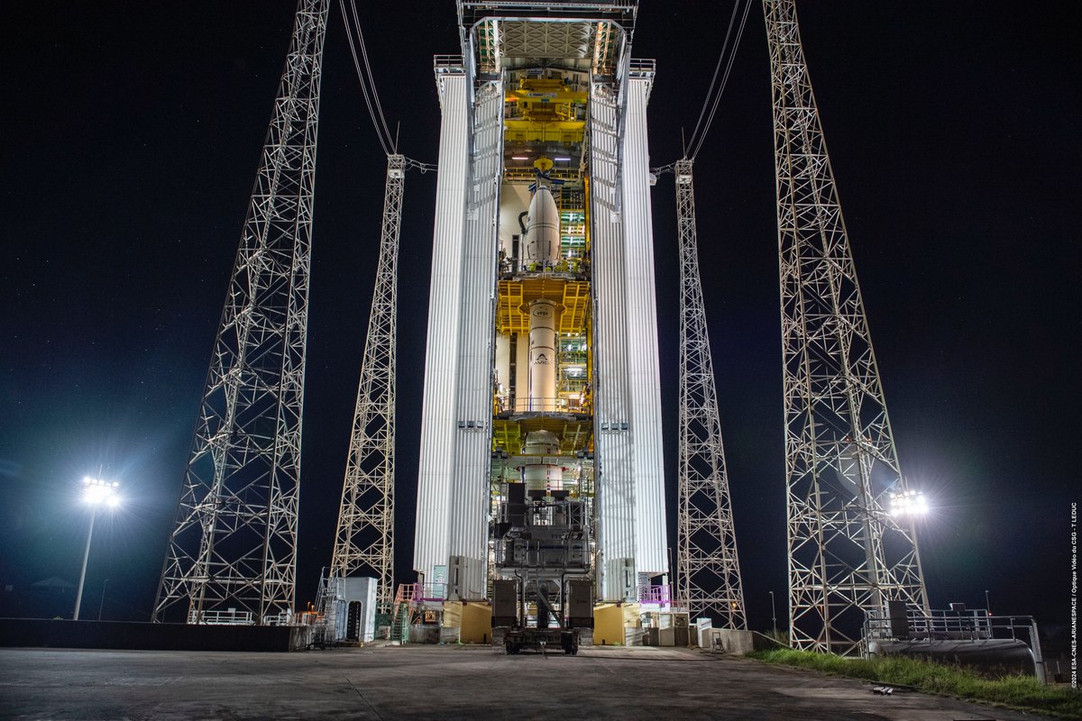
The Sentinel-2C satellite that should be launched tonight is expected to replace the Sentinel-2A satellite, which is, as far as I know, a perfectly healthy mission that is still performing well more than 9 years after launch. However, why should a successful launch of Sentinel-2C

The Sentinel-2C satellite that should be launched tonight is expected to replace the Sentinel-2A satellite, which is, as far as I know, a perfectly healthy mission that is still performing well more than 9 years after launch. However, why should a successful launch of Sentinel-2C
Hannah Kerner (@hannah_kerner) 's Twitter Profile Photo

Fields of The World is an open-source project (links below). We hope to grow the dataset in the future with community contributions. 📄 arxiv.org/abs/2409.16252 🌐 fieldsofthe.world Data beta.source.coop/kerner-lab/fie… Code github.com/fieldsofthewor… Requests github.com/fieldsofthewor…

Katarzyna Ewa Lewińska @kelewinska.bsky.socia (@kelewinska) 's Twitter Profile Photo

We all think we know how much #Landsat and #Sentinel-2 data is in the archives🛰️ 🌍Global edition 🚨See our new paper and dataset to check 1982-2023 data availability for your study site: tinyurl.com/yc82epfx #GEE data viewer: tinyurl.com/322e63p2 david frantz dfrantz.bsky.social Earth Observation Lab

Ujaval Gandhi (@spatialthoughts) 's Twitter Profile Photo

New Post: Tiling Large Exports in Google #EarthEngine with best practices on creating perfectly aligned mosaics from large images - featuring advanced concepts around projections, crs transform, resampling and nodata masks spatialthoughts.com/2024/10/23/lar…

Ribana Roscher (@ribanaroscher) 's Twitter Profile Photo

🚨Our new review paper "Better, not just more: Data-centric ML for Earth Observation" 🌐🤖🛰️🔍 has finally been published in GRSM. Shifting the focus from models to data offers new possibilities to improve accuracy, generalization, and real-world impact: ieeexplore.ieee.org/document/10740…

🚨Our new review paper "Better, not just more: Data-centric ML for Earth Observation" 🌐🤖🛰️🔍 has finally been published in GRSM. Shifting the focus from models to data offers new possibilities to improve accuracy, generalization, and real-world impact: ieeexplore.ieee.org/document/10740…
Geethen (@geethen1) 's Twitter Profile Photo

A new research paper investigating the distribution shifts of an invasive fern under climate change. sciencedirect.com/science/articl… My PhD thesis on applying machine learning to remote sensing data for managing water hyacinth: wiredspace.wits.ac.za/server/api/cor…

Land & Carbon Lab (@landcarbonlab) 's Twitter Profile Photo

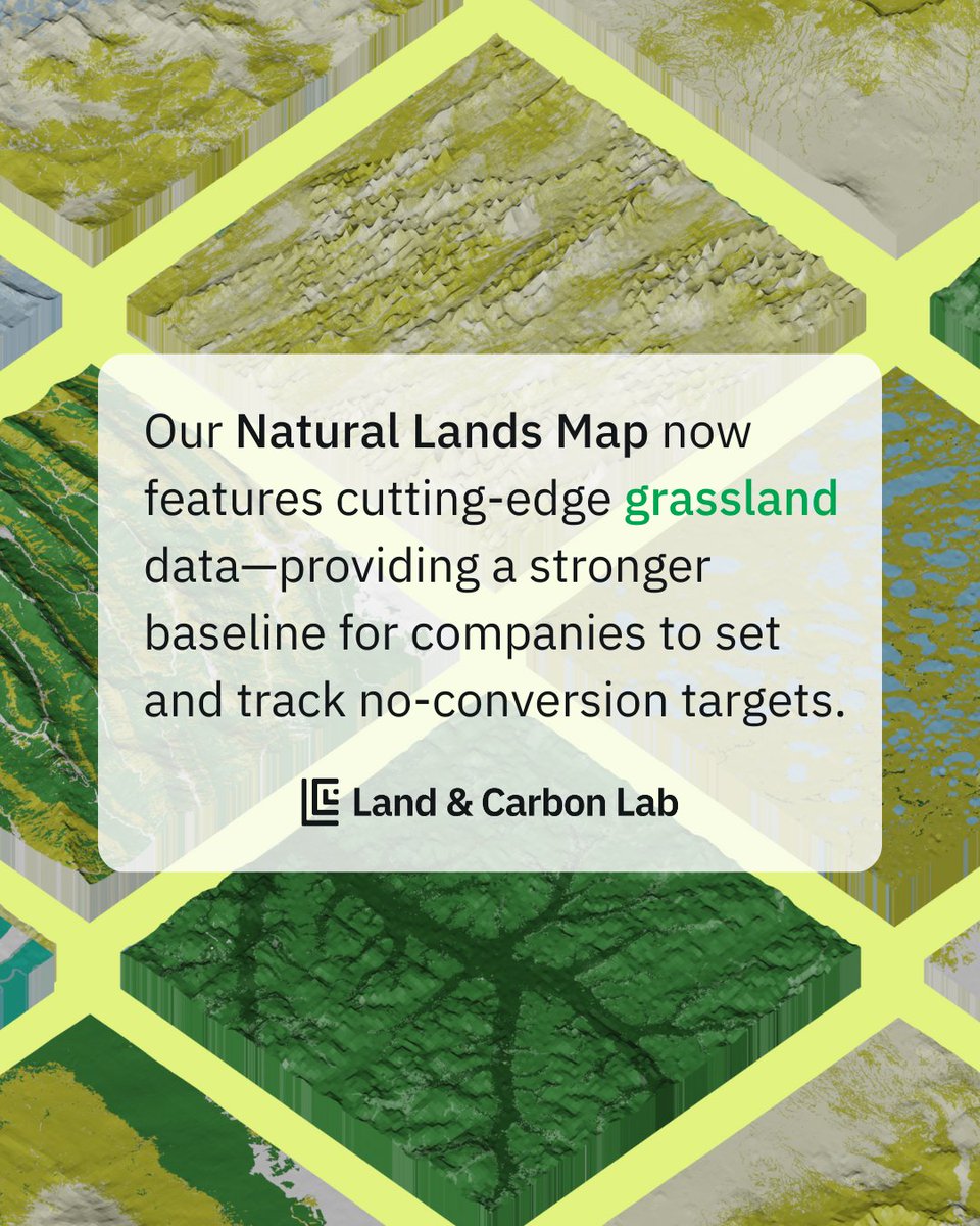
🚨 UPDATE: Version 1.1 of the Natural Lands Map now includes cutting-edge grassland data, filling a critical gap in how companies track their impact. ➡️ Learn more: bit.ly/4k3jLEa ➡️ Explore the data: bit.ly/4b6l6pv

🚨 UPDATE: Version 1.1 of the Natural Lands Map now includes cutting-edge grassland data, filling a critical gap in how companies track their impact. 

➡️ Learn more: bit.ly/4k3jLEa 
➡️ Explore the data: bit.ly/4b6l6pv
Qiusheng Wu (@giswqs) 's Twitter Profile Photo

🎉 The recording of the first session of our Open Science Workshop series is now live! 📺 Watch it on YouTube: youtube.com/live/sh5iPQRVd… 🔍 Don’t miss our next workshop on Open Data happening March 24! Stay updated here: tiny.utk.edu/openscience #opencescience #coding #python