
FEMA Region 7 (@femaregion7) 's Twitter Profile
FEMA Region 7

@femaregion7

FEMA Region 7 - Features FEMA mission-related info. For emergencies, call local fire/EMS/police or 9-1-1. Serving IA, KS, MO, NE. #preplist, #MidwestReady

ID: 18487299

linkhttps://www.fema.gov/about/organization/region-7 calendar_today30-12-2008 20:28:14

10,10K Tweet

19,19K Followers

791 Following

Nebraska Emergency Management Agency (@nematweets) 's Twitter Profile Photo

➡️Burning is prohibited through midnight May 10 due to the potential wildfire risk. The executive order specifies the border. The line runs south along U.S. Hwy 81 from the South Dakota border to Hwy 92. The line then goes west to U.S. Hwy 281 & runs south to the Kansas border.

➡️Burning is prohibited through midnight May 10 due to the potential wildfire risk.

The executive order specifies the border. The line runs south along U.S. Hwy 81 from the South Dakota border to Hwy 92. The line then goes west to U.S. Hwy 281 & runs south to the Kansas border.
Missouri State Emergency Management Agency (@mosema_) 's Twitter Profile Photo

A Multi-Agency Resource Center will take place Saturday, May 3 in Delta, MO for those impacted by the severe storms and tornadoes that occurred between March 30 and April 8. If you are still in need of assistance, please be sure to stop by!

A Multi-Agency Resource Center will take place Saturday, May 3 in Delta, MO for those impacted by the severe storms and tornadoes that occurred between March 30 and April 8. If you are still in need of assistance, please be sure to stop by!
FEMA Region 7 (@femaregion7) 's Twitter Profile Photo

🔥Grassland & wildfires can spread rapidly. Make sure your #prep plan includes more than 1 way to escape. Always follow local rules re: open burning. More tips: fema.gov/blog/4-tips-pr… smokeybear.com/en/prevention-… #newx #kswx #iawx #mowx #wildfire FEMA

FEMA Region 7 (@femaregion7) 's Twitter Profile Photo

🔥 #NE! Fire danger Sun 5/11/25. State officials warn that burning is NOT allowed under these conditions. #BeReady. Monitor surroundings & make sure to have 2 routes to evacuate if a fire breaks out. It's dry out there! #newx #wildfire @NEMATweets FEMA #sdwx

FEMA Region 7 (@femaregion7) 's Twitter Profile Photo

⛈️ Iowa! Severe storms expected tonight & early Thurs. (5/15). Have multiple ways to wake up to alerts during the night AND know where to shelter if needed. 'Tis the season. 😬 #iawx IowaHSEM Iowa Emergency Management Association #IA #BeReady FEMA

FEMA Region 7 (@femaregion7) 's Twitter Profile Photo

❗️#NE. It's going to be a dark & stormy Wed. night (5/14) so #BeReady before your head hits the pillow. ☑️ Shoes @ bedside ☑️ Multiple ways to receive & wake up to weather alerts ☑️ Flashlight(s) ☑️ Safe place to shelter (review w/everyone) #newx #iawx FEMA @NEMATweets

FEMA Region 7 (@femaregion7) 's Twitter Profile Photo

‼️ Storms coming!! Today (5/16) kicks off multiple days of hazardous weather. St. Louis + SEMO at high risk. Plan NOW for how you will: ⚡️Get weather alerts ⚡️Safely shelter ⚡️Safely travel ⚡️Stay in touch w/family, friends ⚡️Stay informed #mowx #stlwx #kywx #ilwx #arwx

‼️ Storms coming!! Today (5/16) kicks off multiple days of hazardous weather.  St. Louis + SEMO at high risk.  Plan NOW for how you will: 
⚡️Get weather alerts
⚡️Safely shelter 
⚡️Safely travel 
⚡️Stay in touch w/family, friends
⚡️Stay informed 
#mowx #stlwx #kywx #ilwx #arwx
FEMA Region 7 (@femaregion7) 's Twitter Profile Photo

‼️#MO! Fri. storms firing up & on the move. Weather pros warning of HAIL up to 🥎SOFTBALL size + high winds. Closely follow watches/warnings as conditions can change. #BeReady to protect yourself inside, outside or driving. St Louis County Office of Emergency Management #mowx #midmowx #stlwx #arwx #ilwx #kywx

‼️#MO!  Fri. storms firing up &amp; on the move. Weather pros warning of HAIL up to 🥎SOFTBALL size + high winds. Closely follow watches/warnings as conditions can change. #BeReady to protect yourself inside, outside or driving. <a href="/StlCoOEM/">St Louis County Office of Emergency Management</a> 
#mowx #midmowx #stlwx #arwx #ilwx #kywx
FEMA Region 7 (@femaregion7) 's Twitter Profile Photo

💔 A terrible Friday for metro St. Louis, Scott County, MO & beyond. Loss of life & severe storm damage has been reported. #STL officials are asking the public to: 🔸Stay out of impacted areas 🔸Limit cell phone use 🔸Use 9-1-1 for emergencies only #mowx #stlwx #ilwx

💔 A terrible Friday for metro St. Louis, Scott County, MO &amp; beyond. Loss of life &amp; severe storm damage has been reported.  
#STL officials are asking the public to:  
🔸Stay out of impacted areas 
🔸Limit cell phone use 
🔸Use 9-1-1 for emergencies only
#mowx #stlwx #ilwx
FEMA Region 7 (@femaregion7) 's Twitter Profile Photo

‼️#KS & #NE! Severe storm threat Sun 5/18 afternoon ➡️evening. Take seriously & #BeReady to act quickly. Large hail expected; KS = possible tornadoes. 🚗 Limit travel ❗️ Have multiple ways to get alerts, even overnight 😴 Prepare to shelter day/night #kswx #newx #mowx #iawx

‼️#KS &amp; #NE!  Severe storm threat Sun 5/18 afternoon ➡️evening. Take seriously &amp; #BeReady to act quickly. Large hail expected; KS = possible tornadoes. 
🚗 Limit travel
❗️ Have multiple ways to get alerts, even overnight
😴 Prepare to shelter day/night 
#kswx #newx #mowx #iawx
FEMA Region 7 (@femaregion7) 's Twitter Profile Photo

‼️NOW‼️Severe weather moving across #KS & #NE. Multiple watches & warnings being issued incl. for tornadoes. #BeReady to shelter. Follow weather pros for latest. ⬇️ NWS Hastings @NWSSevereTStorm @NWSTornado NWS Topeka NWS Goodland NWS Omaha #kswx #newx #mowx #iawx Trooper Ben
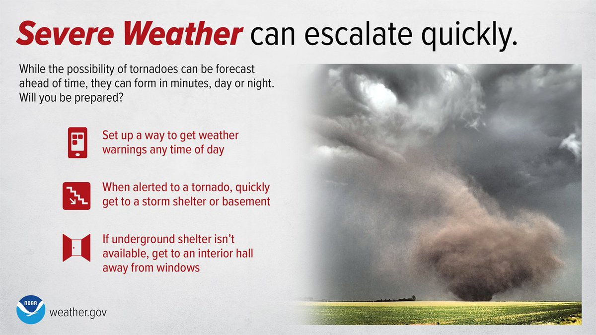
‼️NOW‼️Severe weather moving across #KS &amp; #NE. Multiple watches &amp; warnings being issued incl. for tornadoes. #BeReady to shelter. Follow weather pros for latest. ⬇️
<a href="/NWSHastings/">NWS Hastings</a> @NWSSevereTStorm @NWSTornado <a href="/NWSTopeka/">NWS Topeka</a> <a href="/NWSGoodland/">NWS Goodland</a> <a href="/NWSOmaha/">NWS Omaha</a> 
#kswx #newx #mowx #iawx <a href="/TrooperBenKHP/">Trooper Ben</a>
FEMA Region 7 (@femaregion7) 's Twitter Profile Photo

‼️3 pm CDT Mon. 5/19 - Numerous severe T-storm & tornado warnings are being issued for #KS #NE & #MO this aft. into evening. Be #WeatherAware. ID a safe place to shelter. 📱Follow weather pros closely. Know what to do at night 🔦 in an emergency. #kswx #mowx #newx #iawx

Missouri State Emergency Management Agency (@mosema_) 's Twitter Profile Photo

‼️⚠️Flash flooding in southern MO has led to water rescues and washed out low-water crossings and damaged bridges. ⚠️Nighttime flooding is particularly dangerous because of low visibility. Go slow! ⚠️Never drive into a flooded road! ⚠️More rain is coming. Watch for #MoWx updates

FEMA Region 7 (@femaregion7) 's Twitter Profile Photo

⚠️#BeReady for possible flooding in SW #MO thru Memorial Day. Watch forecasts. Have a plan for safe travel/evacuation if you are in the area. Don't walk or drive through floodwaters. Your 🚗car is not a boat! #mowx #spgwx #flood Missouri State Emergency Management Agency #WeatherAware

St Louis County Office of Emergency Management (@stlcooem) 's Twitter Profile Photo

📢 SBA Disaster Loans Available for St. Louis County after the March 14–15 storms 🌪️ 🏠 Homeowners/Renters 🏢 Businesses 🙏 Nonprofits 🗓️ Deadlines: Physical: 7/21/25 Economic: 2/23/26 💻 lending.sba.gov 📞 1-800-659-2955 📩 [email protected]

📢 SBA Disaster Loans Available for St. Louis County after the March 14–15 storms 🌪️

🏠 Homeowners/Renters
🏢 Businesses
🙏 Nonprofits

🗓️ Deadlines:

Physical: 7/21/25
Economic: 2/23/26

💻 lending.sba.gov
📞 1-800-659-2955
📩 disastercustomerservice@sba.gov
Missouri State Emergency Management Agency (@mosema_) 's Twitter Profile Photo

‼️Missouri State Emergency Management Agency is working with FEMA Region 7 & St. Louis Fire Dept to assess damage to public infrastructure and calculating the amount of debris that must be removed in St. Louis & other communities impacted by the severe storms on May 16. This data will be used to seek additional FEMA aid.
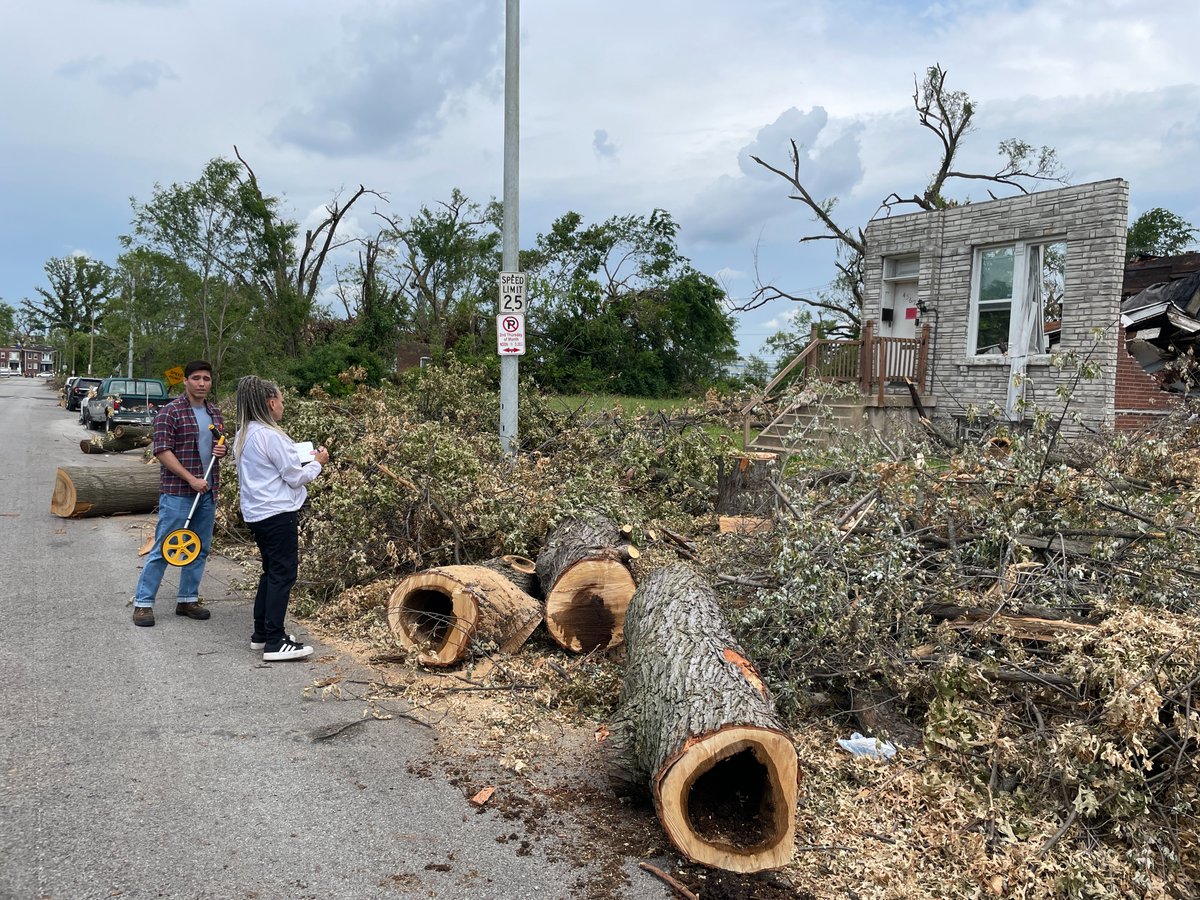
‼️<a href="/MoSEMA_/">Missouri State Emergency Management Agency</a> is working with <a href="/femaregion7/">FEMA Region 7</a> &amp; <a href="/STLFireDept/">St. Louis Fire Dept</a> to assess damage to public infrastructure and calculating the amount of debris that must be removed in St. Louis &amp; other communities impacted by the severe storms on May 16. This data will be used to seek additional FEMA aid.
NWS Wichita (@nwswichita) 's Twitter Profile Photo

A few severe storms will be possible this afternoon as a frontal boundary moves south and east over the area. Damaging winds up to 70 mph and hail up to the size of quarters will be possible. If you have outdoor plans today, make sure to stay weather aware. #KSwx

A few severe storms will be possible this afternoon as a frontal boundary moves south and east over the area. Damaging winds up to 70 mph and hail up to the size of quarters will be possible. If you have outdoor plans today, make sure to stay weather aware. #KSwx
FEMA Region 7 (@femaregion7) 's Twitter Profile Photo

👍MO! FEMA disaster assistance specialists out today (Sat. 5/31) to help register Missourians affected by March 14-15 storms for FEMA assistance. More dates/locations TBA. Follow us here. You can also register at disasterassistance.gov or by calling 1-800-621-3362. #mowx

👍MO! <a href="/fema/">FEMA</a> disaster assistance specialists out today (Sat. 5/31) to help register Missourians affected by March 14-15 storms for FEMA assistance. More dates/locations TBA. Follow us here. You can also register at disasterassistance.gov or by calling 1-800-621-3362. 
#mowx