eweather (@eweather13) 's Twitter Profile
eweather

@eweather13

Forecasts-Photography-Community. Download the free app today! When you seeweather, eweather! #CTwx #RIwx #MAwx #CTRiver #BlockIsland 📷🛥✈️🍷🍺⛷🚴🏿🌅

ID: 1607214534

linkhttp://www.eweatherapp.com calendar_today20-07-2013 02:29:59

97,97K Tweet

27,27K Takipçi

779 Takip Edilen

Scott Dunlop (@sdoppler2) 's Twitter Profile Photo

‘Touchin' down in New England town. Feel the heat comin' down… I've got to keep on keepin' on, You know the, big wheel keeps on spinnin' around’ 🎶✈️🌔 -Paul Pena / Steve Miller

‘Touchin' down in New England town.
Feel the heat comin' down…
I've got to keep on keepin' on,
You know the, big wheel keeps on spinnin' around’ 🎶✈️🌔
-Paul Pena / Steve Miller
eweather (@eweather13) 's Twitter Profile Photo

The beautiful streets of Bordeaux France this morning! Excessive heat warning in place. High of 105° expected today! 🥵

The beautiful streets of Bordeaux France this morning!

Excessive heat warning in place. High of 105° expected today! 🥵
eweather (@eweather13) 's Twitter Profile Photo

🌀 Erin Becomes the First Hurricane of the 2025 Atlantic Season. Location: 18.2N 56.1W; About 460 mi (740 km) east of the Northern Leeward Islands Maximum sustained winds: 75 mph (120 km/h) Present movement: WNW or 290 degrees at 18 mph (30 km/h) Minimum central pressure: 996

🌀 Erin Becomes the First Hurricane of the 2025 Atlantic Season. 

Location: 18.2N 56.1W; About 460 mi (740 km) east of the Northern Leeward Islands
Maximum sustained winds: 75 mph (120 km/h)
Present movement: WNW or 290 degrees at 18 mph (30 km/h)
Minimum central pressure: 996
eweather (@eweather13) 's Twitter Profile Photo

Thankfully the pool is still open after the call to end pool season late July. I’m coming off a 4 day heat wave this past week and to round out the other 3 days, all were over 85°. Perfect pool weather. Yes, next week turns much more refreshing. Great night swimming with the

eweather (@eweather13) 's Twitter Profile Photo

Good Evening! SE areas are still humid….inland north and west much better. Watch for areas of fog to develop overnight, especially toward SE coastal areas. Temps tonight range from the mid 50s north to the mid 60s south. Tomorrow…moderate levels of humidity….better as you

Good Evening! 

SE areas are still humid….inland north and west much better. Watch for areas of fog to develop overnight, especially toward SE coastal areas. Temps tonight range from the mid 50s north to the mid 60s south. 

Tomorrow…moderate levels of humidity….better as you
eweather (@eweather13) 's Twitter Profile Photo

Hurricane Erin is expected to rapidly strengthen this weekend. A major hurricane is expected to be between the US and Bermuda by mid next week. This may make it to a category 4 hurricane. As it strengthens it will grow in size too. It becomes a massive storm in the Atlantic -

Hurricane Erin is expected to rapidly strengthen this weekend. A major hurricane is expected to be between the US and Bermuda by mid next week. This may make it to a category 4 hurricane. As it strengthens it will grow in size too. It becomes a massive storm in the Atlantic -
eweather (@eweather13) 's Twitter Profile Photo

Boaters….no issues through the weekend other than patchy fog. 2s tomorrow….2-3s Sunday across nearshore waters including Block Island Sound. The next chance for a small craft advisory is Monday as NE winds will kick up behind the Sunday night front. 2-4s and shorter duration of

Boaters….no issues through the weekend other than patchy fog. 2s tomorrow….2-3s Sunday across nearshore waters including Block Island Sound. The next chance for a small craft advisory is Monday as NE winds will kick up behind the Sunday night front. 2-4s and shorter duration of
eweather (@eweather13) 's Twitter Profile Photo

And it’s good! Sunrise this morning perfectly through the uprights of The Pont Jacques Chaban-Delmas vertical-lift bridge over the Garonne in Bordeaux, France.

And it’s good!

Sunrise this morning perfectly through the uprights of The Pont Jacques Chaban-Delmas vertical-lift bridge over the Garonne in Bordeaux, France.
National Hurricane Center (@nhc_atlantic) 's Twitter Profile Photo

Aug 16: Images from NOAA Aircraft Operations Center and the NOAA Satellites Ocean Winds team show an intense eyewall in Hurricane #Erin This photo shows the ocean surface calm in the eye and roaring in the eyewall. For the latest forecast visit hurricanes.gov
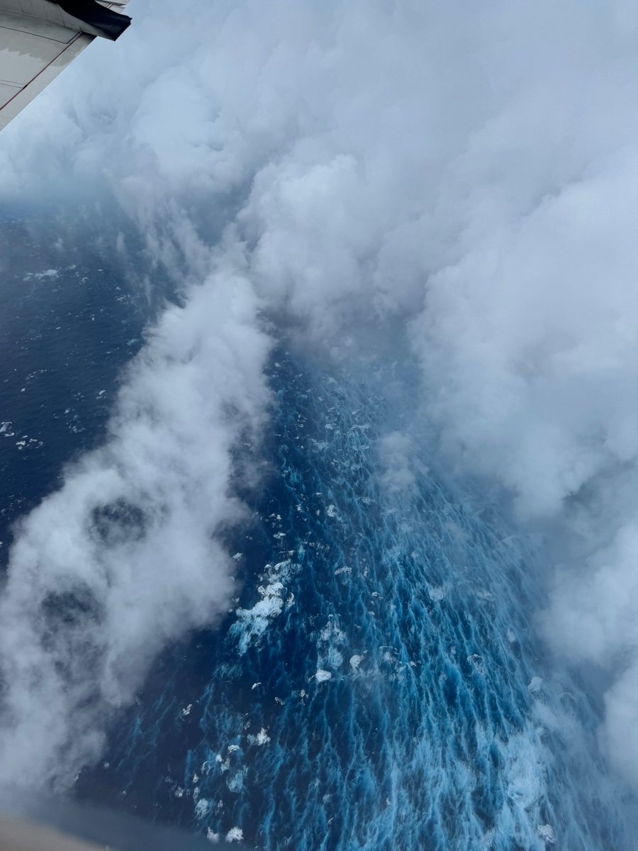
Aug 16: Images from <a href="/NOAA_HurrHunter/">NOAA Aircraft Operations Center</a> and the <a href="/NOAASatellites/">NOAA Satellites</a> Ocean Winds team show an intense eyewall in Hurricane #Erin This photo shows the ocean surface calm in the eye and roaring in the eyewall. For the latest forecast visit hurricanes.gov
eweather (@eweather13) 's Twitter Profile Photo

🌀 Erin has exploded to a category 5 hurricane with maximum sustained winds of 155mph! The rapid intensification was expected but surpassed all expectations. Just explosive development today. The good news, no changes in the ideas and this is still expected to pass between

🌀 Erin has exploded to a category 5 hurricane with maximum sustained winds of 155mph! 

The rapid  intensification was expected but surpassed all expectations. Just explosive development today. The good news, no changes in the ideas and this is still expected to pass between
eweather (@eweather13) 's Twitter Profile Photo

Good evening! Another quick update…a couple stray showers or storms continue into this evening favoring areas north and west. Then partly cloudy and muggy tonight with patchy fog developing. A mix of clouds and sun tomorrow. Hot and humid. Mid 80s to low 90s inland. Low to

Good evening! 

Another quick update…a couple stray showers or storms continue into this evening favoring areas north and west. Then partly cloudy and muggy tonight with patchy fog developing. 

A mix of clouds and sun tomorrow. Hot and humid. Mid 80s to low 90s inland. Low to
eweather (@eweather13) 's Twitter Profile Photo

No changes to the forecast today. Warmer and more humid with scattered showers and storms popping later today and tonight. A slight chance there can be a severe storm, but they now look most likely SW of SNE. BTW…mariners be aware there is a small craft advisory starting today

No changes to the forecast today. Warmer and more humid with scattered showers and storms popping later today and tonight. A slight chance there can be a severe storm, but they now look most likely SW of SNE. 

BTW…mariners be aware there is a small craft advisory starting today
eweather (@eweather13) 's Twitter Profile Photo

🌀 Erin still a major hurricane but winds are down to 125 mph. Strength typically fluctuates in these strong hurricanes, but it is still expected to be a major for the next several days. No changes to the ideas… Erin should pass about halfway between The Outer Banks of North

🌀 Erin still a major hurricane but winds are down to 125 mph. Strength typically fluctuates in these strong hurricanes, but it is still expected to be a major for the next several days. No changes to the ideas… Erin should pass about halfway between The Outer Banks of North
eweather (@eweather13) 's Twitter Profile Photo

Good Evening! A cold front is located NW of SNE now with a few showers and storms scattered out ahead of it. This front moves through the area tonight and with it a few more showers and storms possible tonight pushing through to the SE. SW winds at the shore will abruptly

Good Evening! 

A cold front is located NW of SNE now with a few showers and storms scattered out ahead of it. This front moves through the area tonight and with it a few more showers and storms possible tonight pushing through to the SE. SW winds at the shore will abruptly
eweather (@eweather13) 's Twitter Profile Photo

00z GFS spreads out those winds north and west as Erin expands moving north and the pressure gradient builds between the high pressure to the north. Official NWS marine forecast now calling for 9-13’ seas in Block Island Sound Thursday with NE gusts up to 30 knots.

00z GFS spreads out those winds north and west as Erin expands moving north and the pressure gradient builds between the high pressure to the north. 

Official NWS marine forecast now calling for 9-13’ seas in Block Island Sound Thursday with NE gusts up to 30 knots.
eweather (@eweather13) 's Twitter Profile Photo

Good Evening. What a refreshing day today with below average temps for a change and crisp air. A mostly clear and cool night coming up tonight with lows in the lower 50s for most. Still a decent looking week coming up…the hiccup is Wednesday which is trending a bit wetter.

Good Evening. 

What a refreshing day today with below average temps for a change and crisp air. A mostly clear and cool night coming up tonight with lows in the lower 50s for most. 

Still a decent looking week coming up…the hiccup is Wednesday which is trending a bit wetter.