Esri (@esri) 's Twitter Profile
Esri

@esri

Esri builds #ArcGIS, the leading location intelligence and spatial analytics software for mapping, 3D GIS, imagery, and geospatial app development.

ID: 16132791

linkhttps://www.esri.com/ calendar_today04-09-2008 18:19:09

20,20K Tweet

190,190K Followers

66,66K Following

Esri (@esri) 's Twitter Profile Photo

π˜›π˜¦π˜­π˜­π˜ͺ𝘯𝘨 𝘚𝘡𝘰𝘳π˜ͺ𝘦𝘴 𝘸π˜ͺ𝘡𝘩 π˜”π˜’π˜±π˜΄ uses Allen Carroll’s unique experiences working at National Geographic and Esri to explain the theory and practice of creating compelling, engaging place-based narratives. πŸ”ΈSee sample pages: ow.ly/6uzP50VNfuW

π˜›π˜¦π˜­π˜­π˜ͺ𝘯𝘨 𝘚𝘡𝘰𝘳π˜ͺ𝘦𝘴 𝘸π˜ͺ𝘡𝘩 π˜”π˜’π˜±π˜΄ uses Allen Carroll’s unique experiences working at <a href="/NatGeo/">National Geographic</a> and Esri to explain the theory and practice of creating compelling, engaging place-based narratives.

πŸ”ΈSee sample pages: ow.ly/6uzP50VNfuW
Esri (@esri) 's Twitter Profile Photo

Imagine walking through a new building before it's been built. 🀯 Here's how digital twins are giving planners the edge to experiment and perfect projects before ever breaking ground. ow.ly/bV7j50VVW9T #AEC #UrbanPlanning

Imagine walking through a new building before it's been built. 🀯

Here's how digital twins are giving planners the edge to experiment and perfect projects before ever breaking ground. ow.ly/bV7j50VVW9T

#AEC  #UrbanPlanning
Esri (@esri) 's Twitter Profile Photo

⚑️America's 54 nuclear power plants generate nearly 1/5 of its total electricity. This story visualizes the geography of the U.S. nuclear sector and the role it may play in country’s energy future. arcg.is/0jKmTC0 #StoryMaps

Esri (@esri) 's Twitter Profile Photo

What sort of species live in your area? It's a valid question on #BiodiversityDay. Learn how the Map of Life project is using high tech methods to create a global map of biodiversity.

Esri (@esri) 's Twitter Profile Photo

Captivate your audience with a charming cross stitched style map! πŸ—ΊοΈβœ¨Here's how you can make it in ArcGIS Pro: ow.ly/IaBb50VRr7l

Captivate your audience with a charming cross stitched style map! πŸ—ΊοΈβœ¨Here's how you can make it in ArcGIS Pro: ow.ly/IaBb50VRr7l
Esri (@esri) 's Twitter Profile Photo

Dive into fascinating anecdotes about mapmaking at National Geographic & the beginnings of ArcGIS StoryMaps while understanding the theory & practice of in π˜›π˜¦π˜­π˜­π˜ͺ𝘯𝘨 𝘚𝘡𝘰𝘳π˜ͺ𝘦𝘴 𝘸π˜ͺ𝘡𝘩 π˜”π˜’π˜±π˜΄. πŸ”ΈCheck out sample pages: ow.ly/iug950VN8um

Dive into fascinating anecdotes about mapmaking at <a href="/NatGeo/">National Geographic</a> &amp; the beginnings of <a href="/ArcGISStoryMaps/">ArcGIS StoryMaps</a> while understanding the theory &amp; practice of in π˜›π˜¦π˜­π˜­π˜ͺ𝘯𝘨 𝘚𝘡𝘰𝘳π˜ͺ𝘦𝘴 𝘸π˜ͺ𝘡𝘩 π˜”π˜’π˜±π˜΄.

πŸ”ΈCheck out sample pages: ow.ly/iug950VN8um
Esri (@esri) 's Twitter Profile Photo

Check out the Sentinel-2 Explorer in ArcGIS Living Atlas! It provides unprecedented ease of use and accessibility to the full archive of Sentinel-2 Level-2A science products. πŸ”ΉExplore the various modes of Sentinel-2 Explorer: ow.ly/joUv50W0wUs

Esri (@esri) 's Twitter Profile Photo

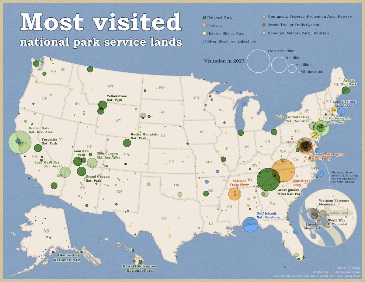
Ready to hit the road? 🚘 Celebrate the joy of summer vacation with award-winning stories about road trips and adventures in the great outdoors. Start your journey with national parks: ow.ly/6qJK50W1M5H πŸ“Έ Lauren Tierney (@tierneyl), Esri

Ready to hit the road? 🚘 

Celebrate the joy of summer vacation with award-winning stories about road trips and adventures in the great outdoors. Start your journey with national parks: ow.ly/6qJK50W1M5H

πŸ“Έ Lauren Tierney (@tierneyl), Esri
Esri (@esri) 's Twitter Profile Photo

Take your Python skills to the next level with 𝘌𝘴𝘳π˜ͺ 𝘈π˜₯𝘷𝘒𝘯𝘀𝘦π˜₯ 𝘎𝘢π˜ͺπ˜₯𝘦 𝘡𝘰 π˜—π˜Ίπ˜΅π˜©π˜°π˜― π˜ͺ𝘯 𝘈𝘳𝘀𝘎𝘐𝘚. 😎 This new guide tailored for professionals will quickly help you advance your Python skills for geospatial solutions. ow.ly/TN9450VUgnv

Take your Python skills to the next level with 𝘌𝘴𝘳π˜ͺ 𝘈π˜₯𝘷𝘒𝘯𝘀𝘦π˜₯ 𝘎𝘢π˜ͺπ˜₯𝘦 𝘡𝘰 π˜—π˜Ίπ˜΅π˜©π˜°π˜― π˜ͺ𝘯 𝘈𝘳𝘀𝘎𝘐𝘚. 😎

This new guide tailored for professionals will quickly help you advance your Python skills for geospatial solutions. ow.ly/TN9450VUgnv
Esri (@esri) 's Twitter Profile Photo

When mudslides from heavy rain blocked Oahu's Pali Highway, Dudek deployed GIS powered drones to quickly clear the vital route linking Honolulu to Kailua. ow.ly/JY0o50VV87t

When mudslides from heavy rain blocked Oahu's Pali Highway, Dudek deployed GIS powered drones to quickly clear the vital route linking Honolulu to Kailua. ow.ly/JY0o50VV87t
Esri (@esri) 's Twitter Profile Photo

The countdown is on! ⏰ Esri User Conference is a few weeks away and we can't wait to see you in San Diego. Dive into the world of maps, data, and all things GIS. πŸ”ΉRegister: ow.ly/y6NW50W4npt #EsriUC2025

Esri (@esri) 's Twitter Profile Photo

We've mapped nations and planets. But only one-fifth of the seabed 🌊 has been mapped in high-resolution. Dr. Dawn Wright (Dr. Dawn Wright + @deepseadawn.bsky.social πŸ‡ΊπŸ‡¦) explains why mapping the world's ocean is key to keeping it healthy. 🎧Listen to the podcast: ow.ly/Kg0Q50VrTfs #WorldOceanDay

We've mapped nations and planets. But only one-fifth of the seabed 🌊 has been mapped in high-resolution. Dr. Dawn Wright (<a href="/deepseadawn/">Dr. Dawn Wright + @deepseadawn.bsky.social πŸ‡ΊπŸ‡¦</a>) explains why mapping the world's ocean is key to keeping it healthy.

🎧Listen to the podcast: ow.ly/Kg0Q50VrTfs

#WorldOceanDay
Esri (@esri) 's Twitter Profile Photo

Spatial digital twins are essential for urban planning, infrastructure, & sustainability, providing real-time insights & fostering innovation.πŸ’‘ See how the Digital Twin of ZΓΌrich in Switzerland was created and how it can be used across applications. ow.ly/tH3w50W4nkT

Esri (@esri) 's Twitter Profile Photo

Grenada uses ArcGIS Image for ArcGIS Online to host imagery, make 3D basemaps, and perform AI-based feature extraction and land clover classification. 🏝️ See how Grenada’s digital twin was made: ow.ly/aH6u50W1WA0

Grenada uses ArcGIS Image for ArcGIS Online to host imagery, make 3D basemaps, and perform AI-based feature extraction and land clover classification. 

🏝️ See how Grenada’s digital twin was made: ow.ly/aH6u50W1WA0
Esri (@esri) 's Twitter Profile Photo

Prepare for takeoff! πŸͺ‚ Catch all the action from Red Bull X-Alps adventure race beginning June 15. Tune in using the 3D Live Tracking App powered by ArcGIS to watch the action live: redbullxalps.com/int-en/3d-live… #PoweredByEsri #RedBullXAlps2025

Prepare for takeoff! πŸͺ‚ 

Catch all the action from <a href="/RedBullXAlps/">Red Bull X-Alps</a> adventure race beginning June 15. Tune in using the 3D Live Tracking App powered by ArcGIS to watch the action live: redbullxalps.com/int-en/3d-live… 

#PoweredByEsri #RedBullXAlps2025
Esri (@esri) 's Twitter Profile Photo

πŸ•β€πŸ¦Ί Sniffing out mines is all in a day’s work for dogs of the APOPO (APOPO). These highly trained heroes are safely unleashed with the help of GIS to support recovery and development efforts in war-affected areas. ow.ly/JnwR50W4vSc

πŸ•β€πŸ¦Ί Sniffing out mines is all in a day’s work for dogs of the APOPO (<a href="/herorats/">APOPO</a>). These highly trained heroes are safely unleashed with the help of GIS to support recovery and development efforts in war-affected areas. ow.ly/JnwR50W4vSc
ArcGIS Enterprise (@arcgisxprise) 's Twitter Profile Photo

Get up and running with ArcGIS Online and ArcGIS Enterprise in no time! Our #GISInAMinute series offers quick, clear tutorials to help you set up your account and master the basics. Watch now and unlock the power of GIS! πŸŒŽπŸš€ Check out the playlist ➑️ ow.ly/ZjIM50Wamsh

Get up and running with <a href="/ArcGISOnline/">ArcGIS Online</a> and <a href="/ArcGISXprise/">ArcGIS Enterprise</a> in no time! Our #GISInAMinute series offers quick, clear tutorials to help you set up your account and master the basics. Watch now and unlock the power of GIS! πŸŒŽπŸš€ 

Check out the playlist ➑️ ow.ly/ZjIM50Wamsh
Esri (@esri) 's Twitter Profile Photo

Choosing the right spot for your business can make or break your success. By tapping into mapping and analytics tools, companies can foresee risks, fine-tune supply chains, and pick prime locations smartly. πŸ”ΈLearn more: forbes.com/sites/esri/202…

Choosing the right spot for your business can make or break your success. By tapping into mapping and analytics tools, companies can foresee risks, fine-tune supply chains, and pick prime locations smartly. 

πŸ”ΈLearn more: forbes.com/sites/esri/202…
Esri (@esri) 's Twitter Profile Photo

Friends don’t let friends fall behind in technology. We’ll be there for you when ArcGIS Desktop (ArcMap) retires. ow.ly/IftV50VZEpe

Friends don’t let friends fall behind in technology. We’ll be there for you when ArcGIS Desktop (ArcMap) retires. ow.ly/IftV50VZEpe