Jessica (Nolte) Leins (@wx_jess) 's Twitter Profile
Jessica (Nolte) Leins

@wx_jess

2x Sun Devil Alum. Emergency Management. Past Fed Meteorologist, Fire PIO, Public Health Prep Coord. AZ native w/ MT ties now in NC. Corgi mom.

ID: 567119269

linkhttps://www.linkedin.com/in/weatherjess calendar_today30-04-2012 10:28:23

7,7K Tweet

1,1K Followers

2,2K Following
National Hurricane Center (@nhc_atlantic) 's Twitter Profile Photo

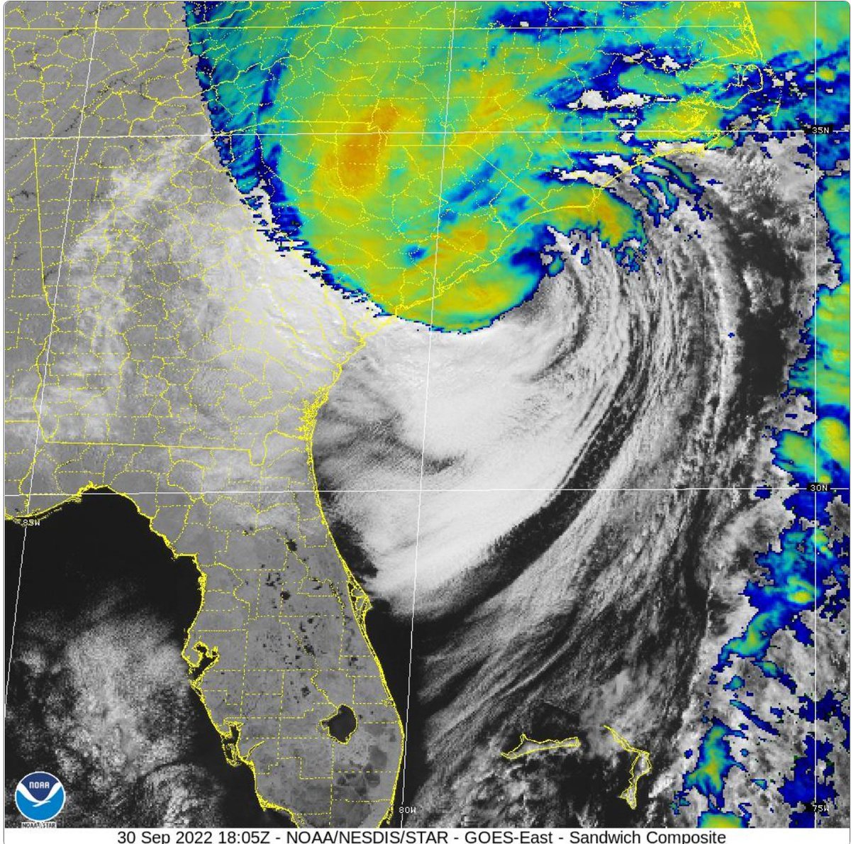
Update: Surface observations indicate that the center of #Hurricane #Ian made landfall on Sep 30 at 205 pm EDT (1805 UTC) near Georgetown, South Carolina with maximum sustained winds of 85 mph (140 km/h) and an estimated minimum central pressure of 977 mb (28.85 inches).

Update: Surface observations indicate that the center of #Hurricane #Ian made landfall on Sep 30 at 205 pm EDT (1805 UTC) near Georgetown, South Carolina with maximum sustained winds of 85 mph (140 km/h) and an 
estimated minimum central pressure of 977 mb (28.85 inches).
Jessica (Nolte) Leins (@wx_jess) 's Twitter Profile Photo

Love seeing more “messaging” capabilities with mPing. The Groundhog Day ones were fun, but this one of early dismissal for schools is significant. Stay safe out there all under the various risk levels for severe Wx this afternoon and evening. #mPing #iawx

Love seeing more “messaging” capabilities with mPing. The Groundhog Day ones were fun, but this one of early dismissal for schools is significant. Stay safe out there all under the various risk levels for severe Wx this afternoon and evening. #mPing #iawx
Raleigh Fire Department (@raleighncfire) 's Twitter Profile Photo

These kids were very lucky today! We know creeks & rivers will be high today, which makes them very dangerous. Please stay safe, Raleigh!

NWS Weather Prediction Center (@nwswpc) 's Twitter Profile Photo

A rare High Risk of excessive rainfall is in place for the southern Appalachians Thursday-Thursday night where considerable flash/urban/river flooding and landslides are possible.

A rare High Risk of excessive rainfall is in place for the southern Appalachians Thursday-Thursday night where considerable flash/urban/river flooding and landslides are possible.
Jessica (Nolte) Leins (@wx_jess) 's Twitter Profile Photo

Watching this rotating storm from the office on the radar and then the parking lot was interesting. Gonna be a long night and day tomorrow for so many across the SE. #ncwx #Helene #raleigh #turnarounddontdrown

Jessica (Nolte) Leins (@wx_jess) 's Twitter Profile Photo

TRDU (Terminal Doppler) getting a good look at that circulation/tornado warned cell moving through northern Wake County. #ncwx #Helene

National Hurricane Center (@nhc_atlantic) 's Twitter Profile Photo

Update 7:00 PM EDT Thurs: Extremely dangerous Category 4 Helene heading towards the Florida Big Bend Sustained tropical-storm-force winds are being reported along the west coast of Florida, with wind gusts near hurricane-force. Tropical storm conditions are approaching the

Update 7:00 PM EDT Thurs: Extremely dangerous Category 4 Helene heading towards the Florida Big Bend

Sustained tropical-storm-force winds are being reported along the west coast of Florida, with wind gusts near hurricane-force.  Tropical storm conditions are approaching the
Raleigh Water (@raleigh_water) 's Twitter Profile Photo

Raleigh Water crews are on the road to Asheville to lend a helping hand! 💦💪 Our team is bringing 50 tons of pipes and essential supplies to help restore the city's water infrastructure after Hurricane Helene. Together, we'll rebuild stronger. #HurricaneRelief #Asheville

NCDOT (@ncdot) 's Twitter Profile Photo

Even into the daytime hours, road dangers still exist in parts of central NC. 🚫 DO NOT go around barriers or attempt to pass flooded roads. Check DriveNC.gov for real-time conditions. (🎥 Old Oxford Hwy Bridge near Snow Hill Rd. in Durham Co.)

RaleighCommunity (@raleighcomm) 's Twitter Profile Photo

Come out to Mt. Moriah Community Church at 1500 Garner Rd now until 1:00pm and get a free NOAA Weather Radio, and receive some tips to stay safe during this hurricane season.