Carolina Ready (@unc_ready) 's Twitter Profile
Carolina Ready

@unc_ready

Be ready, Carolina! Tweets about what to do before, during and after an emergency. Keeping Carolina ready and safe!

ID: 1161583169314918400

linkhttps://carolinaready.unc.edu calendar_today14-08-2019 10:19:43

306 Tweet

409 Followers

112 Following

Carolina Ready (@unc_ready) 's Twitter Profile Photo

Forecasts give key info before a storm—like track, wind speed & rainfall. Don’t wait to tune in. Knowing how to read the forecast helps you make safer decisions early. 🌪️⛈️ ➡️ Stay informed go.unc.edu/hpwmay6.

Forecasts give key info before a storm—like track, wind speed & rainfall. Don’t wait to tune in. Knowing how to read the forecast helps you make safer decisions early. 🌪️⛈️

➡️ Stay informed go.unc.edu/hpwmay6.
Carolina Ready (@unc_ready) 's Twitter Profile Photo

When a storm threatens, don’t wait—get moving! 🏃 Prep early with supplies and a plan before hurricane season. When a storm is on the way, time moves fast and stores empty faster. ➡️ Learn more and stay ready go.unc.edu/hpwmay7.

Carolina Ready (@unc_ready) 's Twitter Profile Photo

Stay safe during storms. Whether you evacuate or shelter in place, know the risks, stay alert, and keep up with forecasts and official updates. Learn more ways to stay protected during storms go.unc.edu/hpwmay8.

Stay safe during storms. Whether you evacuate or shelter in place, know the risks, stay alert, and keep up with forecasts and official updates. 

Learn more ways to stay protected during storms go.unc.edu/hpwmay8.
Carolina Ready (@unc_ready) 's Twitter Profile Photo

Even after the skies clear, danger isn’t over. Nearly HALF of hurricane fatalities happen after the storm. Stay alert, avoid floodwaters, and follow official guidance. 🌊 🔗 Learn more about using caution after storms go.unc.edu/hpwmay9.

Even after the skies clear, danger isn’t over. Nearly HALF of hurricane fatalities happen after the storm. Stay alert, avoid floodwaters, and follow official guidance. 🌊

🔗 Learn more about using caution after storms go.unc.edu/hpwmay9.
Carolina Ready (@unc_ready) 's Twitter Profile Photo

Are you ready for hurricane season? 🌪️ Start prepping now—know your risk, understand forecasts, and plan what to do before, during & after a storm. Even if you're prepared, there’s always more to learn. go.unc.edu/hpwmay10

Are you ready for hurricane season? 🌪️ Start prepping now—know your risk, understand forecasts, and plan what to do before, during & after a storm. Even if you're prepared, there’s always more to learn. go.unc.edu/hpwmay10
Carolina Ready (@unc_ready) 's Twitter Profile Photo

NOAA forecasts an above-normal 2025 Atlantic hurricane season (June 1–Nov 30): 🌀60% chance above-normal 🌀13–19 named storms 🌀6–10 hurricanes 🌀 3–5 major hurricanes Be Informed, Be Prepared, & ready to Take Action this hurricane season! Learn more - noaa.gov/news-release/n…

UNC Environment, Health and Safety (@unc_ehs) 's Twitter Profile Photo

Stay safe in the heat! ☀️ Hydrate, stay cool, dress light, and limit outdoor activity. Check on others & know heat illness signs. Learn more by visiting go.unc.edu/BeatTheHeat.

Stay safe in the heat! ☀️ Hydrate, stay cool, dress light, and limit outdoor activity. Check on others & know heat illness signs. Learn more by visiting go.unc.edu/BeatTheHeat.
NWS Raleigh (@nwsraleigh) 's Twitter Profile Photo

⛈️After the storms tomorrow, the heat will take over during the weekend and especially early next week! 🥵Be prepared now for extremely warm temperatures. 🔥When heat index values are expected to be between 105°-109° we will issue a Heat Advisory for the area. #NCwx #NCheat

⛈️After the storms tomorrow, the heat will take over during the weekend and especially early next week! 
🥵Be prepared now for extremely warm temperatures. 
🔥When heat index values are expected to be between 105°-109° we will issue a Heat Advisory for the area. 
#NCwx #NCheat
Carolina Ready (@unc_ready) 's Twitter Profile Photo

Major heat wave rolling in June 23-26. This isn't just summer warmth, it will be extremely dangerous! Think ☀️"surface of the sun"☀️ vibes! ☑️Ditch outdoor activities ☑️Embrace indoor Netflix binges ☑️Stay hydrated ☑️Be 🚨#CarolinaReady More heat info: ready.gov/heat

Major heat wave rolling in June 23-26. This isn't just summer warmth, it will be extremely dangerous! Think ☀️"surface of the sun"☀️ vibes! 

☑️Ditch outdoor activities
☑️Embrace indoor Netflix binges
☑️Stay hydrated 
☑️Be 🚨#CarolinaReady

More heat info: ready.gov/heat
NWS Raleigh (@nwsraleigh) 's Twitter Profile Photo

NWS Raleigh has issued a Heat Advisory for today for all of central NC. The heat index will exceed 100°F for most of the area each day this week. Heat can be deadly. Visit weather.gov/safety/heat or heat.gov/pages/planning… for tips on how to stay safe. #ncwx

NWS Raleigh has issued a Heat Advisory for today for all of central NC. The heat index will exceed 100°F for most of the area each day this week. Heat can be deadly. Visit weather.gov/safety/heat or heat.gov/pages/planning… for tips on how to stay safe. #ncwx
NWS Raleigh (@nwsraleigh) 's Twitter Profile Photo

Dangerous heat continues today. NWS Raleigh has issued an Extreme Heat Warning for much of central NC, with a Heat Advisory for western areas, both in effect thru Wed. The heat index will exceed 100°F thru much of this week. Visit heat.gov for safety tips. #ncwx

Dangerous heat continues today. NWS Raleigh has issued an Extreme Heat Warning for much of central NC, with a Heat Advisory for western areas, both in effect thru Wed. The heat index will exceed 100°F thru much of this week. Visit heat.gov for safety tips. #ncwx
UNC Environment, Health and Safety (@unc_ehs) 's Twitter Profile Photo

📣 We've launched a no-cost, hands-on CPR/AED Awareness Training for all @unc employees to boost emergency preparedness. To learn more or schedule a training, contact Ashley Hester at [email protected]. ow.ly/aFaH50WlNV7
NWS Raleigh (@nwsraleigh) 's Twitter Profile Photo

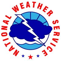
🚨 A Flood Watch will be in effect from 2 PM today until 2 AM tonight! ⛈️ Scattered to numerous showers/storms will be capable of torrential downpours and strong to severe wind gusts. 💧 Localized amounts of 2 to 5+ inches will be possible anywhere across the Piedmont. #NCwx

🚨 A Flood Watch will be in effect from 2 PM today until 2 AM tonight!

⛈️ Scattered to numerous showers/storms will be capable of torrential downpours and strong to severe wind gusts.

💧 Localized amounts of 2 to 5+ inches will be possible anywhere across the Piedmont. #NCwx
Carolina Ready (@unc_ready) 's Twitter Profile Photo

Severe rain expected this evening with potential flash floods. Remember: "Turn Around, Don't Drown!" Even a few inches of fast-moving water can sweep you off your feet or float a car. Stay indoors if possible, especially after dark. More flash flood info: emp.unc.edu/news/2025/03/0…

Severe rain expected this evening with potential flash floods. Remember: "Turn Around, Don't Drown!" Even a few inches of fast-moving water can sweep you off your feet or float a car. Stay indoors if possible, especially after dark.

More flash flood info: emp.unc.edu/news/2025/03/0…
UNC Campus Safety (@unccampussafety) 's Twitter Profile Photo

A thunderstorm bringing heavy rains will move through our region, increasing the risk of downed trees, power lines, and flooding due to impacts from Tropical Storm Chantal. UNC EMP Director Darrell Jeter shares a message on what you can do to keep safe go.unc.edu/CarolinaStorms.

A thunderstorm bringing heavy rains will move through our region, increasing the risk of downed trees, power lines, and flooding due to impacts from Tropical Storm Chantal. UNC EMP Director Darrell Jeter shares a message on what you can do to keep safe go.unc.edu/CarolinaStorms.
NWS Raleigh (@nwsraleigh) 's Twitter Profile Photo

A Flood Watch is in effect for all of central NC through 2 AM tonight as numerous showers/storms are expected to develop today. Places that saw excessive rain yesterday and from Chantal are at the highest risk. Isolated damaging wind gusts are also possible with any storms. #ncwx

A Flood Watch is in effect for all of central NC through 2 AM tonight as numerous showers/storms are expected to develop today. Places that saw excessive rain yesterday and from Chantal are at the highest risk. Isolated damaging wind gusts are also possible with any storms. #ncwx
NWS Raleigh (@nwsraleigh) 's Twitter Profile Photo

Another hot and humid day expected today. A Heat Advisory will be in effect from 11 AM until 8 PM. Scattered storms will be capable to strong wind gusts, lightning and torrential rainfall. #NCwx

Another hot and humid day expected today. A Heat Advisory will be in effect from 11 AM until 8 PM. Scattered storms will be capable to strong wind gusts, lightning and torrential rainfall. #NCwx
Carolina Ready (@unc_ready) 's Twitter Profile Photo

Dangerous high heat coming this weekend! Be 🚨#carolinaready by staying hydrated and hanging out in cool places. For more info about heat safety, visit ready.gov/heat

NWS Raleigh (@nwsraleigh) 's Twitter Profile Photo

Potentially dangerous heat returns today. A Heat Advisory is in effect today from 11 am to 8 pm today due to hot and humid conditions. This will mark the beginning of a prolonged period of oppressive heat that will last well into next week. #NCwx

Potentially dangerous heat returns today. A Heat Advisory is in effect today from 11 am to 8 pm today due to hot and humid conditions. This will mark the beginning of a prolonged period of oppressive heat that will last well into next week. #NCwx
NWS Raleigh (@nwsraleigh) 's Twitter Profile Photo

A long-duration heat wave will last through the upcoming weekend, with heat indices between 105 and 112 degrees. Heat is the leading weather-related killer in the U.S. Limit outdoor activity, stay hydrated, and ensure access to air-conditioning and other cooling areas. #NCwx

A long-duration heat wave will last through the upcoming weekend, with heat indices between 105 and 112 degrees. Heat is the leading weather-related killer in the U.S. Limit outdoor activity, stay hydrated, and ensure access to air-conditioning and other cooling areas. #NCwx