Tobias Lunt (@tobylunt) 's Twitter Profile
Tobias Lunt

@tobylunt

Co-founder @devdatalab. Tinkerer, learner, cook, life enthusiast. Data for a purpose.

ID: 1517114022

calendar_today14-06-2013 17:48:56

233 Tweet

444 Followers

97 Following

Sam Asher (@thesamasher) 's Twitter Profile Photo

🚨📊🚌Migration data now available on our COVID-19 India open data hub (github.com/devdatalab/cov…), contributed by/thanks to Clément Imbert John Firth. Blue map shows migrant destinations currently sending people home, green map shows migrant origins they’re returning to. (1/2)

🚨📊🚌Migration data now available on our COVID-19 India open data hub (github.com/devdatalab/cov…), contributed by/thanks to <a href="/clem_imbert/">Clément Imbert</a> <a href="/John_S_Firth/">John Firth</a>. Blue map shows migrant destinations currently sending people home, green map shows migrant origins they’re returning to. (1/2)
Sam Asher (@thesamasher) 's Twitter Profile Photo

Are night lights (NL) a reliable proxy for local GDP? An answer, in our paper “Development Research at High Geographic Resolution” aka the SHRUG paper (forthcoming at WBER). 🧵1/14 TL;DR: don’t trust existing GDP elasticities. With Paul Novosad @tobiaslunt @ryu_matsuura
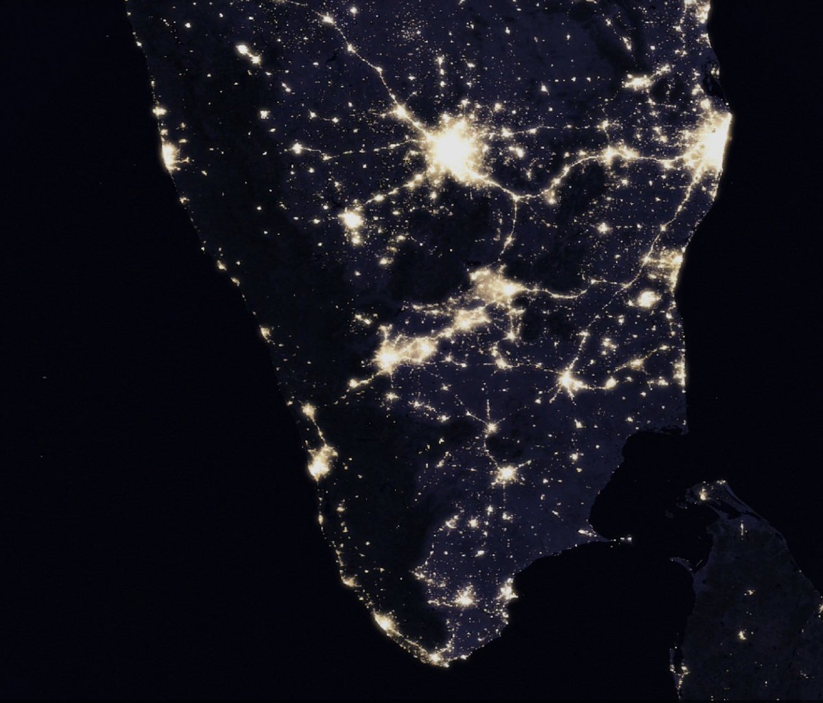
Are night lights (NL) a reliable proxy for local GDP?

An answer, in our paper “Development Research at High Geographic Resolution” aka the SHRUG paper (forthcoming at WBER). 🧵1/14

TL;DR: don’t trust existing GDP elasticities. With <a href="/paulnovosad/">Paul Novosad</a> @tobiaslunt @ryu_matsuura
Samuel Sinyangwe (@samswey) 's Twitter Profile Photo

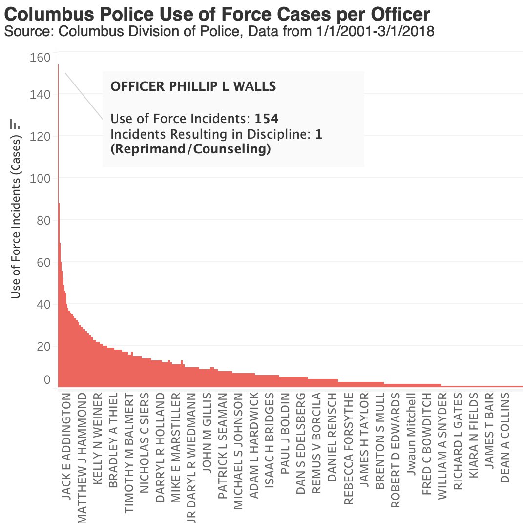
Here’s how often each Columbus police officer used force against people from 2001-2018. Some used force at substantially higher rates. But how often were they held accountable? A thread. (1/x)

Here’s how often each Columbus police officer used force against people from 2001-2018. Some used force at substantially higher rates. But how often were they held accountable? A thread. (1/x)
Paul Novosad (@paulnovosad) 's Twitter Profile Photo

We (ie. Tobias Lunt) made a district-level COVID forecast for India: devdatalab.org/covid-forecast A lot of places are past the peak of the second wave. In a lot of places, case counts are still rising. We show Rt calculated from a model based on Bettencourt and Soman (2020). 🧵1/3

We (ie. <a href="/tobylunt/">Tobias Lunt</a>) made a district-level COVID forecast for India: devdatalab.org/covid-forecast

A lot of places are past the peak of the second wave. In a lot of places, case counts are still rising.

We show Rt calculated from a model based on Bettencourt and Soman (2020). 🧵1/3
Anup Malani (@anup_malani) 's Twitter Profile Photo

New Substack posts on India's progress with vaccination. These posts are joint with Stuti Sachdeva & Manoj Mohanan. It relies on vaccination data from Development Data Lab (Thanks Sam Asher Paul Novosad Toby) anupmalani.substack.com/p/vaccination-…

IFPRI (@ifpri) 's Twitter Profile Photo

♨️️ IFPRI's 2022 Global Food Policy Report is out NOW! 📌 "#ClimateChange and #FoodSystems" 📚 12 chapters of the latest food policy insights Check out the #GFPR2022 website 👉 bit.ly/GFPR2022 CGIAR #OneCGIAR #OpenAccess

♨️️ <a href="/IFPRI/">IFPRI</a>'s 2022 Global Food Policy Report is out NOW! 

📌 "#ClimateChange and #FoodSystems"  

📚 12 chapters of the latest food policy insights 

Check out the #GFPR2022 website 👉 bit.ly/GFPR2022 

<a href="/CGIAR/">CGIAR</a> #OneCGIAR #OpenAccess
Stephen Kennedy (@oh_sk) 's Twitter Profile Photo

Making maps of 📍Madison for the #30DayMapChallenge! For Day 1 “points,” I pulled the street tree dataset from City of Madison, Wisconsin (HT Mary Pustejovsky (@[email protected])!) and categorized each species by fall foliage color 🍁. Mapped using UrbanFootprint #gis #mapdesign #cartography #madewithUF

Making maps of 📍Madison for the #30DayMapChallenge!

For Day 1 “points,” I pulled the street tree dataset from <a href="/CityofMadison/">City of Madison, Wisconsin</a> (HT <a href="/mpusto/">Mary Pustejovsky (@mpusto@urbanists.social)</a>!) and categorized each species by fall foliage color 🍁. 

Mapped using <a href="/UFPlatform/">UrbanFootprint</a> #gis #mapdesign #cartography #madewithUF
Bill McKibben (@billmckibben) 's Twitter Profile Photo

Drought and war are leading to a 4-nation African famine, the "biggest humanitarian disaster since World War II" nytimes.com/2017/03/27/wor…

Tobias Lunt (@tobylunt) 's Twitter Profile Photo

“Dear Senator Johnson: To support our state, you must support environmental policy” by @osanderfoot medium.com/@osanderfoot/d…

Tobias Lunt (@tobylunt) 's Twitter Profile Photo

Whoa. Important read. Aid in reverse: how poor countries develop rich countries | Jason Hickel theguardian.com/global-develop…