Anish Ratna Shakya (@shakyaanice) 's Twitter Profile
Anish Ratna Shakya

@shakyaanice

Research Associate | RS & GIS | Disaster Risk Reduction | Hazard modeler | Multi-hazard Risk | Nature Based Solutions | Cartography |

ID: 2160598868

calendar_today28-10-2013 10:02:46

50 Tweet

99 Followers

260 Following

Kenneth Field (@kennethfield) 's Twitter Profile Photo

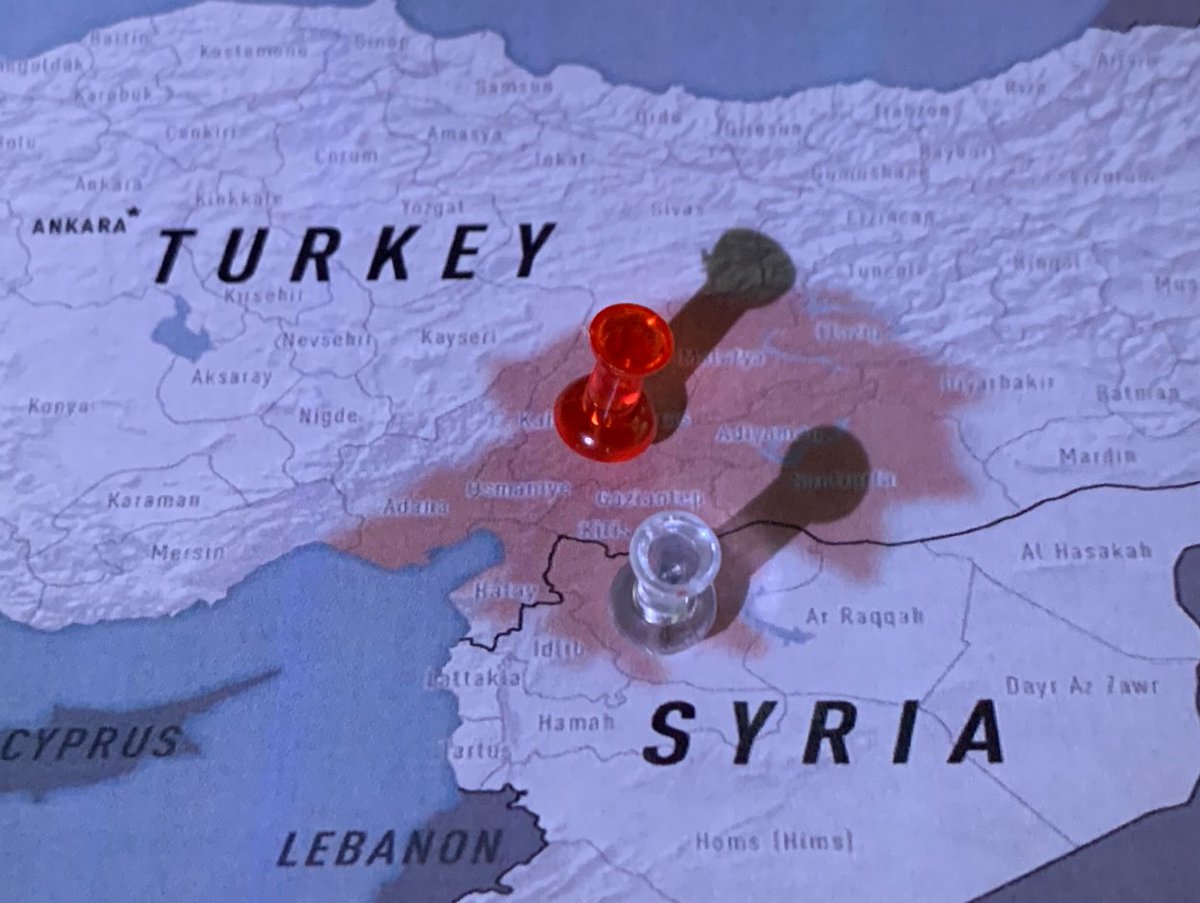
Maps of the Turkey/Syria earthquake - a cartoblography review by me discussing the design of maps of the disaster. Mostly great examples, but also calling out some less than useful for those who still appreciate them. cartoblography.com/2023/02/15/map… #maps #earthquakes #cartography

Maps of the Turkey/Syria earthquake - a cartoblography review by me discussing the design of maps of the disaster.

Mostly great examples, but also calling out some less than useful for those who still appreciate them.

cartoblography.com/2023/02/15/map…

#maps #earthquakes #cartography
Anish Ratna Shakya (@shakyaanice) 's Twitter Profile Photo

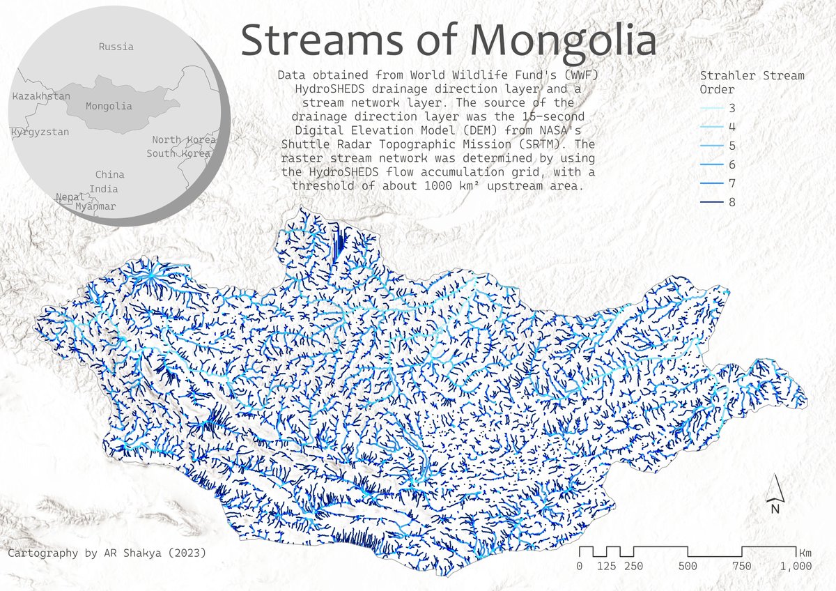
Week 9 theme: NGO Data I used WWF's HydroSHEDs data for preparing the stream order network of Mongolia. #MapPromptMonday #gischat

Week 9 theme: NGO Data
I used WWF's HydroSHEDs data for preparing the stream order network of Mongolia.

#MapPromptMonday #gischat
Anish Ratna Shakya (@shakyaanice) 's Twitter Profile Photo

Week 10 theme: Favorite Animal For this week, I have mapped the habitats of existing five species of rhinoceros in the world using a dataset from IUCN Red List for Threatened Species. #MapPromptMonday #gischat

Week 10 theme: Favorite Animal
For this week, I have mapped the habitats of existing five species of rhinoceros in the world using a dataset from IUCN Red List for Threatened Species.

#MapPromptMonday #gischat
Anish Ratna Shakya (@shakyaanice) 's Twitter Profile Photo

Week 11 theme: Earth Imagery The changes in the natural and built environments can be monitored as a time-lapse using the vast collection of Earth imageries. Image collection: Landsat (2000-2020) Location: Koshi River, Nepal #MapPromptMonday #giswqs #gischat

Anish Ratna Shakya (@shakyaanice) 's Twitter Profile Photo

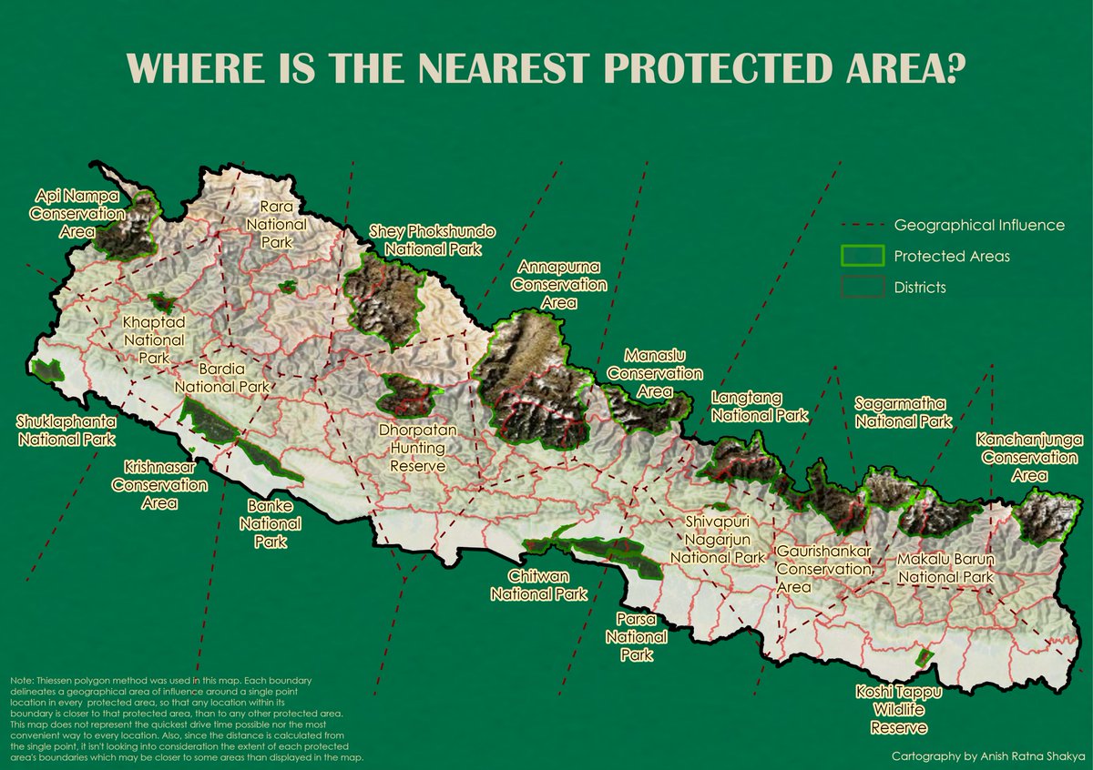
Week 12 theme: Inspired by.. A bit late !! Find your nearest protected area in Nepal. Inspired by Emily Meriam 's blog. #MapPromptMonday #arcpro #thiessenpolygon #conservationarea

Week 12 theme: Inspired by..
A bit late !! Find your nearest protected area in Nepal. Inspired by Emily Meriam 's blog.
#MapPromptMonday #arcpro #thiessenpolygon #conservationarea
Anish Ratna Shakya (@shakyaanice) 's Twitter Profile Photo

Week 13 theme: Recent Disaster Near Real-Time fire detection using NASA's FIRMS platform #MapPromptMonday #arcgispro #fire #heatmap

Week 13 theme: Recent Disaster
Near Real-Time fire detection using NASA's FIRMS platform 
#MapPromptMonday #arcgispro #fire #heatmap
Tenzing C. Sherpa (@ten10zing92) 's Twitter Profile Photo

Imagine standing at the summit of Mount Everest 📷 📷, feeling the freezing thin air against your skin. Have you ever wondered how long you could withstand those extreme conditions before experiencing frostbite?

Imagine standing at the summit of Mount Everest 📷 📷, feeling the freezing thin air against your skin. Have you ever wondered how long you could withstand those extreme conditions before experiencing frostbite?
Anish Ratna Shakya (@shakyaanice) 's Twitter Profile Photo

These ‘warming stripe’ graphics are visual representations of the change in temperature as measured in each country over the past 100+ years. Check your country’s stripes in showyourstripes.info/faq #global_warming #Nepal

These ‘warming stripe’ graphics are visual representations of the change in temperature as measured in each country over the past 100+ years.
Check your country’s stripes in showyourstripes.info/faq
#global_warming #Nepal
David Montero Loaiza (@dmlmont) 's Twitter Profile Photo

I'm happy to announce that our #AwesomeSpectralIndices paper is out! 🥳🛰️🌿 Scientific Data 🔗 nature.com/articles/s4159… 🧵 1/8 #EOchat #GISchat #RemoteSensing #DataViz

Chathumal Weththasinghe (@chathumal93) 's Twitter Profile Photo

A simple approach to segmenting flood areas based on U-Net architecture github.com/chathumal93/Py… #UNet #PyTorch #FloodMapping

Anish Ratna Shakya (@shakyaanice) 's Twitter Profile Photo

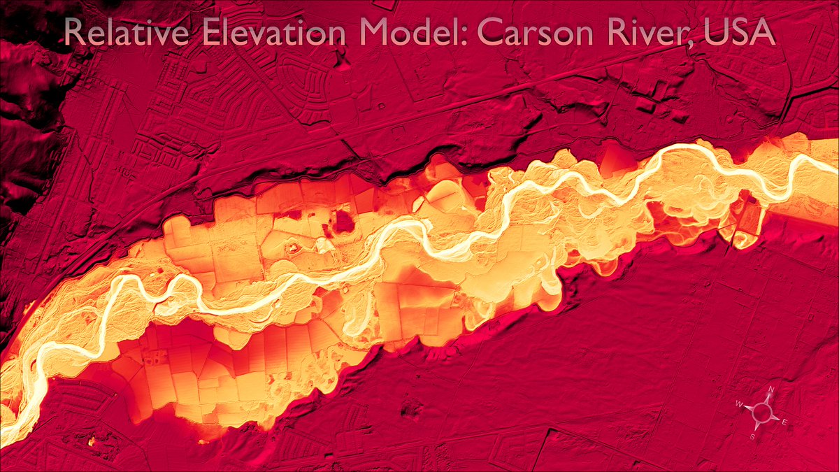
Week 15 theme: Topography Relative Elevation Model of Carson River, USA Made a year ago with help of Daniel Coe's tutorial. #MapPromptMonday #lidar #arcpro

Week 15 theme: Topography 
Relative Elevation Model of Carson River, USA
Made a year ago with help of Daniel Coe's tutorial. 
#MapPromptMonday
#lidar #arcpro
Anish Ratna Shakya (@shakyaanice) 's Twitter Profile Photo

Happy Earth Day 🌏 Week 16 theme: Environment Forest Landscape Integrity Index of Vietnam #MapPromptMonday #gischat #EarthDay2023

Happy Earth Day 🌏
Week 16 theme: Environment
Forest Landscape Integrity Index of Vietnam
#MapPromptMonday #gischat #EarthDay2023
Roxy Koll ⛈ (@rocksea) 's Twitter Profile Photo

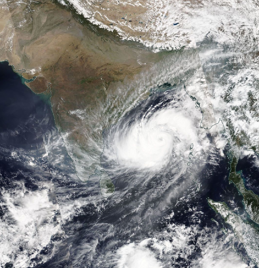
1/ Rapid intensification of Cyclones. #CycloneMocha underwent continious rapid intensification, and is an extremely severe cyclone at about 220 km/hr maximum wind speed. 11–12 May: intensified from 65 km/hr to 120 km/hr. 12–13 May: intensified from 120 km/hr to 213 km/hr.

1/ Rapid intensification of Cyclones.

#CycloneMocha underwent continious rapid intensification, and is an extremely severe cyclone at about 220 km/hr maximum wind speed.

11–12 May: intensified from 65 km/hr to 120 km/hr.
12–13 May: intensified from 120 km/hr to 213 km/hr.
Geoinformatics Center (@gicait) 's Twitter Profile Photo

Curious how #flood can be learned in the risk assessment for #disastermanagement? Recently, GIC conducted a training for the experts in Hydrology and Meteorology from Bhutan in deploying the spatial modelling and information. See our full story here geoinfo.ait.ac.th/flood-risk-ass…

Curious how #flood can be learned in the risk assessment for #disastermanagement? Recently, GIC conducted a training for the experts in Hydrology and Meteorology from Bhutan in deploying the spatial modelling and information.

See our full story here geoinfo.ait.ac.th/flood-risk-ass…
hillson ghimire (@hillsonghimire) 's Twitter Profile Photo

Herat Earthquake, Afghanistan: Examining the impact using #InSAR technique using the ground motion along the satellite's line-of-sight (LOS). The map product is derived using #sentinel1 on ascending pass captured on Sept 25 and Oct 07, 2023. #ESA #Earthquake #EOChat Copernicus EU
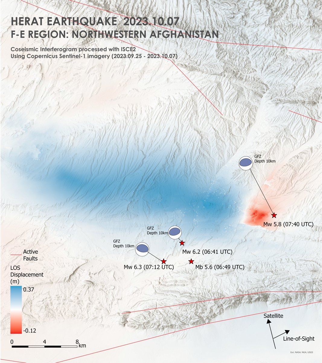
Herat Earthquake, Afghanistan: Examining the impact using #InSAR technique using the ground motion along the satellite's line-of-sight (LOS). The map product is derived using #sentinel1 on ascending pass captured on Sept 25 and Oct 07, 2023.
#ESA #Earthquake #EOChat <a href="/CopernicusEU/">Copernicus EU</a>