James Wes Lee (@osujwl) 's Twitter Profile
James Wes Lee

@osujwl

ID: 977183935863107584

calendar_today23-03-2018 14:03:00

626 Tweet

100 Followers

57 Following

Oklahoma Mesonet (@okmesonet) 's Twitter Profile Photo

This is probably the last 70+ temp we will see in the state this week and maybe for a while. Long range forecasts indicate cooler than normal temperatures for the next two weeks. #okmesonet

This is probably the last 70+ temp we will see in the state this week and maybe for a while. Long range forecasts indicate cooler than normal temperatures for the next two weeks. #okmesonet
Oklahoma Mesonet (@okmesonet) 's Twitter Profile Photo

Much drier air mass compared to yesterday. This will allow for much cooler nighttime temperatures until pattern changes. #okmesonet

Much drier air mass compared to yesterday. This will allow for much cooler nighttime temperatures until pattern changes. #okmesonet
Oklahoma Mesonet (@okmesonet) 's Twitter Profile Photo

It has been a while since we have seen winds like today. Expect windy conditions to continue through the weekend but at wind speeds below what we are encountering today. #okmesonet

It has been a while since we have seen winds like today.   Expect windy conditions to continue through the weekend but at wind speeds below what we are encountering today.  #okmesonet
Oklahoma Mesonet (@okmesonet) 's Twitter Profile Photo

Recent Oklahoma lake levels. A few lakes showing low levels but none more important than lake Altus-Lugert. After 2 growing seasons with limited to no irrigation water leaving the lake producers desperately need runoff in the watershed before the 2024 growing season. #okmesonet

Recent Oklahoma lake levels. A few lakes showing low levels but none more important than lake Altus-Lugert. After 2  growing seasons with limited to no irrigation water leaving the lake producers desperately need runoff in the watershed before the 2024 growing season. #okmesonet
Oklahoma Mesonet (@okmesonet) 's Twitter Profile Photo

There were some very cold numbers on this morning's Cattle Comfort Index (CCI), reaching down into the negative "Cold Danger" category in the panhandle. Expect even more severe conditions next week when CCI numbers could be negative statewide. #okmesonet

There were some very cold numbers on this morning's Cattle Comfort Index (CCI), reaching down into the negative "Cold Danger" category in the panhandle. Expect even more severe conditions next week when CCI numbers could be negative statewide. #okmesonet
Oklahoma Mesonet (@okmesonet) 's Twitter Profile Photo

Soil temperatures have certainly dropped this week but are still slightly above freezing under vegetation at most locations. The site at Alva is showing below freezing under bare soil at 10 cm (4 inches). But under insulating sod all depths are above 32 degrees. #okmesonet

Soil temperatures have certainly dropped this week but are still slightly above freezing under vegetation at most locations. The site at Alva is showing below freezing under bare soil at 10 cm (4 inches). But under insulating sod all depths are above 32 degrees. #okmesonet
Oklahoma Mesonet (@okmesonet) 's Twitter Profile Photo

With the recent cold weather the current soil temperatures near the surface are either freezing or very close to it. Icing will be highly likely as we go into the evening and overnight hours. #okmesonet

With the recent cold weather the current soil temperatures near the surface are either freezing or very close to it. Icing will be highly likely as we go into the evening and overnight hours. #okmesonet
Oklahoma Mesonet (@okmesonet) 's Twitter Profile Photo

When will we see the sun again? It's been a few days with extreme overcast conditions. If we are going to see above average temperatures tomorrow, the dense cover will have to go. #okmesonet

When will we see the sun again? It's been a few days with extreme overcast conditions. If we are going to see above average temperatures tomorrow, the dense cover will have to go. #okmesonet
Oklahoma Mesonet (@okmesonet) 's Twitter Profile Photo

Yesterday broke a 10-day streak of below normal high temperatures. Today expect the warmth to continue with highs exceeding the statewide normal high of about 53° by 10 to 15°. #okmesonet

Yesterday broke a 10-day streak of below normal high temperatures. Today expect the warmth to continue with highs exceeding the statewide normal high of about 53° by 10 to 15°. #okmesonet
Oklahoma Mesonet (@okmesonet) 's Twitter Profile Photo

A reminder that Mesonet has several different soil temperature maps. This 4-inch, 3-day average map under bare soil is a good reference to use for when to plant seeds and to give you an idea when grassy weeds such as crabgrass start germinating (>55°F). #okmesonet

A reminder that Mesonet has several different soil temperature maps. This 4-inch, 3-day average map under bare soil is a good reference to use for when to plant seeds and to give you an idea when grassy weeds such as crabgrass start germinating (>55°F). #okmesonet
Oklahoma Mesonet (@okmesonet) 's Twitter Profile Photo

While most of the state has good soil moisture conditions the northwest seems to have missed out somewhat on recent rainfall. 1 to 2 months without a 1/4 inch of rain in parts of Woods and Beaver counties. #okmesonet

While most of the state has good soil moisture conditions the northwest seems to have missed out somewhat on recent rainfall.  1 to 2 months without a 1/4 inch of rain in parts of Woods and Beaver counties. #okmesonet
Oklahoma Mesonet (@okmesonet) 's Twitter Profile Photo

Nice to see a little measurable rainfall on the map. Unfortunately, either nothing or not enough to impact potential wildfire weather this weekend in the panhandle and northwest. #okmesonet

Nice to see a little measurable rainfall on the map. Unfortunately, either nothing or not enough to impact potential wildfire weather this weekend in the panhandle and northwest. #okmesonet
OSU Small Grains (@osu_smallgrains) 's Twitter Profile Photo

All varieties have reached FHS. Varieties reported here with the earliest FHS date should be the first to monitor in commercial fields. First Hollow Stem Update – 3/6/2024 osuwheat.com/2024/03/06/fir…

All varieties have reached FHS. Varieties reported here with the earliest FHS date should be the first to monitor in commercial fields. 

First Hollow Stem Update – 3/6/2024 osuwheat.com/2024/03/06/fir…
Oklahoma Mesonet (@okmesonet) 's Twitter Profile Photo

Best chance of rain tonight that we have seen in a while. Thunderstorm chances start in the west this afternoon and continue into southeastern Oklahoma on Friday morning. #okmesonet

Best chance of rain tonight that we have seen in a while. Thunderstorm chances start in the west this afternoon and continue into southeastern Oklahoma on Friday morning. #okmesonet
Oklahoma Mesonet (@okmesonet) 's Twitter Profile Photo

Another day of high winds and low humidity in the northwest. Until green up or adequate rains occur, be extra careful with wildfire potential. Oklahoma Mesonet
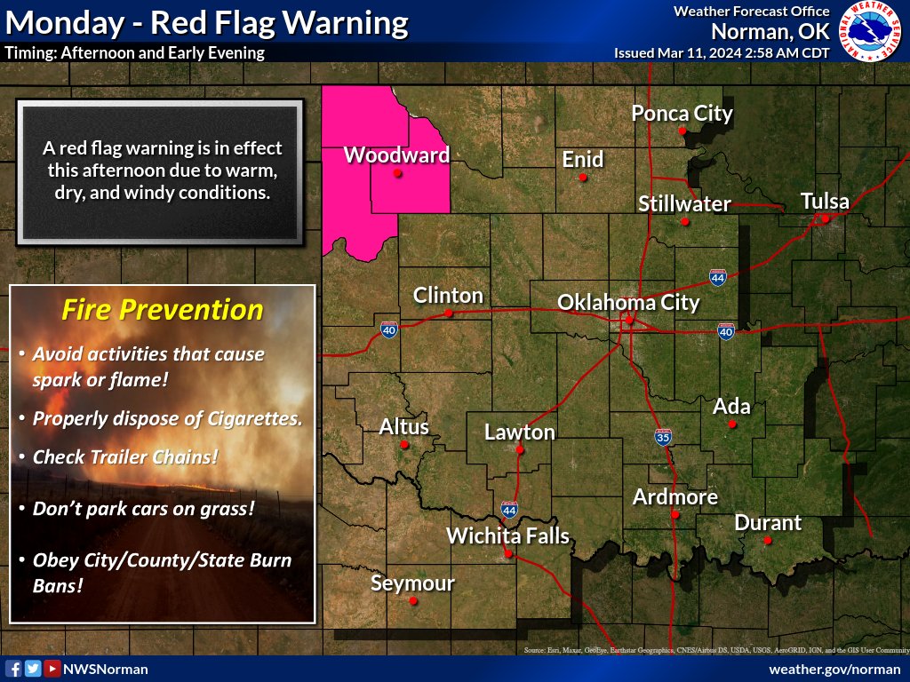
Another day of high winds and low humidity in the northwest. Until green up or adequate rains occur, be extra careful with wildfire potential. <a href="/okmesonet/">Oklahoma Mesonet</a>
Oklahoma Mesonet (@okmesonet) 's Twitter Profile Photo

Dangerous conditions in northwest Oklahoma today. Several more hours of high winds and low humidities before we can lower the wildfire potential. #okmesonet

Dangerous conditions in northwest Oklahoma today.  Several more hours of high winds and low humidities before we can lower the wildfire potential. #okmesonet
Oklahoma Mesonet (@okmesonet) 's Twitter Profile Photo

This cycle of the El Nino is just about gone. All projections lean towards La Nina for fall. Remember this system has little impact on weather conditions in the summer months. #okmesonet

This cycle of the El Nino is just about gone.  All projections lean towards La Nina for fall.  Remember this system has little impact on weather conditions in the summer months. #okmesonet