NASA SMAP (@nasasmap) 's Twitter Profile
NASA SMAP

@nasasmap

Soil Moisture Active and Passive (SMAP) mission launched on January 31, 2015. This account is no longer active.

ID: 198597135

linkhttp://smap.jpl.nasa.gov calendar_today04-10-2010 19:03:23

524 Tweet

9,9K Followers

25 Following

NASA SMAP (@nasasmap) 's Twitter Profile Photo

Data from SMAP are now being used operationally by the U.S. Department of Agriculture to monitor global croplands and make commodity forecasts. go.nasa.gov/2J8mTke

JPL PO.DAAC - No longer an active account (@podaac) 's Twitter Profile Photo

PO.DAAC featured this week on the NASA Earthdata website! This image shows derived sea surface salinity created from Soil Moisture Active Passive (SMAP) data. Please visit the Earthdata website for more information: earthdata.nasa.gov

PO.DAAC featured this week on the NASA Earthdata website! This image shows derived sea surface salinity created from Soil Moisture Active Passive (SMAP) data. Please visit the Earthdata website for more information: earthdata.nasa.gov
NASA SMAP (@nasasmap) 's Twitter Profile Photo

My radiometer measured #HurricaneMatthew’s wind speeds at 4:52am PDT at up to 132 mph. SMAP has excellent sensitivity to extreme winds.

My radiometer measured #HurricaneMatthew’s wind speeds at 4:52am PDT at up to 132 mph. SMAP has excellent sensitivity to extreme winds.
NASAARSET 🛰🌎 (@nasaarset) 's Twitter Profile Photo

Learn how you can apply NASA soil moisture & ET data for water resources management: go.nasa.gov/29HDgmA Materials in Spanish & English

Learn how you can apply NASA soil moisture & ET data for water resources management: go.nasa.gov/29HDgmA Materials in Spanish & English
NASAEarthdata (@nasaearthdata) 's Twitter Profile Photo

#EarthdataEnablesScience In 2016, #NASA EOSDIS delivered over 1.5 billion data products to more than 3 million users worldwide! x.com/ATredennick/st…

NASA SMAP (@nasasmap) 's Twitter Profile Photo

New findings help track soil moisture "memory" in the top 2" of soil. On average ~1/7 rain 🌧️ remains 3 days later. nasa.gov/feature/jpl/st…

New findings help track soil moisture "memory" in the top 2" of soil. On average ~1/7 rain 🌧️ remains 3 days later. nasa.gov/feature/jpl/st…
NASA Earth (@nasaearth) 's Twitter Profile Photo

SMAP! Goes The Memory earthobservatory.nasa.gov/blogs/earthmat… jpl.nasa.gov/news/news.php?… Data via NASA SMAP #NASA #soil #moisture

SMAP! Goes The Memory earthobservatory.nasa.gov/blogs/earthmat… jpl.nasa.gov/news/news.php?… Data via <a href="/NASASMAP/">NASA SMAP</a>  #NASA #soil #moisture
NASA (@nasa) 's Twitter Profile Photo

Our NASA Earth satellites continue to track #Harvey as new soil moisture data shows how it saturated areas in Texas: go.nasa.gov/2iKpO66
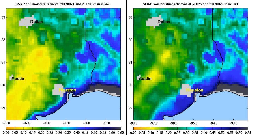
Our <a href="/NASAEarth/">NASA Earth</a> satellites continue to track #Harvey as new soil moisture data shows how it saturated areas in Texas: go.nasa.gov/2iKpO66
NASA (@nasa) 's Twitter Profile Photo

It's the #FirstDayofFall! Here's Earth today. From our vantage point in space, we work to better understand our home planet & improve lives

It's the #FirstDayofFall! Here's Earth today. From our vantage point in space, we work to better understand our home planet &amp; improve lives
NASA SMAP (@nasasmap) 's Twitter Profile Photo

SMAP Sees Sea Surface Salinity @PODAAC announced the availability of updated version 2.0 SMAP Sea Surface Salinity data from Remote Sensing Systems at a spatial resolution of 70km. smap.jpl.nasa.gov/news/1265/smap…