Mike Clay (@mike_clay) 's Twitter Profile
Mike Clay

@mike_clay

Chief Meteorologist Bay News 9, Tampa Bay. I have a live radar and I'm not afraid to use it. Follow the whole team @bn9weather

ID: 26284617

linkhttp://www.baynews9.com/content/news/baynews9/news/about/bios/mike-clay.html calendar_today24-03-2009 17:55:06

8,8K Tweet

4,4K Followers

2,2K Following

Mike Clay (@mike_clay) 's Twitter Profile Photo

Almost unheard of to get hail this size in Florida in the late morning in June. Strong vort we've been tracking across the country certainly helped. This looks bigger than quarter size (LSR so far).

Andrew Moore (@osuwxguy) 's Twitter Profile Photo

Hot off the presses - latest ECMWF June seasonal modeling shows Atlantic activity (ACE) 10% above the 1993-2024 average - with forecasts for the Atl / E Pac identical to May, with the W Pac up to 20% below normal instead of 30% below normal

Hot off the presses - latest ECMWF June seasonal modeling shows Atlantic activity (ACE) 10% above the 1993-2024 average - with forecasts for the Atl / E Pac identical to May, with the W Pac up to 20% below normal instead of 30% below normal
Andy Hazelton (@andyhazelton) 's Twitter Profile Photo

This is the lowest June ACE forecast from the seasonal ECMWF in several years. It'll be interesting to see which way the bias goes this year. During the late 2010s, the model tended to underpredict the Atlantic, but the last few years seem calibrated too high (like last year's

This is the lowest June ACE forecast from the seasonal ECMWF in several years. It'll be interesting to see which way the bias goes this year. During the late 2010s, the model tended to underpredict the Atlantic, but the last few years seem calibrated too high (like last year's
Spectrum Bay News 9 Weather (@bn9weather) 's Twitter Profile Photo

Notice the low visibility and hazy skies? This is the Saharan Dust Layer (SAL) we've been talking about for days over Florida now. We couldn't notice it yesterday because it was so cloudy anyway. This SAL will help to lower our rain chances for a few days too. #flwx

Notice the low visibility and hazy skies? This is the Saharan Dust Layer (SAL) we've been talking about for days over Florida now. We couldn't notice it yesterday because it was so cloudy anyway. This SAL will help to lower our rain chances for a few days too. #flwx
NHC_TAFB (@nhc_tafb) 's Twitter Profile Photo

Smoke caused by wildfires in #Canada has spread southward to the western Atlantic and northern Caribbean Sea. Meanwhile #Sahara Dust from Africa is also approaching the region, and these two plumes are about to meet and mix together.

Smoke caused by wildfires in #Canada has spread southward to the western Atlantic and northern Caribbean Sea. Meanwhile #Sahara Dust from Africa is also approaching the region, and these two plumes are about to meet and mix together.
Mike Clay (@mike_clay) 's Twitter Profile Photo

My last hurricane talk of the pre-season (sort of). Always a good crowd at the Hernando Co Hurricane Expo in Spring Hill #flwx

My last hurricane talk of the pre-season (sort of). Always a good crowd at the Hernando Co Hurricane Expo in Spring Hill #flwx
Mike Clay (@mike_clay) 's Twitter Profile Photo

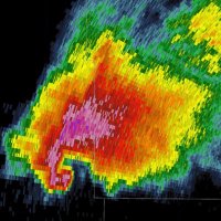
You never know what you will see in the Texas Panhandle in tornado season. I grew up on a ranch in Central TX, never seen anything like this.

Mike Clay (@mike_clay) 's Twitter Profile Photo

Reminds me of the North TX Derecho in 1989. Bow was moving SE at 70 mph! The old SEP radar had tops to 70k. spc.noaa.gov/misc/AbtDerech…

We Scored on 4th & 13 (@doc_texas) 's Twitter Profile Photo

Keith Jackson’s last game on air was 2006 Rose Bowl, USC vs Texas. Lee Corso’s last show will be Texas vs Ohio State.

GabeWx (@gabe529wx) 's Twitter Profile Photo

November 19, 1973 - Gary England warns his viewers of a strong tornado based on radar: the first radar indicated warning of a tornado