MemphisWeather.net (@memphisweather1) 's Twitter Profile
MemphisWeather.net

@memphisweather1

The best in Memphis weather for 25 years! Curated by meteorologists EP (@NWAS Digital Seal), RH & #TeamMWN. Official weather for the biggest events in Memphis!

ID: 34330530

linkhttps://linktr.ee/memphisweather1 calendar_today22-04-2009 17:11:39

122,122K Tweet

29,29K Followers

1,1K Following

MemphisWeather.net (@memphisweather1) 's Twitter Profile Photo

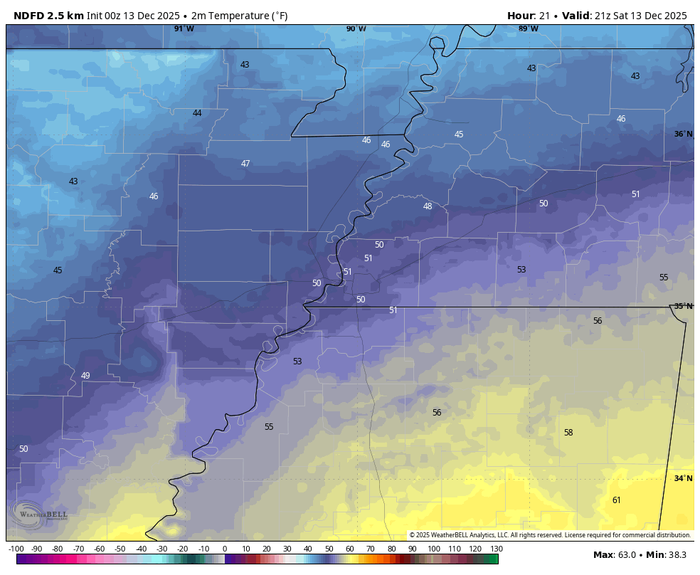
Tonight will see increasing cloud cover with lows in the mid 30s. Tomorrow will begin to turn colder, with highs in the low 50s (3pm shown). Mostly cloudy conditions are expected, and a northerly breeze may become noticeable by late evening. Enjoy tomorrow before the cool

Tonight will see increasing cloud cover with lows in the mid 30s. Tomorrow will begin to turn colder, with highs in the low 50s (3pm shown). Mostly cloudy conditions are expected, and a northerly breeze may become noticeable by late evening. Enjoy tomorrow before the cool
MemphisWeather.net (@memphisweather1) 's Twitter Profile Photo

Today's Memphis weather almanac - Avg high/low: 54/37. Record high: 76 (1984+). Record low: 5 (1962). Sunrise: 6:59am Sunset: 4:49pm #memwx

MemphisWeather.net (@memphisweather1) 's Twitter Profile Photo

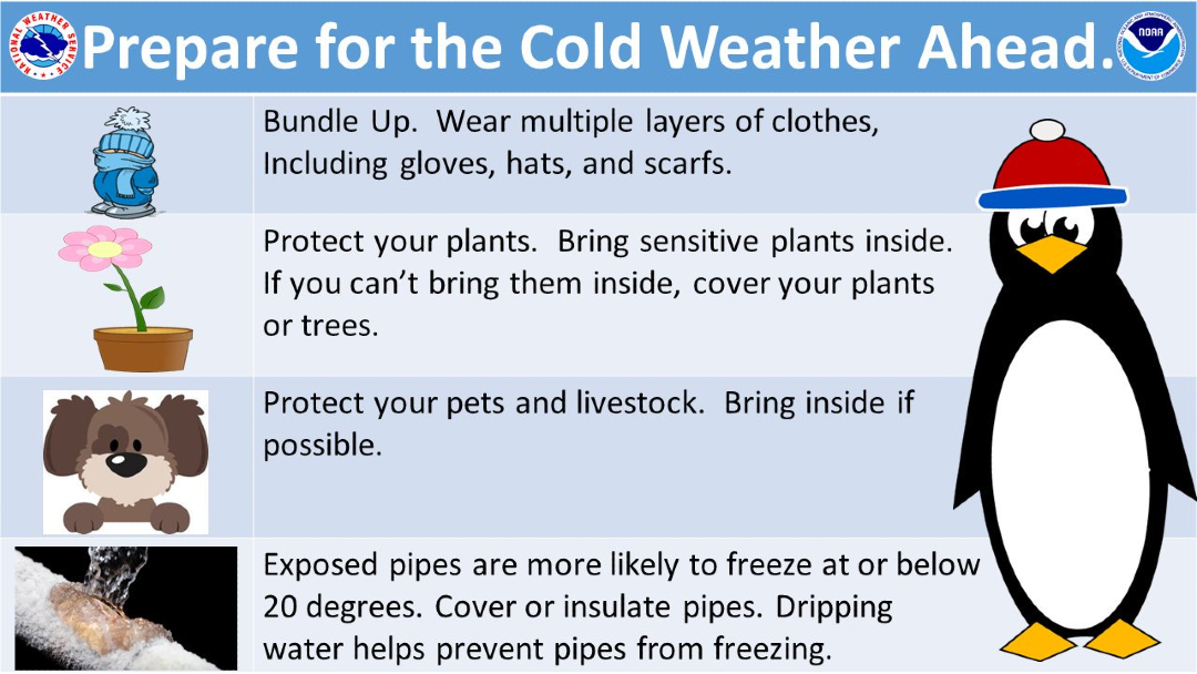
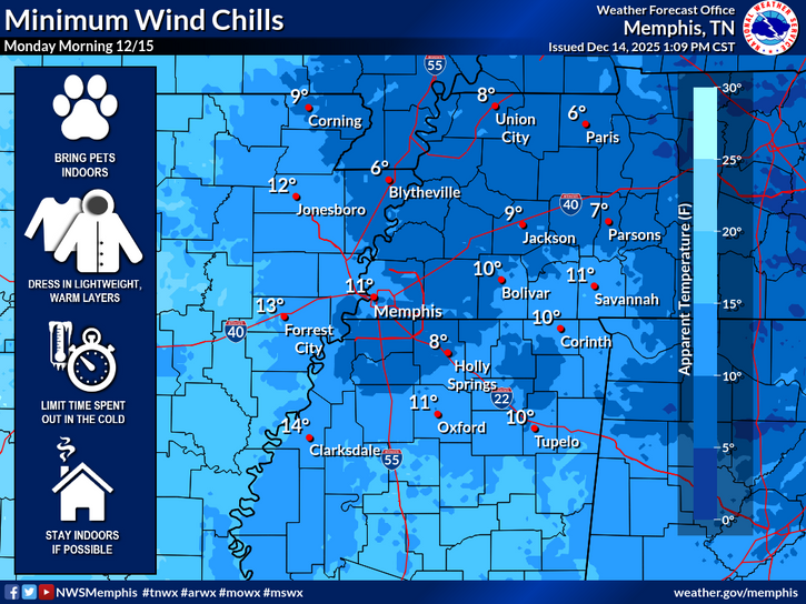
A fairly decent day is on tap, though afternoon clouds signal the leading edge of a bitterly cold airmass that arrives tonight. With a high near 50°, use today to make sure you're ready for subfreezing temps tomorrow into Monday as wind chills drop to the single digits!

A fairly decent day is on tap, though afternoon clouds signal the leading edge of a bitterly cold airmass that arrives tonight. With a high near 50°, use today to make sure you're ready for subfreezing temps tomorrow into Monday as wind chills drop to the single digits!
MemphisWeather.net (@memphisweather1) 's Twitter Profile Photo

Besides it being COLD outside, there are a few additional clues that indicate we're under the influence of an Arctic airmass: A) dewpoints near ZERO and B) pressure readings above 30.60" which indicates very strong high pressure. Bundle up tonight!

Besides it being COLD outside, there are a few additional clues that indicate we're under the influence of an Arctic airmass: 
A) dewpoints near ZERO and 
B) pressure readings above 30.60" which indicates very strong high pressure.  Bundle up tonight!
MemphisWeather.net (@memphisweather1) 's Twitter Profile Photo

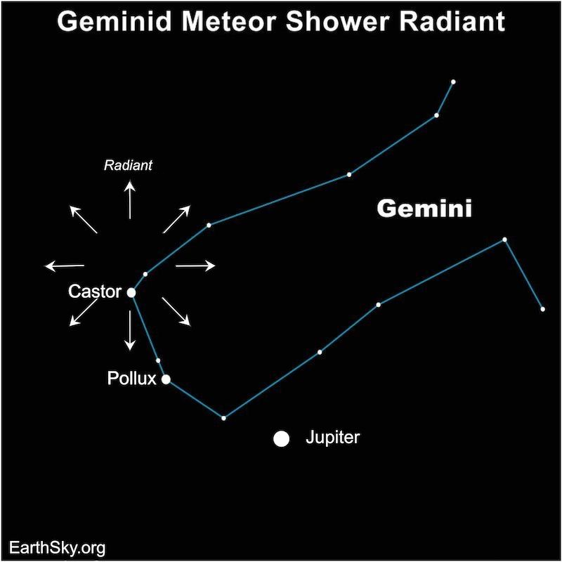
The Geminids meteor shower peaks this weekend! Meteors will radiate out from near Jupiter in the NE sky, but many are possible and they could be viewable in any direction, starting late evening and peaking about 2am. DRESS WARM! More: f.mtr.cool/yoscljfjks

The Geminids meteor shower peaks this weekend! Meteors will radiate out from near Jupiter in the NE sky, but many are possible and they could be viewable in any direction, starting late evening and peaking about 2am. DRESS WARM! More: f.mtr.cool/yoscljfjks
MemphisWeather.net (@memphisweather1) 's Twitter Profile Photo

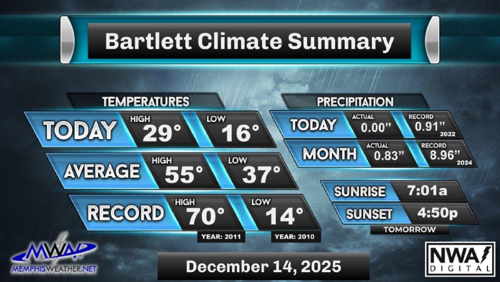
Today was a sunny but bitterly cold day across the metro. Highs stayed in the upper 20s, around 25° below average for this time of year. It has been since late February that temperatures were this low. Warmer weather is expected to start the work week.🥶 /AO

Today was a sunny but bitterly cold day across the metro. Highs stayed in the upper 20s, around 25° below average for this time of year. It has been since late February that temperatures were this low. Warmer weather is expected to start the work week.🥶 /AO
MemphisWeather.net (@memphisweather1) 's Twitter Profile Photo

Tonight will be clear and very cold. Lows will be in the teens, with wind chills dipping into the single digits. Tomorrow morning will be bitterly cold, with wind chills near 10°, so make sure to bundle up! Tomorrow’s highs will reach the upper 30s, with sunny skies expected. /AO

Tonight will be clear and very cold. Lows will be in the teens, with wind chills dipping into the single digits. Tomorrow morning will be bitterly cold, with wind chills near 10°, so make sure to bundle up! Tomorrow’s highs will reach the upper 30s, with sunny skies expected. /AO
MemphisWeather.net (@memphisweather1) 's Twitter Profile Photo

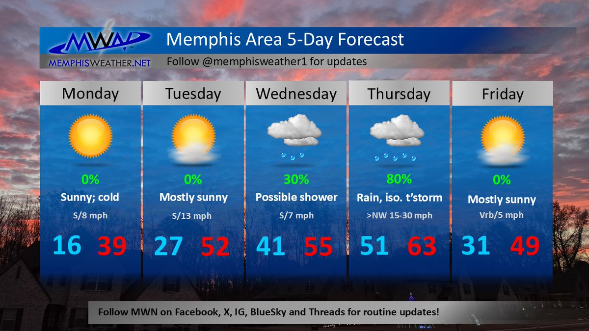
The week starts bitterly cold, but temps quickly warm to seasonal averages - or higher - for much of the week. A Thursday front brings gusty wind and even a chance of t'storms before another brief cooldown on Friday. Look for 60s again next weekend as Christmas week nears!

The week starts bitterly cold, but temps quickly warm to seasonal averages - or higher - for much of the week. A Thursday front brings gusty wind and even a chance of t'storms before another brief cooldown on Friday. Look for 60s again next weekend as Christmas week nears!
MemphisWeather.net (@memphisweather1) 's Twitter Profile Photo

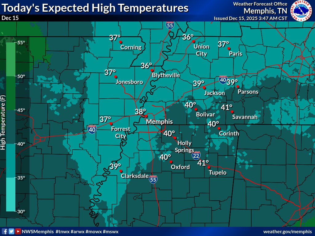
It's Monday again! Today starts with frigid temps in the 12-15° range, but the beginning of a significant warmup the next few days is marked by light south wind and full sunshine today. That will allow temps to reach the upper 30s to near 40°. By tomorrow we're back in the 50s.

It's Monday again! Today starts with frigid temps in the 12-15° range, but the beginning of a significant warmup the next few days is marked by light south wind and full sunshine today. That will allow temps to reach the upper 30s to near 40°. By tomorrow we're back in the 50s.
MemphisWeather.net (@memphisweather1) 's Twitter Profile Photo

Today's Memphis weather almanac - Avg high/low: 53/36. Record high: 75 (1984+). Record low: 2 (1901). Sunrise: 7:01am Sunset: 4:49pm #memwx