Michael Brennan (@mbrennanwx) 's Twitter Profile
Michael Brennan

@mbrennanwx

Tweets/opinions here are mine only.

ID: 148962007

calendar_today28-05-2010 02:04:30

5,5K Tweet

1,1K Followers

448 Following

NHC Eastern Pacific (@nhc_pacific) 's Twitter Profile Photo

Tropical Storm #Lidia Advisory 23: Lidia Forecast to Strength Before Landfall. Hurricane Watch Issued For Portions of West-Central Mexico. hurricanes.gov

NHC Eastern Pacific (@nhc_pacific) 's Twitter Profile Photo

Hurricane #Lidia almost a category 4 hurricane. Expected to make landfall this evening in west-central Mexico. Here are the Key Messages. Visit hurricanes.gov

Hurricane #Lidia almost a category 4 hurricane.  Expected to make landfall this evening in west-central Mexico.  Here are the Key Messages.  Visit hurricanes.gov
NHC Eastern Pacific (@nhc_pacific) 's Twitter Profile Photo

6 PM MDT Tuesday Oct 10 Update: Extremely dangerous category 4 Hurricane Lidia makes landfall in west-central Mexico. Life-threatening winds and flooding rainfall spreading inland over west-central Mexico. Full information: nhc.noaa.gov/text/refresh/M…

6 PM MDT Tuesday Oct 10 Update:  Extremely dangerous category 4 Hurricane Lidia makes landfall in west-central Mexico. Life-threatening winds and flooding rainfall spreading inland over west-central Mexico.  Full information:  nhc.noaa.gov/text/refresh/M…
NHC Eastern Pacific (@nhc_pacific) 's Twitter Profile Photo

3pm MDT Thu 19th October Key Messages for Hurricane #Norma. A Hurricane Warning is now in effect for the southern portion of the Baja California peninsula where Norma is expected to bring hurricane conditions on Saturday. hurricanes.gov/#Norma

3pm MDT Thu 19th October Key Messages for Hurricane #Norma. 

A Hurricane Warning is now in effect for the southern portion of the Baja California peninsula where Norma is expected to bring hurricane conditions on Saturday.

hurricanes.gov/#Norma
National Hurricane Center (@nhc_atlantic) 's Twitter Profile Photo

Hurricane #Tammy Advisory 10: Tammy Moving Closer to the Leeward Islands. Heavy Rainfall and Flooding Likely Over Much of the Lesser Antilles. hurricanes.gov

NHC Eastern Pacific (@nhc_pacific) 's Twitter Profile Photo

Hurricane #Norma Advisory 13: Air Force Hurricane Hunters Find Norma is a Major Hurricane. Hurricane Conditions, Flooding Rainfall, and a Dangerous Storm Surge Expected in Southern Baja California Sur. hurricanes.gov

NOAA Atlantic Oceanographic and Meteorological Lab (@noaa_aoml) 's Twitter Profile Photo

Yesterday, AOML's Hurricane Field Program successfully deployed a new uncrewed aircraft system (UAS) called, Black Swift S0, into Tropical Storm Tammy (2023) to measure parts of the storm too dangerous for humans to go. Learn more: bit.ly/46DiVa5

BarbadosMetServices (@barbadosmet) 's Twitter Profile Photo

Feeder band has developed and is affecting Barbados. Flash flood warning is in effect. Hear more in this evening's update on Hurricane Tammy by Director Sabu Best. #BePrepared #Tammy #Barbados #Weather

NHC Eastern Pacific (@nhc_pacific) 's Twitter Profile Photo

URGENT 4p CDT 10/24 - Otis has rapidly intensified into a major hurricane and is forecast to be an extremely dangerous category 4 at landfall in southern Mexico late tonight or early Wednesday. More: hurricanes.gov

URGENT 4p CDT 10/24 - Otis has rapidly intensified into a major hurricane and is forecast to be an extremely dangerous category 4 at landfall in southern Mexico late tonight or early Wednesday.  More: hurricanes.gov
NHC Eastern Pacific (@nhc_pacific) 's Twitter Profile Photo

A Special Advisory has been issued for extremely dangerous category 4 hurricane #Otis, which is forecast to be near category 5 strength at landfall. Here are the Key messages for this 7 pm Tue CDT advisory. Full details: hurricanes.gov

A Special Advisory has been issued for extremely dangerous category 4 hurricane #Otis, which is forecast to be near category 5 strength at landfall. Here are the Key messages for this 7 pm Tue CDT advisory.  Full details: hurricanes.gov
NWS Storm Prediction Center (@nwsspc) 's Twitter Profile Photo

11/19: There is an Enhanced risk (level 3/5) of severe thunderstorms on Monday (11/20) over portions of northern Louisiana and central Mississippi. Damaging winds and tornadoes (some possibly strong) are the primary concerns. For the latest forecast: spc.noaa.gov

11/19: There is an Enhanced risk (level 3/5) of severe thunderstorms on Monday (11/20) over portions of northern Louisiana and central Mississippi. Damaging winds and tornadoes (some possibly strong) are the primary concerns. For the latest forecast: spc.noaa.gov
NOAA's Ocean Service (@noaaocean) 's Twitter Profile Photo

We're monitoring water levels for the East Coast Cyclone, which are elevated from Florida to New England due to this significant weather event: tidesandcurrents.noaa.gov/inundationdb/s… Your local National Weather Service has the latest safety information. Find them at weather.gov/socialmedia #TurnAroundDontDrown
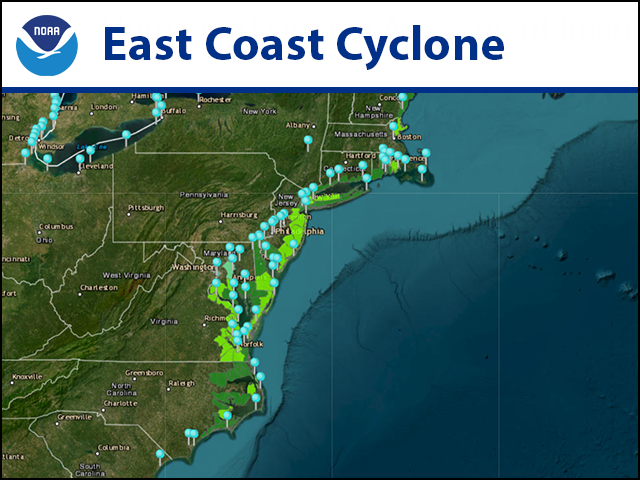
We're monitoring water levels for the East Coast Cyclone, which are elevated from Florida to New England due to this significant weather event:
tidesandcurrents.noaa.gov/inundationdb/s…
Your local <a href="/NWS/">National Weather Service</a> has the latest safety information. Find them at weather.gov/socialmedia #TurnAroundDontDrown
NWS Mobile (@nwsmobile) 's Twitter Profile Photo

🌪 Nighttime Storm Safety Reminders... ✅ Have multiple ways to receive warnings, including one that WAKE YOU UP ✅ Charge your cellphone before you go to bed ✅ Ensure the volume on your cellphone is turned up ✅ Your cellphone should NOT be set to silent or "do not disturb"

NWS Los Angeles (@nwslosangeles) 's Twitter Profile Photo

We are expecting a major storm with dangerous, even life-threatening impacts! Here is a short list of what's coming and how you can prepare for and avoid hazards, including heavy rain and dangerous flooding, heavy mountain snow and strong, damaging winds. #CAwx

We are expecting a major storm with dangerous, even life-threatening impacts! Here is a short list of what's coming and how you can prepare for and avoid hazards, including heavy rain and dangerous flooding,  heavy mountain snow and strong, damaging winds. #CAwx
NWS Storm Prediction Center (@nwsspc) 's Twitter Profile Photo

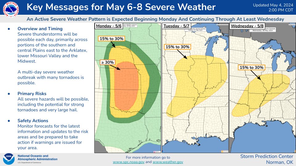
05/04/2024 2:16 PM CDT: A multi-day severe weather outbreak is expected this upcoming Monday-Wednesday. Intense tornadoes will be possible. Now is the time to make or review your severe weather safety plans. Stay tuned for updates at spc.noaa.gov/products/outlo…

05/04/2024 2:16 PM CDT: A multi-day severe weather outbreak is expected this upcoming Monday-Wednesday. Intense tornadoes will be possible. Now is the time to make or review your severe weather safety plans. Stay tuned for updates at spc.noaa.gov/products/outlo…
NWS Storm Prediction Center (@nwsspc) 's Twitter Profile Photo

Numerous severe thunderstorms remain likely Monday afternoon into the overnight hours across the central & southern Great Plains. All hazards will be possible, including the potential for strong tornadoes. Take time today to consider your severe-weather safety plan for tomorrow.

Numerous severe thunderstorms remain likely Monday afternoon into the overnight hours across the central &amp; southern Great Plains. All hazards will be possible, including the potential for strong tornadoes. Take time today to consider your severe-weather safety plan for tomorrow.
NWS Storm Prediction Center (@nwsspc) 's Twitter Profile Photo

5/5/2024 6:42 PM CDT: Significant severe weather is still expected across portions of the Plains states tomorrow, including the potential for strong tornadoes. Please make or review your severe weather safety plans, and stay tuned for forecast updates at spc.noaa.gov/products/outlo…

5/5/2024 6:42 PM CDT: Significant severe weather is still expected across portions of the Plains states tomorrow, including the potential for strong tornadoes. Please make or review your severe weather safety plans, and stay tuned for forecast updates at spc.noaa.gov/products/outlo…
National Weather Service (@nws) 's Twitter Profile Photo

Explosive Thunderstorm development is expected within this Particularly Dangerous Situation (PDS) Tornado Watch across parts of TX, OK, and KS this afternoon. PDS tornado watches are only issued when multiple strong or violent tornadoes are expected to occur.

National Hurricane Center (@nhc_atlantic) 's Twitter Profile Photo

8p EDT 6/26 - The Tropics are picking up again. A system in the E Atlantic (AL95) could become a tropical depression or storm this weekend several hundred miles E of the Windward Islands. A wave (AL94) also has a low chance of formation over the SW Gulf Mexico late this week.

8p EDT 6/26 - The Tropics are picking up again.  A system in the E Atlantic (AL95) could become a tropical depression or storm this weekend several hundred miles E of the Windward Islands.  A wave (AL94) also has a low chance of formation over the SW Gulf Mexico late this week.