Beating The Bounds
@ldn_boundaries
Study group for boundary markers, maps and insignia of (mostly vanished) local authorities in the Metropolis (AKA London).
ID: 1534190173809950720
07-06-2022 15:07:16
448 Tweet
584 Followers
295 Following
 on Twitter photo St Pancras (SPL) and St George Bloomsbury (SGB) in the county of Middlesex and administrative county of London from 1889. SGB merged into MB of #Holborn in 1900 and boundary moved West. Note the additional StPPM marker. Wakefield St WC1N, today LB of #Camden")
 on Twitter photo Pavement boundary marker for St Luke Middlesex (StLM). Boundary with City of London/St Giles without Cripplegate on Fann St EC1")
 on Twitter photo Civil parishes of Surrey in 1888, just a year before the northern parishes were grouped into the administrative County of London. The maps also shows 'Sanitary Districts'. The Local Government Act 1894 replaced these with more general local authorities (rural and urban districts)")
Map based on a 1735 survey of the parish of Islington, showing boundary features such as Maiden Lane (now York Way) and Boarded River Lane (Green Lanes). #islington Islington Local History Centre Islington Council
 on Twitter photo Map based on a 1735 survey of the parish of Islington, showing boundary features such as Maiden Lane (now York Way) and Boarded River Lane (Green Lanes). #islington <a href=\"/IslingtonLHC/\">Islington Local History Centre</a> <a href=\"/IslingtonBC/\">Islington Council</a>")
 on Twitter photo Greenwich foot tunnel midpoint: historic parish and county boundary of Poplar (Middlesex) and Greenwich (Kent). Today boundary between London Borough of Tower Hamlets and Royal Borough of Greenwich.")
 on Twitter photo Large parts of Stoke Newington used to be part of Hornsey. 3 exclaves (detached parts) formed the local government district of South Hornsey, run by South Hornsey Urban District council. In 1900 the area was absorbed into the newly created Metropolitan Borough of Stoke Newington")
 on Twitter photo Replacement boundary stone for the Metropolitan Borough of Lewisham (1900-1965) at Blackheath station. Just north of the station the historic parishes of Lewisham, Lee and Charlton meet. #lewisham")
 's Twitter Profile Photo")
 on Twitter photo #AlphabetChallenge #WeekP.
P is for Parish Boundary Marker
These can be spotted around the City of London, but the real challenge for most of us is trying to figure out what the letters might stand for ...")
 's Twitter Profile Photo")
1822 Stoke Newington/Hackney parish boundary marker is in Hackney Museum. I do wonder where it would have originally been situated 202 years ago. (cc: Beating The Bounds)
 on Twitter photo 1822 Stoke Newington/Hackney parish boundary marker is in <a href=\"/HackneyMuseum/\">Hackney Museum</a>. I do wonder where it would have originally been situated 202 years ago. (cc: <a href=\"/Ldn_Boundaries/\">Beating The Bounds</a>)")
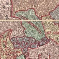
 on Twitter photo map of the old parliamentary borough of Finsbury (Middlesex), created in 1832. It included parishes such as Islington, Stoke Newington, Bloomsbury, Holborn and Clerkenwell (excluding its Muswell Hill exclave). Initially, Finsbury had 2 MPs in the House of Commons")
Boundary marker expert Beating The Bounds has concluded the rare 1822 triangle parish boundary marker was next to the former Sutton Arms pub where the three parishes (Stoke Newington, Hackney and Islington) and created this handy visual to illustrate the boundary of each of them.
 on Twitter photo Boundary marker expert <a href=\"/Ldn_Boundaries/\">Beating The Bounds</a> has concluded the rare 1822 triangle parish boundary marker was next to the former Sutton Arms pub where the three parishes (Stoke Newington, Hackney and Islington) and created this handy visual to illustrate the boundary of each of them.")
What a thrill it was just now going with Beating The Bounds (right) to see the Hornsey Parish boundary marker from 1887 in the back garden of a house on Albion Road, where the boundary between Stoke Newington and one of Hornsey parish’s detached sections was until 1900. Such
 on Twitter photo What a thrill it was just now going with <a href=\"/Ldn_Boundaries/\">Beating The Bounds</a> (right) to see the Hornsey Parish boundary marker from 1887 in the back garden of a house on Albion Road, where the boundary between Stoke Newington and one of Hornsey parish’s detached sections was until 1900.
Such")
 on Twitter photo Boundary marker for the Strand district on Wardour Street. Strand was a local government district from 1855 until 1900 when metropolitan boroughs were created in the County of London")
 's Twitter Profile Photo")
 on Twitter photo Some parish boundary markers are hard to find as parts are buried deep below street level, but even if that's the case as here, if there's no overgrown hedgerows they are still clear indications of extent of historic parish
#GipsyHill
#Lambeth
#Southwark
#BeatingTheBounds")
 's Twitter Profile Photo")
Lovely half submerged boundary marker MyattsFieldsPark Alison Rae with #Camberwell St Giles icon. 1870, pre park, now in #Lambeth
 on Twitter photo Lovely half submerged boundary marker <a href=\"/myattsfields/\">MyattsFieldsPark</a> <a href=\"/alisonmkrae/\">Alison Rae</a> with #Camberwell St Giles icon. 1870, pre park, now in #Lambeth")
 's Twitter Profile Photo")
 on Twitter photo Parish boundary marker for St Margaret Westminster at Kensington Gore, by the Royal Albert Hall.")
 's Twitter Profile Photo")
 on Twitter photo Unnoticed by the majority of passersby at the bottom of the stairs leading up to Waterloo Bridge, on the Somerset House side, is the boundary marker showing the historical boundary of the Manor of Savoy, that became part of the Duchy of Lancaster.")
 's Twitter Profile Photo")
 on Twitter photo 1893 Cast Iron Boundary Marker Sign Parish of St John at Hackney featuring names of the Churchwardens.")
 on Twitter photo Detective work required at Warley St, Bethnal Green, London. The street contains several bricked-up arches beneath the railway tracks. One arch has a post built onto it with a commemorative stone in two halves containing letters and the dates 1885. Any ideas?")