KeviShader
@kevishader
Providing information on tropical cyclones and severe weather events.
ID: 515668867
05-03-2012 17:18:52
11,11K Tweet
3,3K Followers
358 Following
 's Twitter Profile Photo")
 on Twitter photo I've added the Meteosat Third Generation Imager 1 satellite, with images every 10 minutes and higher resolution data in line with Himawari-9 and the GOES satellites. Will be very useful this upcoming season to monitor tropical waves and watch disturbances in the eastern Atlantic!")
 's Twitter Profile Photo")
 on Twitter photo Despite the persisting cold anomalies near the dateline, I would say that the ongoing La Niña event has come to a conclusion. The SSTs in the tropical Pacific are far more consistent with a strong -PMM signature projecting onto the ENSO regions than a true La Niña right now.")
 's Twitter Profile Photo")
 's Twitter Profile Photo")
Dennis Moos lives in Grinnell, Kansas. He says he was watching #KAKEnews weather coverage on Sunday and saw that Jay Prater, CBM KAKE was pointing to his town. He opened his front door to this. 🌪😨 #KAKEnews #KSwx #Grinnell #GoveCounty #Kansas #tornado
 's Twitter Profile Photo")
 on Twitter photo Cyclone #Vince from earlier this year, sampled by the EarthCARE satellite!")
 's Twitter Profile Photo")
 's Twitter Profile Photo")
 on Twitter photo Newest recon pass into #Hurricane #Erin's formative eye shows that the EXTR pressure has dropped to 993.6mb. That is about 2mb lower than the previous pass from this plane (AF308) about 1h 10min ago (995.7mb prev. pass). #Erin is deepening.")
 's Twitter Profile Photo")
 on Twitter photo Early morning recon confirms that #Erin is undergoing rapid intensification and is now a major hurricane with winds of ~125 mph. The extrapolated pressure has cratered to 947mb.")
 on Twitter photo Incredible intensification from #Erin during the past 24h. The latest recon pass found winds supporting at least 110KT/125mph with an extr pressure of ~947mb, around 50mb lower than yesterday (and about 55KT stronger!).")
 's Twitter Profile Photo")
 on Twitter photo Holy cow! Drifting buoy \"7810602\" measuring a 900.3 mb MSLP right at the center of Supertyphoon #Ragasa (#NandoPH) as of 08Z! This has gotta be the lowest pressure ever recorded by a buoy in a TC!")
 's Twitter Profile Photo")
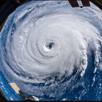
Hurricane Humberto, Cat 4 (at the time taken), from the International Space Station, Sept 27, 1512 GMT. Nikon Z9 | 24/50-500mm.
 on Twitter photo Hurricane Humberto, Cat 4 (at the time taken), from the <a href=\"/Space_Station/\">International Space Station</a>, Sept 27, 1512 GMT. Nikon Z9 | 24/50-500mm.")
 's Twitter Profile Photo")
 on Twitter photo 眼です。")