GISOpenCourseWare @gisocw@fosstodon.org (@gisocw) 's Twitter Profile
GISOpenCourseWare @[email protected]

@gisocw

Platform for sharing #GIS #OpenCourseWare.
#OCW #OpenEducation #OER #geospatial #OpenSource #QGIS #Python. Powered by @ihedelft. Moderated by @hansakwast.

ID: 1311905835577212928

linkhttps://courses.gisopencourseware.org calendar_today02-10-2020 05:48:48

3,3K Tweet

3,3K Followers

138 Following

#geoObserver 🌍🔭@geoObserver@mastodon.social (@geoobserver_) 's Twitter Profile Photo

Maps Mania: Die Wasserstraßenkarte / The WaterwayMap geoobserver.de/2024/12/17/map… #WaterwayMap #osm #openstreetmap #gistribe #gischat #fossgis #foss4g #OSGeo #spatial #geospatial #mapping #DataViz #gis #geo #geoObserver pls RT via Maps Mania
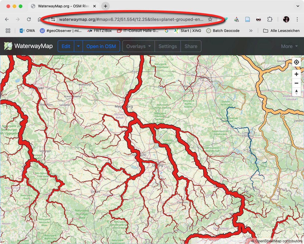
Maps Mania: Die Wasserstraßenkarte / The WaterwayMap geoobserver.de/2024/12/17/map… #WaterwayMap #osm #openstreetmap #gistribe #gischat #fossgis #foss4g #OSGeo #spatial #geospatial #mapping #DataViz #gis #geo #geoObserver pls RT via <a href="/gmapsmania/">Maps Mania</a>
Amirhossein Ahrari (@enginn3r) 's Twitter Profile Photo

#EarthEngine Applications about #Drought and #Dust: - Drought Monitoring: youtu.be/i1TkiMMK-OU - Droutgh Mapping: youtu.be/TwesbdGkL1M - Drought Classification: youtu.be/TwesbdGkL1M - Dust Mapping: youtu.be/-7y1C2zRo-s - Dust Event: youtu.be/atRMDr32Pko

Amirhossein Ahrari (@enginn3r) 's Twitter Profile Photo

#EarthEngine Tutorials Published in Dec 2024: - Mann-Kendall Trend: youtu.be/Fb4whz4lz8s - River Level: youtu.be/lDRLmZHTtrY - #SAR Vegetation Index: youtu.be/qpirvICgpCU - Speckle Filtering: youtu.be/WMBD9J8UhMw - #Heat Wave: youtu.be/QvfN85UgPLA

Hans van der Kwast @hansakwast@fosstodon.org (@hansakwast) 's Twitter Profile Photo

📹 Check out my final video of 2024! Learn about custom workflows for stream & catchment delineation in #QGIS with tools from #GRASS, #SAGA, #PCRaster & #WhiteboxTools. 🌍💡Discover the benefits of #OpenSource tools over proprietary software. #QGIS #GIS youtu.be/s57P3GZTOTA

Hans van der Kwast @hansakwast@fosstodon.org (@hansakwast) 's Twitter Profile Photo

New video! Explore the ArcGeek Calculator plugin by El blog de franz to map streams & catchments, analyze their #morphometry, and create hypsometric curves in #QGIS. 🌍📊 youtu.be/9ItZ7R0KN74 #QGISHydro #GIS #Hydrology #CatchmentAnalysis

Hans van der Kwast @hansakwast@fosstodon.org (@hansakwast) 's Twitter Profile Photo

New video: segment anything in #QGIS with the Geo-SAM plugin. With examples to segment solar panels in cities and parcels in rural areas. #GeoAI #AI #GIS #RemoteSensing youtu.be/GSKmK7qERUw

Helen McKenzie (@helenmakesmaps) 's Twitter Profile Photo

After making a massive $7.19 in 4 months (less than the $10 payout threshold), I've decided to start ungating my Medium-hosted tutorials (it's not really in the knowledge-sharing spirit anyway!) and migrate them to my website, starting with... helenmakesmaps.com/post/how-to-ma…

Journées QGIS utilisateurs Francophones (@journeesqgis) 's Twitter Profile Photo

Pour vous permettre de réaliser votre nouvelle bonne résolution de participer à la communauté #QGIS, nous prolongeons l'appel à proposition au 29/01! On compte sur vous! talks.osgeo.org/qgis-french-us… #QGISFR2025

Qiusheng Wu (@giswqs) 's Twitter Profile Photo

🌍 Leafmap Tutorial 103: Adding a custom colormap to a raster image! 📹 Watch the Video: youtu.be/FIOmNsf_A5o 📓 Explore the Notebook: leafmap.org/notebooks/103_… #Geospatial #Leafmap #Python #DataViz

🌍 Leafmap Tutorial 103: Adding a custom colormap to a raster image!

📹 Watch the Video: youtu.be/FIOmNsf_A5o
📓 Explore the Notebook: leafmap.org/notebooks/103_…

#Geospatial #Leafmap #Python #DataViz
Hans van der Kwast @hansakwast@fosstodon.org (@hansakwast) 's Twitter Profile Photo

New Video: Exploring the Kue plugin: an #AI Chatbot for #QGIS by Bunting Labs 🗺 🌍✨ Simplify geoprocessing tasks with AI. Highlights: installation, base maps, styling, analyses & more. 🔔 Subscribe for more! #QGIS #AI #GeoAI #GIS youtu.be/hQJ1SuyyvT8

GeoSolutions 🇮🇹 🇺🇸 🇪🇺 🔝 (@geosolutions_it) 's Twitter Profile Photo

🌟 Missed our webinar on #GeoNode on version 4.4?No worries! 🎥 🗺️ Dive into exciting new features: ✨ Support for 3D Tiles and Assets 🔌 The new QGIS Plugin for enhanced workflows 🛠️ Bug fixes and performance improvements 👉 Check out the recording and slides on our blog

🌟 Missed our webinar on #GeoNode on version 4.4?No worries! 🎥

🗺️ Dive into exciting new features:
✨ Support for 3D Tiles and Assets
🔌 The new QGIS Plugin for enhanced workflows
🛠️ Bug fixes and performance improvements

👉 Check out the recording and slides on our blog
Aditya Dahiya (@adityadahiyaias) 's Twitter Profile Photo

#dataviz #ClimateAction A facet graph for drought severity (PDSI) in India with #opensource #raster data. Full Code🔗bit.ly/4aF3mRT Data: climatologylab.org by John Abatzoglou Emily Williams @dmitri_climate thru {climateR} Tools #rstats #ggplot2 #sf #terra #tidyterra
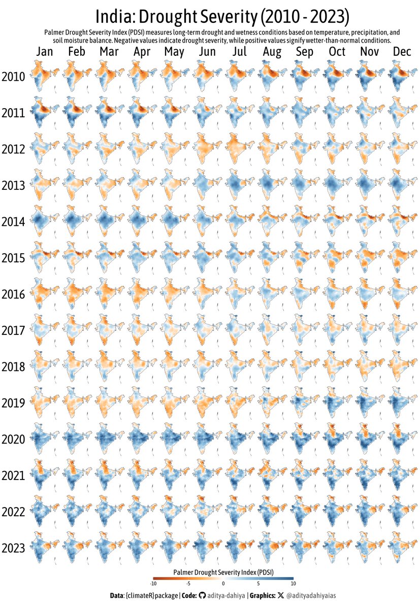
#dataviz #ClimateAction A facet graph for drought severity (PDSI) in India with #opensource #raster data.
Full Code🔗bit.ly/4aF3mRT
Data: climatologylab.org by <a href="/climate_guy/">John Abatzoglou</a> <a href="/EmilyLyWilliams/">Emily Williams</a> @dmitri_climate thru {climateR}
Tools #rstats #ggplot2 #sf #terra #tidyterra
NASAEarthdata (@nasaearthdata) 's Twitter Profile Photo

📢Data Training Webinar 2/19📢 Join us to learn how to work with ICESat-2 land and vegetation height data. A live SlideRuleEarth web service demo will show you how to use on-demand science data processing for ICESat-2 & other data. Info/Register: go.nasa.gov/40VWxIr

📢Data Training Webinar 2/19📢
Join us to learn how to work with <a href="/NASA_ICESat2/">ICESat-2</a>  land and vegetation height data. A live SlideRuleEarth web service demo will show you how to use on-demand science data processing for ICESat-2 &amp; other data. 

Info/Register: go.nasa.gov/40VWxIr
PYOFLIFE.COM (@parajulisaroj16) 's Twitter Profile Photo

Visualizing and analyzing environmental change is an important application of Geographic Data Science with R. pyoflife.com/geographic-dat… #DataScience #rstats #DataScientists #statistics #mathematics #spatialanalysis #datavisualizations #climatechange

Visualizing and analyzing environmental change is an important application of Geographic Data Science with R. pyoflife.com/geographic-dat…
#DataScience #rstats #DataScientists #statistics #mathematics #spatialanalysis #datavisualizations #climatechange
Hans van der Kwast @hansakwast@fosstodon.org (@hansakwast) 's Twitter Profile Photo

New video: explore deep learning models in #QGIS with the Deepness plugin. Segment or detect features from #RemoteSensing images. #GeoAI #MachineLearning #GIS youtu.be/xCKVqjeihbU