Frank Pichel (@frank_pichel) 's Twitter Profile
Frank Pichel

@frank_pichel

Land information specialist working to manage PLACE Community

ID: 1329316562

linkhttps://www.thisisplace.org/ calendar_today05-04-2013 14:18:32

1,1K Tweet

1,1K Followers

908 Following

Ranga.🇿🇼 (@rangamberi) 's Twitter Profile Photo

“Let me stop you right there…” Caribbean nation Guyana is booming after discovering oil. BBC’s Stephen Sackur puts it to President President Dr Irfaan Ali; lobbyists say oil is bad for the climate. Dude wasn’t having it. Mans was ready!

Frank Pichel (@frank_pichel) 's Twitter Profile Photo

We are working PLACE to create a data trust of #mapping data in partnership with data started governments - a nuanced approach that is difficult to explain. mapguy has done a great job capturing our model in the latest Map Happenings - give a read! maphappenings.com

Frank Pichel (@frank_pichel) 's Twitter Profile Photo

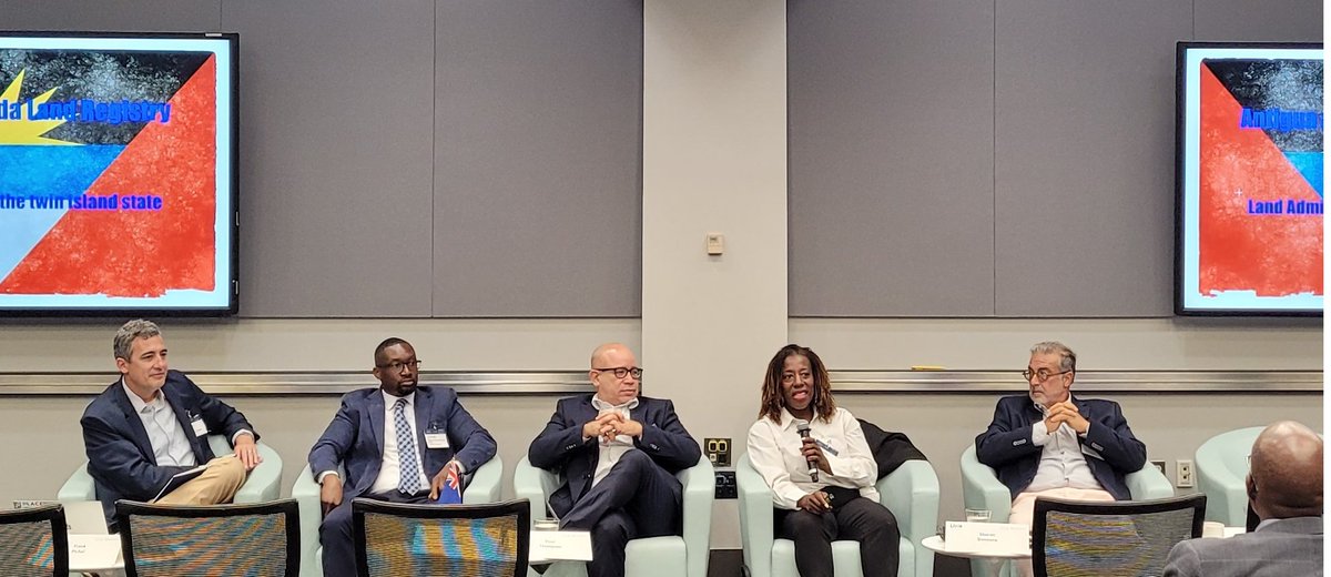
Thanks to the panelists leading national land agencies in Belize, Turks & Caicos, Anguilla and Antigua & Barbuda, and our partners Spatial Dimension | Landfolio for taking part in the "Technology for Disaster Response, Recovery, and Resiliency in Island Nation States" World Bank #landconf2024
Thanks to the panelists leading national land agencies in Belize, Turks &amp; Caicos, Anguilla and Antigua &amp; Barbuda, and our partners <a href="/SD_Landfolio/">Spatial Dimension | Landfolio</a> for taking part in the  "Technology for Disaster Response, Recovery, and Resiliency in Island Nation States" <a href="/WorldBank/">World Bank</a> #landconf2024
Frank Pichel (@frank_pichel) 's Twitter Profile Photo

Curious what it looks like when national #mapping agencies partner with PLACE to capture #spatial data? Read about how the #Anguilla #survey department worked with PLACE and see how they are using the #imagery. thisisplace.org/anguilla_2023/

Frank Pichel (@frank_pichel) 's Twitter Profile Photo

How to ensure critical data needed for #climate action is accessible, reliable, and up to date? #DataTrusts provide one approach - check out research from Digital Impact Alliance hi-lighting PLACE ow.ly/NKgO50Sq4Sf

Frank Pichel (@frank_pichel) 's Twitter Profile Photo

The impact #AI is having on the #mapping sector when high quality base data is available can't be overstated. Check out how some of our national partners are applying #ML to PLACE data in an effort to address #climatechange challenges storymaps.arcgis.com/stories/9c01fa…

The impact #AI is having on the #mapping sector when high quality base data is available can't be overstated. Check out how some of our national partners are applying #ML to PLACE data in an effort to address #climatechange challenges storymaps.arcgis.com/stories/9c01fa…
Frank Pichel (@frank_pichel) 's Twitter Profile Photo

From #urban centres in Africa, to island wide coverage in small island states, we've had a great year of data collection for the PLACE Community. Streetview imagery is now up for use by our members - find out more thisisplace.org/place-ground-c…

Frank Pichel (@frank_pichel) 's Twitter Profile Photo

While the PLACE team isn't attending the Global Digital Public Infrastructure Summit in Cairo this week - I'm glad we could contribute in the way we do best.... by creating a map. Take a look at the interactive map of national progress with critical #DPI dpimap.org/dpimap

UCL Institute for Innovation and Public Purpose (@iipp_ucl) 's Twitter Profile Photo

🧩There is an incomplete picture of the global state of DPI. To fill this gap, IIPP has launched the DPI Map which allows users to explore the digital systems that are reshaping public service delivery around the world. 🔗Read more here: medium.com/iipp-blog/digi…

🧩There is an incomplete picture of the global state of DPI.

To fill this gap, IIPP has launched the DPI Map which allows users to explore the digital systems that are reshaping public service delivery around the world. 

🔗Read more here: medium.com/iipp-blog/digi…
Esri Blog (@esriblog) 's Twitter Profile Photo

Rising seas threaten the Pacific island nation of Tuvalu and the country's leaders are taking action. A digital twin—created with GIS and high-resolution imagery captured by PLACE—help study climate impacts and preserve cultural heritage. esri.com/about/newsroom…

Rising seas threaten the Pacific island nation of Tuvalu and the country's leaders are taking action. A digital twin—created with GIS and high-resolution imagery captured by <a href="/ThisIsPLACE/">PLACE</a>—help study climate impacts and preserve cultural heritage. esri.com/about/newsroom…
Landstack (@center4land) 's Twitter Profile Photo

'The initiative opens opportunities to adopt agroforestry & equitable ecologically sustainable farming on land where individual forest rights are recognized utilizing expedited mapping supported by Cadasta Foundation' Pranab Choudhury of Landstack shorturl.at/rMc5u

Senator Chris Van Hollen (@chrisvanhollen) 's Twitter Profile Photo

As we witness horrific scenes in El-Fasher, the UAE continues arming the RSF — which the U.S. has determined is committing genocide.   Enough. We must pass my bill to block arms sales to the UAE until it stops fueling the RSF's war crimes in Sudan. wsj.com/world/how-u-a-…