mathieu rajerison (@datagistips) 's Twitter Profile
mathieu rajerison

@datagistips

Fun with #qgis #rstats 🦖
Cartomaticien @OSMdata 🌍
DiGIStal @ceremaCom 🌱
Starting #MapFailbruaryChallenge 🤪
#FrugaliTek 🐣
views are my own

ID: 488000929

linkhttp://datagistips.hypotheses.org calendar_today09-02-2012 23:46:12

10,10K Tweet

2,2K Followers

957 Following

Yan Holtz (@r_graph_gallery) 's Twitter Profile Photo

Quarto is 100x better than Jupyter IMO 🙈 1️⃣ Reproducibility Jupyter lets you rerun chunks inconsistently 😳 2️⃣ Advanced Formatting Quarto = full control over output styles. Styling Jupyter is a Nightmare. 3️⃣ Version Control .qmd are plain text, not .ipynb Ever tried it?

Quarto is 100x better than Jupyter IMO 🙈

1️⃣ Reproducibility
Jupyter lets you rerun chunks inconsistently 😳

2️⃣ Advanced Formatting
Quarto = full control over output styles. Styling Jupyter is a Nightmare.

3️⃣ Version Control
 .qmd are plain text, not .ipynb

Ever tried it?
VideoLAN (@videolan) 's Twitter Profile Photo

VLC automatic subtitles generation and translation based on local and open source AI models running on your machine working offline, and supporting numerous languages! Demo can be found on our #CES2025 booth in Eureka Park.

Min Choi (@minchoi) 's Twitter Profile Photo

Wow, kind of wild that you can now generate a 3D Gaussian splat from just a single image or multiple images. Game changer for 3D modeling. Check out these examples:

Grant Kot (@kotsoft) 's Twitter Profile Photo

Tokyo point cloud: Continuous/fast travel between all regions, as well as imported some geometry through the CityGML data. Working on integrating Mapillary street images to improve the building sides. (Using my own Cloudflare R2 bucket and CF Cache to deliver data)

Martin Picard (@mitopsychobio) 's Twitter Profile Photo

Every second, trillions of flowing cells transporting oxygen to your respiring mitochondria The blood is the bridge between breath and flowing electrons in your mitochondria So beautiful !

Ian George (@scannerian1) 's Twitter Profile Photo

Monmouth centre as a #GaussianSplat render in polycam from a #photogrammetry dataset. I love the field of view effect #Suersplat (PlayCanvas) editor makes. It’s like that #Hitchcock camera shot from Vertigo.

Jean-Louis ZIMMERMANN ن (@jlzimmermann) 's Twitter Profile Photo

Pour tester le niveau de complétude de la donnée OpenStreetMap sur la marchabilité sur votre commune, il y a osmarche.someware.fr/explore L'approche est ingénieuse : identifier ce qui est saisi et ce qui est qualifié. Paris est exemplaire car il y a des trottoirs partout.

Pour tester le niveau de complétude de la donnée OpenStreetMap sur la marchabilité sur votre commune, il y a osmarche.someware.fr/explore
L'approche est ingénieuse : identifier ce qui est saisi et ce qui est qualifié. Paris est exemplaire car il y a des trottoirs partout.
mathieu rajerison (@datagistips) 's Twitter Profile Photo

Le Parc National des Calanques Parc national des Calanques recherche sa/son futur/e chargé/e de mission SIG 🌍🌊🐦 calanques-parcnational.fr/fr/offres-demp… #emploi #gistribe


ア (@yuruyurau) 's Twitter Profile Photo

a=(x,y,d=mag(k=9*cos(x/8),e=y/8-12.5)**2/99+sin(t)/6+.5)=>point((q=99-e*sin(atan2(k,e)*7)/d+k*(3+cos(d*d-t)*2))*sin(c=d/2+e/69-t/16)+200,(q+19*d)*cos(c)+200) t=0,draw=$=>{t||createCanvas(w=400,w);background(9).stroke(w,66);for(t+=PI/45,i=1e4;i--;)a(i%200,i/55)}#つぶやきProcessing

Cerema (@ceremacom) 's Twitter Profile Photo

🗞️"Sur les #friches industrielles, faire grandir la #ville sans rogner les champs" L'Express "Dans les #HautsdeFrance marqués par la désindustrialisation, plus de 3.000 sites ont été recensés par la plateforme nationale #Cartofriches" du #Cerema. lexpress.fr/societe/sur-le… #Foncier

Sylvain Genevois (@mirbole01) 's Twitter Profile Photo

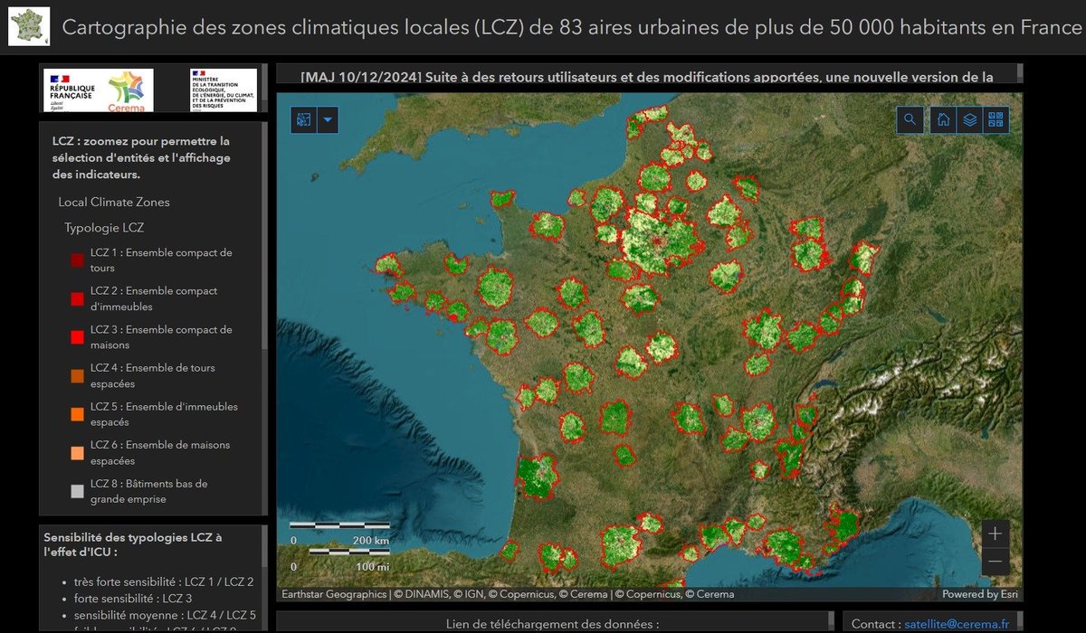
Cartographie des Zones Climatiques Locales (LCZ) dans les aires urbaines françaises Le Cerema met à disposition l’outil Zones climatiques locales qui permet d’accéder aux données et cartes indiquant le degré d’exposition au phénomène d’îlot de chaleur cartonumerique.blogspot.com/2025/06/cartog…

Cartographie des Zones Climatiques Locales (LCZ) dans les aires urbaines françaises
Le Cerema met à disposition l’outil Zones climatiques locales qui permet d’accéder aux données et cartes indiquant le degré d’exposition au phénomène d’îlot de chaleur
cartonumerique.blogspot.com/2025/06/cartog…
Gilles Babinet (@babgi) 's Twitter Profile Photo

Un papier de fond dans les Échos aujourd'hui sur le Lydex, le lycée d'excellence marocain de l'Um6p qui sature littéralement le coucours international des grandes écoles, et nous rappelle la panne de la méritocratie française. Papier que la direction de l'EN devrait lire

Un papier de fond dans les Échos aujourd'hui sur le Lydex,  le lycée d'excellence marocain de l'Um6p qui sature littéralement le coucours international des grandes écoles, et nous rappelle la panne de la méritocratie française.
Papier que la direction de l'EN devrait lire
mathieu rajerison (@datagistips) 's Twitter Profile Photo

✍️ Reprise de l'écriture avec une réflexion sur l'annotation pour la #GeoIA depuis #QGIS vis-à-vis de l'annotation classique pour l'IA avec Label Studio. datagistips.hypotheses.org/722 #gistribe #geotribu #QGIS #GeoIA

mathieu rajerison (@datagistips) 's Twitter Profile Photo

Second article autour de la transformation de #QGIS en station d'annotation performante pour l'IA 🤖 sur l'exemple des parkings 🚗🚗🚗. datagistips.hypotheses.org/1218 ✏️J'ai fait des petits dessins et essayé d'insérer des petites touches d'humour. #QGIS #geotribu #IA #annotation