Christina Shintani (@cmshintani) 's Twitter Profile
Christina Shintani

@cmshintani

Cartographer @WoodwellClimate previously @NatGeoMag | Backpacker | she/her

ID: 1207743570884616196

linkhttp://shintanimaps.com calendar_today19-12-2019 19:24:47

174 Tweet

606 Followers

491 Following

Woodwell Climate Research Center (@woodwellclimate) 's Twitter Profile Photo

The Yukon Flats National Wildlife Refuge contains 3.9 million acres of ancient, carbon-rich permafrost called Yedoma as shown in this #MapMonday by Christina Shintani.

The Yukon Flats National Wildlife Refuge contains 3.9 million acres of ancient, carbon-rich permafrost called Yedoma as shown in this #MapMonday by Christina Shintani.
Greg Fiske (@g_fiske) 's Twitter Profile Photo

Here’s how climate change is affecting hurricane season Some category 5 maps, charts, and explainer information coming to you via Christina Shintani and @The_Ruizium #climate #maps woodwellclimate.org/how-climate-ch…

Woodwell Climate Research Center (@woodwellclimate) 's Twitter Profile Photo

This #MapMonday by Christina Shintani shows how rising global temperatures have created the conditions for deadlier storms - more category 3-5 storms and more big storms back-to-back. Since 1975 the number of category 4-5 cyclones has roughly doubled. bit.ly/3AlHH2Z
Dr. Dawn Wright + @deepseadawn.bsky.social 🇺🇦 (@deepseadawn) 's Twitter Profile Photo

Did you know? Minnesota Governor Tim Walz, newly-announced running mate of Vice President JD Vance Harris, was the keynote speaker at our Esri User Conference just last month??? Catch his super inspiring talk here: mediaspace.esri.com/media/t/1_d2sq… Cc Dr. Leah C. Stokes [email protected]

Did you know? Minnesota Governor Tim Walz, newly-announced running mate of <a href="/VP/">Vice President JD Vance</a> Harris, was the keynote speaker at our <a href="/EsriUC/">Esri User Conference</a> just last month??? Catch his super inspiring talk here:

mediaspace.esri.com/media/t/1_d2sq…

Cc <a href="/leahstokes/">Dr. Leah C. Stokes leahstokes@bsky.social</a>
Woodwell Climate Research Center (@woodwellclimate) 's Twitter Profile Photo

We have a fiery #MapMonday from @cmshintanti. As northern latitudes warm at a rate three to four times faster than the rest of the globe, fire seasons in the boreal have lengthened, and the number of fire-risk days have increased.

We have a fiery #MapMonday from @cmshintanti. 

As northern latitudes warm at a rate three to four times faster than the rest of the globe, fire seasons in the boreal have lengthened, and the number of  fire-risk days have increased.
Woodwell Climate Research Center (@woodwellclimate) 's Twitter Profile Photo

Woodwell Climate works locally to identify solutions that can facilitate adaptation to climate change. These maps by Christina Shintani are from our Climate Smart Martha’s Vineyard project - a collaboration that develops climate smart land management and risk reduction strategies.

Woodwell Climate works locally to identify solutions that can facilitate adaptation to climate change. These maps by <a href="/cmshintani/">Christina Shintani</a> are from our Climate Smart Martha’s Vineyard project - a collaboration that develops climate smart land management and risk reduction strategies.
Woodwell Climate Research Center (@woodwellclimate) 's Twitter Profile Photo

We’re starting Climate Week with a #MapMonday from Christina Shintani that shows what's at stake. Wildfire danger days, or days considered hot and dry enough for fire, have become a more common occurrence in the Amazon, where previously it was too wet to burn. ow.ly/PEsG50Ttnjr
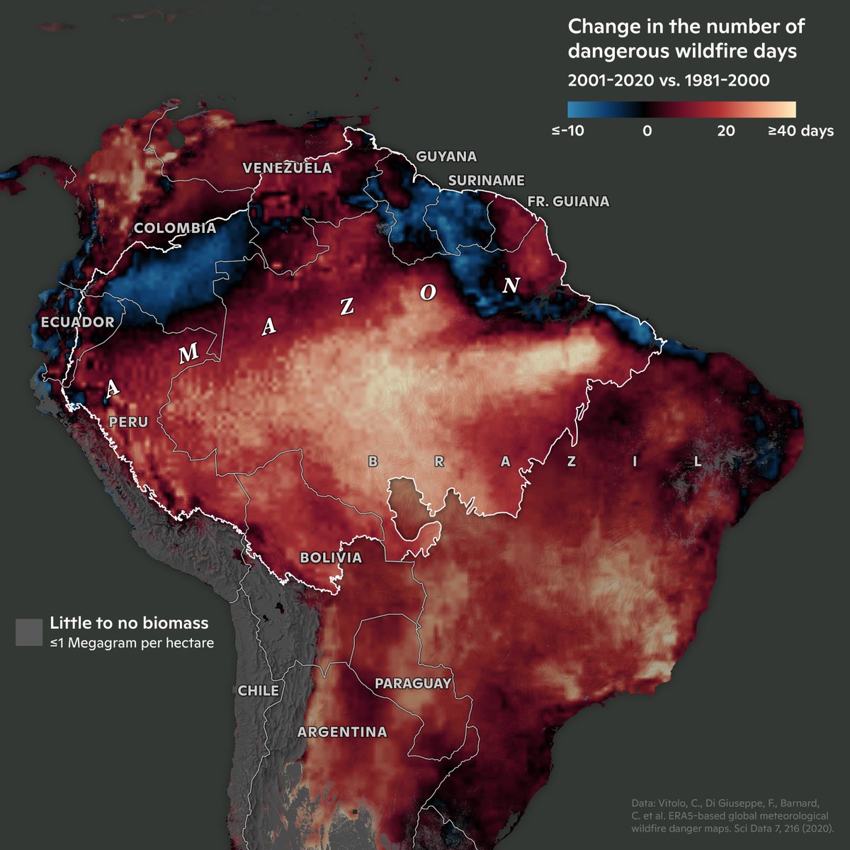
We’re starting Climate Week with a #MapMonday from <a href="/cmshintani/">Christina Shintani</a> that shows what's at stake.

Wildfire danger days, or days considered hot and dry enough for fire, have become a more common occurrence in the Amazon, where previously it was too wet to burn.

ow.ly/PEsG50Ttnjr
Atlas (Chenxiao) Guo (@cartoguophy) 's Twitter Profile Photo

#HurricaneHelene is a tragedy. After making a bilingual news map to show its path and precipitation, I felt driven to contribute more, so I made another map to help identifying areas with power outage by comparing satellite images. Hope this effort counts. cartoguophy.com/maps/hurricane…

#HurricaneHelene is a tragedy. After making a bilingual news map to show its path and precipitation, I felt driven to contribute more, so I made another map to help identifying areas with power outage by comparing satellite images. Hope this effort counts. cartoguophy.com/maps/hurricane…
Greg Fiske (@g_fiske) 's Twitter Profile Photo

With #Milton looming in the Gulf, I'm still caught up in visualizing #Helene. These are steep edges of cloud bands from GOES-16 (band CMI-C13).

Woodwell Climate Research Center (@woodwellclimate) 's Twitter Profile Photo

This map art by Greg Fiske depicts the Kuskokwim River at the confluence of the Kwethluk River in Alaska. Three of the @woodwellarctic partner communities are within this image: Kwethluk, Akiachak, and Akiak. The Kwethluk river is also a major focus for Science On The Fly.

This map art by <a href="/g_fiske/">Greg Fiske</a> depicts the Kuskokwim River at the confluence of the Kwethluk River in Alaska. Three of the @woodwellarctic partner communities are within this image: Kwethluk, Akiachak, and Akiak. The Kwethluk river is also a major focus for Science On The Fly.
mapsdotcom (@mapsdotcom) 's Twitter Profile Photo

Despite accounting for only 0.025% of the mass of Earth’s crust, carbon is vital for life on our planet. Christina Shintani and Greg Fiske of Woodwell Climate Research Center share a gorgeous map showing where carbon is stored in US forests. maps.com/counting-carbo…

Despite accounting for only 0.025% of the mass of Earth’s crust, carbon is vital for life on our planet.

<a href="/cmshintani/">Christina Shintani</a> and <a href="/g_fiske/">Greg Fiske</a> of <a href="/WoodwellClimate/">Woodwell Climate Research Center</a> share a gorgeous map showing where carbon is stored in US forests.

maps.com/counting-carbo…
mapsdotcom (@mapsdotcom) 's Twitter Profile Photo

Cartographer extraordinaire Lauren Tierney joined Esri after making phenomenal maps for the The Washington Post newsroom. See some of her work on snow maps, and even learn how to do it: maps.com/neon-snow-dept…

Cartographer extraordinaire Lauren Tierney joined <a href="/Esri/">Esri</a> after making phenomenal maps for the <a href="/washingtonpost/">The Washington Post</a> newsroom.

See some of her work on snow maps, and even learn how to do it: maps.com/neon-snow-dept…