Cesar Alvites (@cesaralvites2) 's Twitter Profile
Cesar Alvites

@cesaralvites2

Post-doc research at the University of Molise. 🌳🌲🛰🏕🌎

ID: 1142108086691405825

calendar_today21-06-2019 16:32:42

265 Tweet

89 Followers

202 Following
Mike Wulder (@mikewulder) 's Twitter Profile Photo

Tracking shifts in light availability within forest canopies using #lidar data reveals key changes in structural complexity over time. reinis cimdins et al. Quantifying changes in forest structural complexity using bi-temporal airborne laser scanning. #evo doi.org/10.1080/227972…

Tracking shifts in light availability within forest canopies using #lidar data reveals key changes in structural complexity over time.
<a href="/ReinisCimdins/">reinis cimdins</a> et al. Quantifying changes in forest structural complexity using bi-temporal airborne laser scanning. #evo
doi.org/10.1080/227972…
Cesar Alvites (@cesaralvites2) 's Twitter Profile Photo

🌳📊Paper Alert: We developed a web app on GEE to map tree heights Global Forest Watch , e.g., Italian forest GEDI NASAEarthdata! Study: doi.org/10.1016/j.envs… App: …calvites1990.projects.earthengine.app/view/ch-gee ✅ HR map (10m) ✅ App set e.g, ForestMask ✅ High Precision (RMSE-17% for Italy)

🌳📊Paper Alert: We developed a web app on GEE  to map tree heights <a href="/globalforests/">Global Forest Watch</a> , e.g., Italian forest <a href="/GEDI_Knights/">GEDI</a> <a href="/NASAEarthData/">NASAEarthdata</a>!
Study: doi.org/10.1016/j.envs…
App: …calvites1990.projects.earthengine.app/view/ch-gee
✅ HR map (10m)
✅ App set e.g, ForestMask
✅ High Precision (RMSE-17% for Italy)
Saverio Francini (@saveriofrancini) 's Twitter Profile Photo

Congratulations to Cesar Alvites, Hannah O'Sullivan, Erika Bazzato & colleagues! 🎉 Proud to see it take root in the #GEEsummerSchool we organized in Florence. Your working group was - and remains - amazing! 👏Here’s a GIF for you to hopefully bring back some great memories 😁
🌳 TLS TREES 🌳 (@tls_trees) 's Twitter Profile Photo

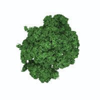
Today we launch a database of 30+ ancient oaks 🌳 captured with #LiDAR For the tree 😍: sketchfab.com/SCATTER.project Sketchfab For the tree 🧑‍🔬: doi.org/10.5281/zenodo… Zenodo Funded by the @WoodlandTrust. With support from Ancient Tree Forum

Remote Sensing MDPI (@remotesens_mdpi) 's Twitter Profile Photo

🌳🌲 Individual #Tree-Crown #Detection and #Species Identification in Heterogeneous #Forests Using Aerial #RGB Imagery and #DeepLearning ✍️ Mirela Beloiu et al. 🔗 mdpi.com/2072-4292/15/5…

🌳🌲 Individual #Tree-Crown #Detection and #Species Identification in Heterogeneous #Forests Using Aerial #RGB Imagery and #DeepLearning

✍️ Mirela Beloiu et al.
🔗 mdpi.com/2072-4292/15/5…
Rosana Ferrero 📈📊🙌 (@rosanaferrero) 's Twitter Profile Photo

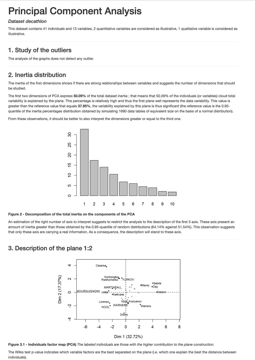
👀 ¿Qué pasaría si el PCA hiciera su propio informe? 🤖 🔥 Con FactoInvestigate, el análisis de componentes principales (PCA) no solo examina tus datos, ¡también genera un informe completo automáticamente! 📝 Pero aquí está lo importante: el control siempre es tuyo.💪🧵 #rstats

👀 ¿Qué pasaría si el PCA hiciera su propio informe? 🤖

🔥 Con FactoInvestigate, el análisis de componentes principales (PCA) no solo examina tus datos, ¡también genera un informe completo automáticamente! 📝 Pero aquí está lo importante: el control siempre es tuyo.💪🧵

#rstats
Martin Mokros 🌳 📷 🇸🇰 🇬🇧 (@m_mokros) 's Twitter Profile Photo

🚨 PhD Opportunity Shape the future of precision forestry! Join an exciting project integrating mobile laser scanning & AI to revolutionise forest management. UCL + Queen Mary University of London+ Forest Research Within NERC TREES Doctoral Landscape Award Apply now! 🌳👉 bit.ly/41rmoc6 #lidar #Forestry #AI
Forest Modelling Lab. (@for_mod_lab) 's Twitter Profile Photo

New Book Release! 𝑴𝒐𝒏𝒊𝒕𝒐𝒓𝒊𝒏𝒈 𝒂𝒏𝒅 𝑷𝒓𝒆𝒅𝒊𝒄𝒕𝒊𝒏𝒈 𝑭𝒐𝒓𝒆𝒔𝒕 𝑮𝒓𝒐𝒘𝒕𝒉 𝒂𝒏𝒅 𝑫𝒚𝒏𝒂𝒎𝒊𝒄𝒔 15 years of groundbreaking research and advanced code development, all in one must-have manual for forest ecosystem modelling! 🌳 #Forestmodelling CNR Consiglio Nazionale delle Ricerche

Saverio Francini (@saveriofrancini) 's Twitter Profile Photo

Using #RemoteSensing in forest inventory designs boosts precision or cuts costs (5-27%)—even with simple predictors (e.g., NDVI). So, why don’t most #EU #NationalForestInventories use it? 🔗 rdcu.be/d20Lt

Using #RemoteSensing in forest inventory designs boosts precision or cuts costs (5-27%)—even with simple predictors (e.g., NDVI). So, why don’t most #EU #NationalForestInventories use it?

🔗 rdcu.be/d20Lt
Matt Finer (@mattfiner) 's Twitter Profile Photo

Nuevo reporte sobre superposición de concesiones mineras con Áreas Protegidas, Comunidades Nativas, Reservas Indígenas (PIACI), y ríos en la Amazonía peruana Se documenta 799 concesiones mineras conflictivas maapprogram.org/es/concesiones… Conservación Amazónica - ACCA,Actualidad Ambiental,SPDA,ONG DAR

Nuevo reporte sobre superposición de concesiones mineras con Áreas Protegidas, Comunidades Nativas, Reservas Indígenas (PIACI), y ríos en la Amazonía peruana

Se documenta 799 concesiones mineras conflictivas

maapprogram.org/es/concesiones…

<a href="/amazonacca/">Conservación Amazónica - ACCA</a>,<a href="/actualidadspda/">Actualidad Ambiental</a>,<a href="/spdaorg/">SPDA</a>,<a href="/ONGDAR/">ONG DAR</a>
Michele Torresani (@torre_mic) 's Twitter Profile Photo

Great discussions after my presentation at @unibz_news "Extreme Weather Events and Adaptation in the South-Eastern Alps" conference. I shared how LiDAR remote sensing helps track forest changes after windstorms like Vaia (sciencedirect.com/science/articl…) & bark beetle outbreaks 🌲🛰️.

Great discussions after my presentation at @unibz_news  "Extreme Weather Events and Adaptation in the South-Eastern Alps" conference. I shared how LiDAR remote sensing helps track forest changes after windstorms like Vaia (sciencedirect.com/science/articl…) &amp; bark beetle outbreaks 🌲🛰️.
Monique Schlickmann (@moniquebschlick) 's Twitter Profile Photo

Thrilled to announce that my 1st PhD chapter on data fusion for canopy cover mapping in Florida has just been published! 🎊🌲📡 Check it out here: mdpi.com/3138712 #RemoteSensing #Forestry #LiDARdata

Thrilled to announce that my 1st PhD chapter on data fusion for canopy cover mapping in Florida has just been published! 🎊🌲📡 Check it out here: mdpi.com/3138712 #RemoteSensing #Forestry #LiDARdata
Michele Torresani (@torre_mic) 's Twitter Profile Photo

Have you ever thought using LiDAR from mobile, terrestrial, and spaceborne GEDI combined with optical and radar satellite data Copernicus EU , to characterize forest structural complexity?🌲🛰️ We did! Check out this paper, led by Patrick Kacic sciencedirect.com/science/articl…

Have you ever thought using LiDAR from mobile, terrestrial, and spaceborne <a href="/GEDI_Knights/">GEDI</a> combined with optical and radar satellite data <a href="/CopernicusEU/">Copernicus EU</a> , to characterize forest structural complexity?🌲🛰️ We did! Check out this paper, led by Patrick Kacic sciencedirect.com/science/articl…
NASAEarthdata (@nasaearthdata) 's Twitter Profile Photo

NASA's HLS project has released new vegetation indices with 30m spatial resolution, enhancing global monitoring for agricultural and other vegetation-focused applications. Dive into the data: earthdata.nasa.gov/news/harmonize… #Vegetation #Agriculture #Nasa

NASA's HLS project has released new vegetation indices with 30m spatial resolution, enhancing global monitoring for agricultural and other vegetation-focused applications. 

Dive into the data: earthdata.nasa.gov/news/harmonize…
#Vegetation #Agriculture #Nasa
ForestSAT (@forestsat) 's Twitter Profile Photo

Dear ForestSAT Community, In preparation for ForestSAT 2026, we have put together a short survey to help us gauge your interest in attending and better plan for it. We greatly appreciate your support! docs.google.com/forms/d/e/1FAI… Thank you, ForestSAT 2026 ForestSAT2026.com

ForestSAT (@forestsat) 's Twitter Profile Photo

🌲Join the ForestSAT 2026 Pre-Conference Virtual Workshop Series! 🗓️ Dates: October 2025 – April 2026 🌐 Format: Online 🔗 Learn more & register: carlos-alberto-silva.github.io/silvalab/Fores…

🌲Join the ForestSAT 2026 Pre-Conference Virtual Workshop Series!
🗓️ Dates: October 2025 – April 2026 
🌐 Format: Online 
🔗 Learn more &amp; register: carlos-alberto-silva.github.io/silvalab/Fores…
ForestSAT (@forestsat) 's Twitter Profile Photo

🌲Join the ForestSAT 2026 Pre-Conference Virtual Workshop Series! Don’t miss our hands-on virtual workshops, starting in less than 3 weeks! 📅 Dates: October 2025 – April 2026 💻 Format: Online 🔗 Learn more & register: carlos-alberto-silva.github.io/silvalab/Fores…

🌲Join the ForestSAT 2026 Pre-Conference Virtual Workshop Series!
Don’t miss our hands-on virtual workshops, starting in less than 3 weeks!
📅 Dates: October 2025 – April 2026
💻 Format: Online
🔗 Learn more &amp; register: carlos-alberto-silva.github.io/silvalab/Fores…
ForestSAT (@forestsat) 's Twitter Profile Photo

🌲 Join us at ForestSAT 2026! 🌍 📅 May 4–8, 2026 | Hybrid – Attend in-person or online 📧 Questions? Reach out at [email protected] Discover the benefits of attending: carlos-alberto-silva.github.io/silvalab/Fores…
ForestSAT (@forestsat) 's Twitter Profile Photo

🌲 Join us at ForestSAT 2026! 🌍 📅 May 4–8, 2026 | Hybrid – Attend in-person or online 📧 Questions? Reach out at [email protected] Discover the benefits of attending: carlos-alberto-silva.github.io/silvalab/Fores…