Adeel Ahmad (@adeal_gis) 's Twitter Profile
Adeel Ahmad

@adeal_gis

Geospatial Educator and Professional

ID: 370268226

linkhttps://adealgis.wixsite.com/adeel-ahmad-geog calendar_today08-09-2011 18:51:05

495 Tweet

591 Followers

1,1K Following
Isaac Corley (@isaaccorley_) 's Twitter Profile Photo

TorchGeo v0.5.2 is now released and available on pypi! This is a patch release with bug fixes and changes to existing code (no new features). Thanks to everyone who contributed! github.com/microsoft/torc…

Adeel Ahmad (@adeal_gis) 's Twitter Profile Photo

🌿🌊Excited to announce the development of a #GEE app for the Mangrove Cover Dataset of Pakistan 🇵🇰, spanning a 5-year interval (1990-2020), from research led by Hammad Gilani 🌍GEE App here: adeelgeog.users.earthengine.app/view/pakistan-… #Mangroves #Pakistan #RemoteSensing

🌿🌊Excited to announce the development of a #GEE app for the Mangrove Cover Dataset of Pakistan 🇵🇰, spanning a 5-year interval (1990-2020), from research led by <a href="/gilanius/">Hammad Gilani</a>
🌍GEE App here: adeelgeog.users.earthengine.app/view/pakistan-…
#Mangroves #Pakistan #RemoteSensing

Xiaoxiang ZHU (@xiaoxiang_zhu) 's Twitter Profile Photo

Curious about #Referring #RemoteSensing Image #Segmentation? It aims at segmenting out the objects from a RS image, given natural language expression. We introduce this new #NLP in #EO task, a dedicated dataset #RefSegRS, and a #LGCE module. paper: ieeexplore.ieee.org/abstract/docum…

Curious about #Referring #RemoteSensing Image #Segmentation? It aims at segmenting out the objects from a RS image, given natural language expression. We introduce this new #NLP in #EO task,  a dedicated dataset #RefSegRS, and a #LGCE module.
paper: ieeexplore.ieee.org/abstract/docum…
Justin Braaten (@jstnbraaten) 's Twitter Profile Photo

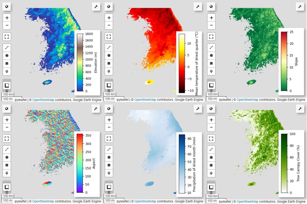
New #EarthEngine tutorial from the developer community just published – a workflow on species distribution modeling 🐦🦋🐯🏞️ 👉 developers.google.com/earth-engine/t… #python #geemap #habitat

New #EarthEngine tutorial from the developer community just published – a workflow on species distribution modeling 🐦🦋🐯🏞️

👉 developers.google.com/earth-engine/t…

#python #geemap #habitat
Mike Wulder (@mikewulder) 's Twitter Profile Photo

Need a remote sensing text book that is free AND full of useful historic and up-to-date information? 🛰️ Info on what was done, why, & how. Ideal way to learn about #satellite #remotesensing. 🆓#OpenAccess digital version of #Landsat’s Enduring Legacy here: my.asprs.org/landsat

Need a remote sensing text book that is free AND full of useful historic and up-to-date information? 🛰️
Info on what was done, why, &amp; how. Ideal way to learn about #satellite #remotesensing.
🆓#OpenAccess digital version of #Landsat’s Enduring Legacy here: my.asprs.org/landsat
Lin Xiong (@lin_umd) 's Twitter Profile Photo

new 12m resultion of global mangrove canopy height map is online! Using TanDEM-X data, calibrated by GEDI GEDI . Very important datasets for coastal forest structure and blue carbon dynamics! daac.ornl.gov/CMS/guides/CMS…

new 12m resultion of global mangrove canopy height map is online! Using TanDEM-X data, calibrated by GEDI
<a href="/GEDI_Knights/">GEDI</a>
. Very important datasets for coastal forest structure and blue carbon dynamics!
daac.ornl.gov/CMS/guides/CMS…
WACV (@wacv_official) 's Twitter Profile Photo

🚨 WACV 2025 Keynote 2🚨 Join Hannah Kerner on March 2nd as she explores “Towards Planetary Intelligence: Machine Learning for Remote Sensing Data.” Discover how AI can drive progress in climate change, food security, and biodiversity through remote sensing data. 🌍 #WACV2025

🚨 WACV 2025 Keynote 2🚨

Join Hannah Kerner on March 2nd as she explores “Towards Planetary Intelligence: Machine Learning for Remote Sensing Data.”

Discover how AI can drive progress in climate change, food security, and biodiversity through remote sensing data. 🌍

#WACV2025
Qiusheng Wu (@giswqs) 's Twitter Profile Photo

🚀 GeoAI Tutorial 21: Training a Segmentation Model for Water Detection from Satellite Imagery — with Just One Line of Code 🛰️ In this tutorial, I demonstrate how to train a deep learning segmentation model to detect water bodies using satellite imagery. While previous tutorials

🚀 GeoAI Tutorial 21: Training a Segmentation Model for Water Detection from Satellite Imagery — with Just One Line of Code 🛰️

In this tutorial, I demonstrate how to train a deep learning segmentation model to detect water bodies using satellite imagery. While previous tutorials
Adeel Ahmad (@adeal_gis) 's Twitter Profile Photo

Organized Summer School 2025 (From Data to Decisions) at Punjab University, Lahore on geospatial tech, AI & climate change. Presented on 'Tree Canopy Height Mapping in GEE'. Thanks Dr. Hammad Gilani for leading the summer school. #SummerSchool #GEE

Organized Summer School 2025 (From Data to Decisions) at Punjab University, Lahore on geospatial tech, AI &amp; climate change. Presented on 'Tree Canopy Height Mapping in GEE'. Thanks Dr. Hammad Gilani for leading the summer school.
#SummerSchool #GEE
Adeel Ahmad (@adeal_gis) 's Twitter Profile Photo

🎓 Just wrapped up my Postdoc (2023–2025) at TaylorGeospatial hosted by WashU! Grateful for an enriching journey in GeospatialAI, amazing supervisor (Nathan Jacobs) and collaborators.🚀 📜 View my postdoc publications: scholar.google.com.pk/citations?user… #Postdoc #GeospatialAI #AI4Earth

🎓 Just wrapped up my Postdoc (2023–2025) at <a href="/TaylorGeoSTL/">TaylorGeospatial</a> hosted by <a href="/WashU/">WashU</a>! Grateful for an enriching journey in GeospatialAI, amazing supervisor (<a href="/jacobsn/">Nathan Jacobs</a>) and collaborators.🚀

📜 View my postdoc publications: 
scholar.google.com.pk/citations?user…

#Postdoc #GeospatialAI #AI4Earth
Qiusheng Wu (@giswqs) 's Twitter Profile Photo

🚨 New Tutorial Alert 🚨 Rendering Google Earth Engine & Cloud-Optimized GeoTIFF Tiles in 3D with Google Earth In this tutorial, I demonstrate how to visualize Google Earth Engine tile layers and Cloud Optimized GeoTIFFs (COGs) directly in Google Earth’s 3D environment. This

Adeel Ahmad (@adeal_gis) 's Twitter Profile Photo

🎉 Hit 5,000 subscribers on my GIS/Remote Sensing YouTube channel! 🌍🛰️ Haven’t posted new content in years, but the learning community keeps it alive 🙌 Grateful for the continued support 💚 Watch and Subscribe: youtube.com/@AdeelAhmad #GIS #RemoteSensing #adeel_geographer

🎉 Hit 5,000 subscribers on my GIS/Remote Sensing YouTube channel! 🌍🛰️

Haven’t posted new content in years, but the learning community keeps it alive 🙌

Grateful for the continued support 💚

Watch and Subscribe: youtube.com/@AdeelAhmad 

#GIS #RemoteSensing #adeel_geographer
Adeel Ahmad (@adeal_gis) 's Twitter Profile Photo

I had the pleasure of conducting a training workshop on “Acquiring Remote Sensing Data using Google Earth Engine (GEE)” on Oct 25, 2025, organized by the Kinnaird College for Women (KCW) , Lahore. #remotesensing #gee #environmentalscience #geography #kinnairdcollege

I had the pleasure of conducting a training workshop on “Acquiring Remote Sensing Data using Google Earth Engine (GEE)” on Oct 25, 2025, organized by the Kinnaird College for Women (KCW) , Lahore. 
#remotesensing #gee #environmentalscience #geography #kinnairdcollege