laurent bryan🇰🇪 (@_85brian) 's Twitter Profile
laurent bryan🇰🇪

@_85brian

”Everyone on this earth is self-centered, the difference is the radius”
,,...
..Gunner!!!

ID: 4832490677

calendar_today21-01-2016 11:14:54

1,1K Tweet

968 Followers

1,1K Following

Kai Lode (@kailodee) 's Twitter Profile Photo

In a world obsessed with instant gratification, remember that true mastery takes time and dedication. There's no shortcut to excellence.

Lucy Chepkochei (@lucychepkosgei) 's Twitter Profile Photo

Geospatial Opportunities · Technical Coordinator GIS- GAVI REACH – Kenya - rescue.csod.com/ux/ats/careers… · WFP - TDY GIS Officer (Afghanistan) - wd3.myworkdaysite.com/recruiting/wfp… · World Vision Kenya Kenya - GIS Officer - Restore Africa Program (Kenya Nationals) - worldvision.wd1.myworkdayjobs.com/WorldVisionInt…

Geospatial Opportunities
· Technical Coordinator GIS- GAVI REACH – Kenya - rescue.csod.com/ux/ats/careers… 
· WFP - TDY GIS Officer (Afghanistan) - wd3.myworkdaysite.com/recruiting/wfp… 
· <a href="/WorldVisionKE/">World Vision Kenya</a> Kenya - GIS Officer - Restore Africa Program (Kenya Nationals) - worldvision.wd1.myworkdayjobs.com/WorldVisionInt…
Robin Cole (@robmarkcole) 's Twitter Profile Photo

TorchSpatial offers a comprehensive framework and benchmark suite designed to advance Spatial Representation Learning (SRL). github.com/seai-lab/Torch…

TorchSpatial offers a comprehensive framework and benchmark suite designed to advance Spatial Representation Learning (SRL).

github.com/seai-lab/Torch…
Md Mijanur Rahman🛰️🗺️🛰️ (@gisrsstudyhacks) 's Twitter Profile Photo

The prediction of future land use/land cover (LULC) changes using the CA-ANN (Cellular Automata - Artificial Neural Network) model Tutorial Link: youtu.be/1rj-vHPC3rI?si… Registration Info: studyhacksgeospatial.com/mastering-land… #remotesensing #gee #googleearthengine

The prediction of future land use/land cover (LULC) changes using the CA-ANN (Cellular Automata - Artificial Neural Network) model 
Tutorial Link: youtu.be/1rj-vHPC3rI?si… 
Registration Info: studyhacksgeospatial.com/mastering-land…

#remotesensing #gee #googleearthengine
PYOFLIFE.COM (@parajulisaroj16) 's Twitter Profile Photo

This book provides an in-depth introduction to using R for spatial analysis and mapping, covering fundamental concepts, techniques, and applications. pyoflife.com/an-introductio… #DataScience #rstats #DataScientists #DataAnalytics #statistics #spatialanalysis

This book provides an in-depth introduction to using R for spatial analysis and mapping, covering fundamental concepts, techniques, and applications. pyoflife.com/an-introductio…
#DataScience #rstats #DataScientists #DataAnalytics #statistics #spatialanalysis
Muhammad Muneeb (@im2muneeb) 's Twitter Profile Photo

Top 8 tools to help you in your literature review. Litmaps Link: litmaps.com/?via=muhammad Scispace Link: typeset.io/?via=muhammad-… Scite_ai Link: scite.ai/?via=muhammad Paperpal Link: paperpal.com/?linkId=lp_726… Use link to get 20% off on all plans via this link. phdtips

Top 8 tools to help you in your literature review.

Litmaps
Link: litmaps.com/?via=muhammad

Scispace
Link: typeset.io/?via=muhammad-…

Scite_ai
Link: scite.ai/?via=muhammad

Paperpal
Link: paperpal.com/?linkId=lp_726…

Use link to get 20% off on all plans via this link.

phdtips
Aditya Dahiya (@adityadahiyaias) 's Twitter Profile Photo

#dataviz #maps A code demonstration and tutorial on using power of #R, {sf} & {terra} for techinques of raster extraction. Getting elevations and land use on points, routes and areas. Code 🔗 tinyurl.com/raster-extract Tools #rstats #sf #ggplot2 #terra #tidyterra by dieghernan ن
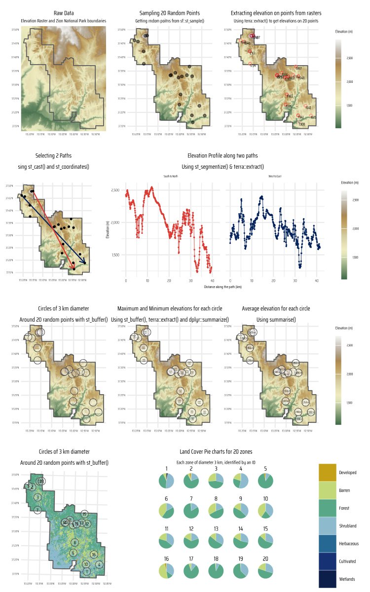
#dataviz #maps A code demonstration and tutorial on using power of #R, {sf} &amp; {terra} for techinques of raster extraction. Getting elevations and land use on points, routes and areas.
Code 🔗 tinyurl.com/raster-extract
Tools #rstats #sf #ggplot2 #terra #tidyterra by <a href="/dhernangomez/">dieghernan ن</a>
Aditya Dahiya (@adityadahiyaias) 's Twitter Profile Photo

#dataviz Code exploring uses of free #OpenSource geographic #raster data on Crop Land by ESA Earth Observation with {terra} in #R to compute % cropland in sub-districts. Data: European Space Agency ESA Climate Office Full Code🔗tinyurl.com/geo-crops-data Tools #ggplot2; {geodata} by Jakub Nowosad, Fer Aramburu
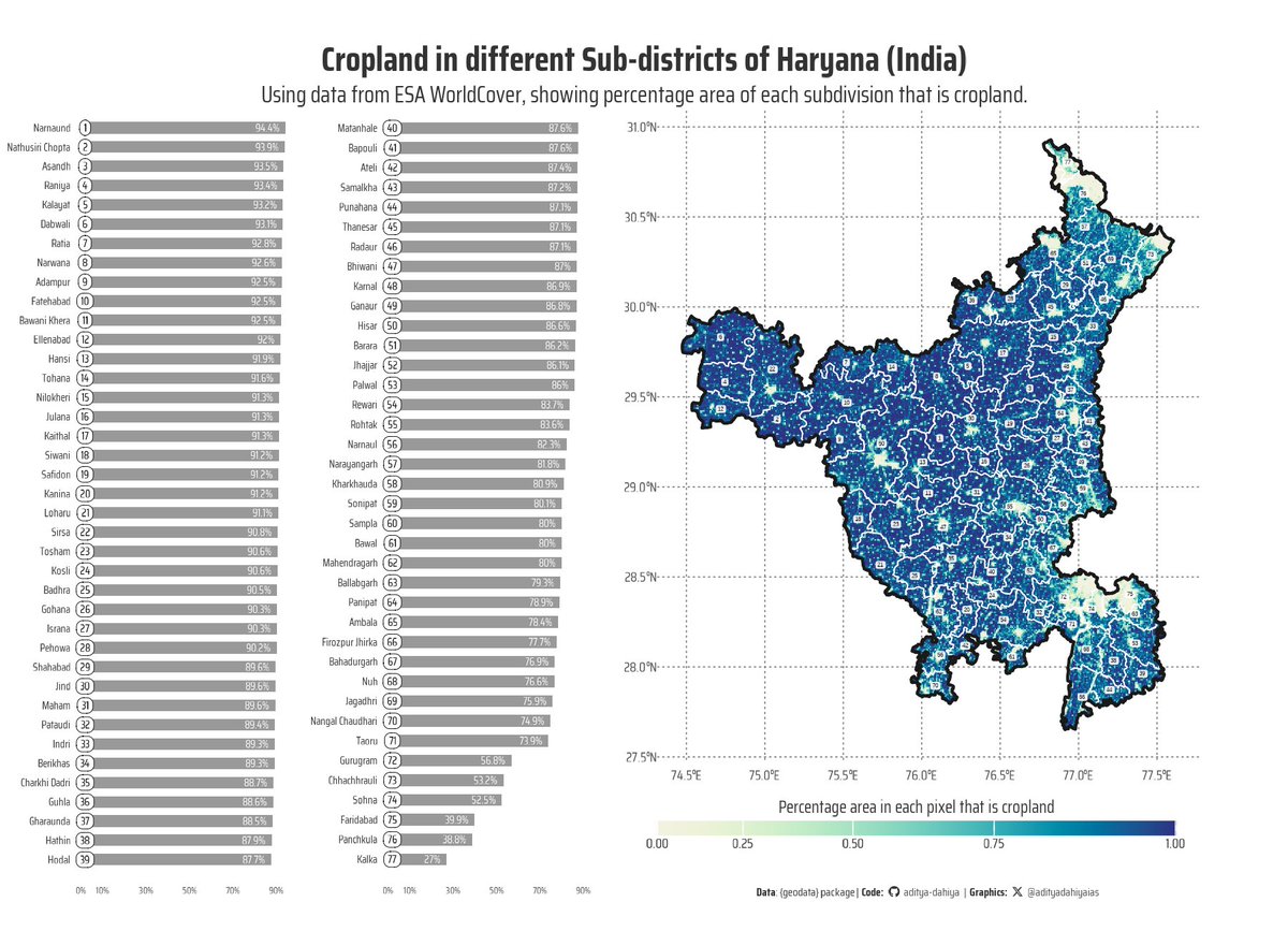

#dataviz Code exploring uses of free #OpenSource geographic #raster data on Crop Land by <a href="/ESA_EO/">ESA Earth Observation</a> with {terra} in #R to compute % cropland in sub-districts.
Data: <a href="/esa/">European Space Agency</a> <a href="/esaclimate/">ESA Climate Office</a> 
Full Code🔗tinyurl.com/geo-crops-data
Tools #ggplot2; {geodata} by <a href="/jakub_nowosad/">Jakub Nowosad</a>, <a href="/FAramburuMerlos/">Fer Aramburu</a>
Hannah Kerner (@hannah_kerner) 's Twitter Profile Photo

📢 The deadline for paper submissions to the Machine Learning for Remote Sensing workshop at #ICLR2025 has been extended to February 10!

📢 The deadline for paper submissions to the Machine Learning for Remote Sensing workshop at #ICLR2025 has been extended to February 10!
Jin Igarashi (@j_igarashi) 's Twitter Profile Photo

maplibre-gl-terradraw v1.2.1 was released. Now you can query elevation from TerrainRGB or Terrarium source (both PNG and WEBP are supported) directly without enabling maplibre terrain! Demo: terradraw.water-gis.com/examples/query… GitHub: github.com/watergis/mapli… #maplibre #terradraw

Gilberto Camara (@gcamara) 's Twitter Profile Photo

#Rstats package sits 1.5.2 is now on CRAN! An end-to-end solution for LUCC mapping of big Earth observation data using ML and AI. Full support for multi-source analytics (SAR + optical + DEM +...). Operational and efficient. See e-sensing.github.io/sitsbook/.

Qiusheng Wu (@giswqs) 's Twitter Profile Photo

The recording of the Leafmap and MapLibre workshop at the The IEEE / CVF Computer Vision and Pattern Recognition Conference (CVPR) 2025, as part of the tutorial on Computer Vision and Artificial Intelligence for Large-Scale Earth Observation Data. Video: youtu.be/MFejuhTrx9I

The recording of the Leafmap and MapLibre workshop at the The IEEE / CVF Computer Vision and Pattern Recognition Conference (CVPR) 2025, as part of the tutorial on Computer Vision and Artificial Intelligence for Large-Scale Earth Observation Data.

Video: youtu.be/MFejuhTrx9I
Vertigo_Warrior (@vertigowarrior) 's Twitter Profile Photo

Want to learn AI from TOP Institute? 🤔 Tihan IIT Hyderabad has launched a 6-month online Course in AI & ML which is top rated in INDIA 🇮🇳 Registration link: bit.ly/iitHydAI - Register for the test with ₹99 - Clear the test & interview - Get selected and secure

Want to learn AI from TOP Institute? 🤔

Tihan IIT Hyderabad has launched a 6-month online Course in AI &amp; ML which is top rated in INDIA 🇮🇳 

Registration link: bit.ly/iitHydAI

 - Register for the test with ₹99
 - Clear the test &amp; interview
 - Get selected and secure