Marcus Humphrey (@92mbh) 's Twitter Profile
Marcus Humphrey

@92mbh

work with maps, enjoy maps

ID: 1694963077

calendar_today23-08-2013 22:25:21

164 Tweet

85 Followers

115 Following

Marcus Humphrey (@92mbh) 's Twitter Profile Photo

Day 13 - Data challenge 2: Natural Earth Using Natural Earth ocean bottom data and turning it into land. With the land masses as ocean. #30DayMapChallenge

Day 13 - Data challenge 2: Natural Earth
Using Natural Earth ocean bottom data and turning it into land. With the land masses as ocean.
#30DayMapChallenge
Marcus Humphrey (@92mbh) 's Twitter Profile Photo

Day 14 - Map with a new tool ... using the great GS software ... Excel. Saw this done by John Nelson at the Scottish Esri Conference in 2018 and went to try it with the same dataset for the last week. #30DayMapChallenge

Day 14 - Map with a new tool ... using the great GS software ... Excel. Saw this done by <a href="/John_M_Nelson/">John Nelson</a> at the Scottish Esri Conference in 2018 and went to try it with the same dataset for the last week. #30DayMapChallenge
Marcus Humphrey (@92mbh) 's Twitter Profile Photo

Day 15 - Map made without using a computer So I decided to part of the Cub Scout local knowledge badge...drawing a map of your local area when I was a cub. #30DayMapChallenge

Day 15 - Map made without using a computer
So I decided to part of the Cub Scout local knowledge badge...drawing a map of your local area when I was a cub.
#30DayMapChallenge
Marcus Humphrey (@92mbh) 's Twitter Profile Photo

Day 17 - Land Using the Land Capability for Agriculture from the James Hutton Institute showing the lower end of the scale where it is improved grassland and rough grazing. #30DayMapChallenge

Day 17 - Land
Using the Land Capability for Agriculture from the James Hutton Institute showing the lower end of the scale where it is improved grassland and rough grazing.
#30DayMapChallenge
Marcus Humphrey (@92mbh) 's Twitter Profile Photo

Day 18 - Water The Tweed is a well known salmon fishing river. Along it's banks are fishing shiels that were used by fishermen. #30DayMapChallenge

Day 18 - Water
The Tweed is a well known salmon fishing river. Along it's banks are fishing shiels that were used by fishermen.
#30DayMapChallenge
Marcus Humphrey (@92mbh) 's Twitter Profile Photo

Day 19 - Island(s) Mapping the Pilgrim's Way to Lindisfarne, showing the safe route across to the island when there is safe crossing. #30DayMapChallenge

Day 19 - Island(s)
Mapping the Pilgrim's Way to Lindisfarne, showing the safe route across to the island when there is safe crossing.
#30DayMapChallenge
Marcus Humphrey (@92mbh) 's Twitter Profile Photo

Day 22 - Boundaries Couldn't do this challenge without a nod to archaeology in there somewhere, especially as the Channel 4 programme Time Team not only shone a light on archaeology but also GIS. Roman coastline compared to modern coastline. #30DayMapChallenge

Day 22 - Boundaries
Couldn't do this challenge without a nod to archaeology in there somewhere, especially as the Channel 4 programme Time Team not only shone a light on archaeology but also GIS. Roman coastline compared to modern coastline.
#30DayMapChallenge
Marcus Humphrey (@92mbh) 's Twitter Profile Photo

Day 24 - Historical I created style set based off the Ordnance Survey Maps 25 inch 1st edition, Scotland, 1855-1882, with the nearby Berwick-upon-Tweed being surveyed in 1855, using modern OS data but in a historical style. #30DayMapChallenge

Day 24 - Historical
I created style set based off the Ordnance Survey Maps 25 inch 1st edition, Scotland, 1855-1882, with the nearby Berwick-upon-Tweed being surveyed in 1855, using modern OS data but in a historical style.
#30DayMapChallenge
Marcus Humphrey (@92mbh) 's Twitter Profile Photo

Day 25 - Interactive Map Scottish Carbon using datasets openly available through ArcGIS Online and Living Atlas. Interactive Map Link - arcg.is/0ajOmL0 #30DayMapChallenge

Day 25 - Interactive Map
Scottish Carbon using datasets openly available through ArcGIS Online and Living Atlas.
Interactive Map Link - arcg.is/0ajOmL0
#30DayMapChallenge
Marcus Humphrey (@92mbh) 's Twitter Profile Photo

Day 26 - Choropleth A very traditional map type on a very traditional map theme. Politics is one of the most mapped areas of human geography. #30DayMapChallenge

Day 26 - Choropleth
A very traditional map type on a very traditional map theme. Politics is one of the most mapped areas of human geography.
#30DayMapChallenge
Marcus Humphrey (@92mbh) 's Twitter Profile Photo

Day 27 - Heatmap Another very traditional way of mapping. Heatmap showing earthquakes over a week earlier this month in North America. #30DayMapChallenge

Day 27 - Heatmap
Another very traditional way of mapping. Heatmap showing earthquakes over a week earlier this month in North America.
#30DayMapChallenge
Marcus Humphrey (@92mbh) 's Twitter Profile Photo

Day 29 - NULL Using Registers of Scotland Inspire Registered Titles data. Inverting the data to show the areas that are unregistered ... so that are NULL. #30DayMapChallenge

Day 29 - NULL
Using Registers of Scotland Inspire Registered Titles data. Inverting the data to show the areas that are unregistered ... so that are NULL.
#30DayMapChallenge
Marcus Humphrey (@92mbh) 's Twitter Profile Photo

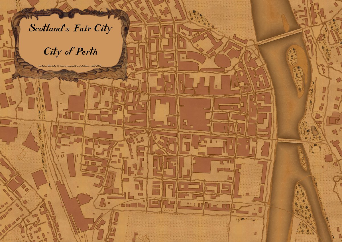
Day 30 - Metamapping Mapping what you want. Two maps today. Map 1/2 Schematic map basing this off of Beck's famous map and using QGIS to create this of Scotland's Fair City of Perth. Map 2/2 Using Aerialod to create a map of the Cairngorms to look like Mars. #30DayMapChallenge

Day 30 - Metamapping
Mapping what you want. Two maps today.
Map 1/2
Schematic map basing this off of Beck's famous map and using QGIS to create this of Scotland's Fair City of Perth.
Map 2/2
Using Aerialod to create a map of the Cairngorms to look like Mars.
#30DayMapChallenge