David Saah (@dsaah) 's Twitter Profile
David Saah

@dsaah

ID: 47862035

linkhttp://www.sig-gis.com calendar_today17-06-2009 05:01:50

423 Tweet

456 Followers

0 Following

Pyregence (@pyregence) 's Twitter Profile Photo

Big news! PyreCast, our fire forecasting model, was featured on kcranews, where they demonstrated how our tool can model fire spread over a period of 2 weeks. Thank you to Zeke Lunder (Zeke Lunder ~ The Lookout) for getting the word to KCRA 3. Watch the video here: youtube.com/watch?v=779cse…

Spatial Informatics Group (SIG) (@sig_gis) 's Twitter Profile Photo

The 9th Annual First Street Report is here! The report is based on wildfire modeling conducted by Pyregence and details how insurance premiums surge across the U.S. due to climate risks. Read more here: cnn.com/2023/09/20/bus… 🔥🌍

Planscape (@ourplanscape) 's Twitter Profile Photo

Experts at USDA Forest Service note a shift: fire season's no longer seasonal; it's year-round. Winter's here, but Planscape is focused on reducing fire risk, boosting ecological benefits, and helping California's landscapes in adapting to #climatechange. 🌲🔥pressdemocrat.com/article/opinio…

Planscape (@ourplanscape) 's Twitter Profile Photo

New report alert! Dept. of Agriculture & USDA Forest Service's Rocky Mountain Research Station just released an in-depth study on #Wildfires, revealing their threats & restoration opportunities. Fuel management is crucial for this balance. Read more: fs.usda.gov/rm/pubs_journa…🌲🔥#FireEcology #FireRisk
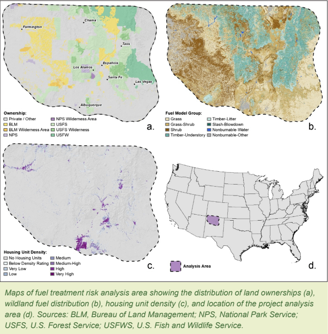
New report alert! <a href="/USDA/">Dept. of Agriculture</a> &amp; <a href="/forestservice/">USDA Forest Service</a>'s Rocky Mountain Research Station just released an in-depth study on #Wildfires, revealing their threats &amp; restoration opportunities. Fuel management is crucial for this balance. Read more: fs.usda.gov/rm/pubs_journa…🌲🔥#FireEcology #FireRisk
Spatial Informatics Group (SIG) (@sig_gis) 's Twitter Profile Photo

📢SIG is #hiring a #Clojure Developer for our Microservices Product team. Work alongside our amazing team of developers, designers, and environmental scientists to streamline analyses through online systems. Read more here: sig-gis.com/career-opportu… #TechJobs #RemoteWork #lisp

Planscape (@ourplanscape) 's Twitter Profile Photo

The 2023 wildfire season broke records for air #pollution in the U.S 🌫️#WildfireSmoke carries serious health risks. Planscape integrates potential smoke emissions metrics under the Air Quality pillar in California, aiding planning decisions. axios.com/us-climate-cha… #ClimateChange

Spatial Informatics Group (SIG) (@sig_gis) 's Twitter Profile Photo

.Pyregence team member Dr. Charles Maxwell and other scientists analyzed 6 forest management scenarios in CA's Central Sierra & found that moderate prescribed burning can mitigate wildfire-related smoke exposures & improve #publichealth. nature.com/articles/s4189… 📚 #Wildfire

Ujaval Gandhi (@spatialthoughts) 's Twitter Profile Photo

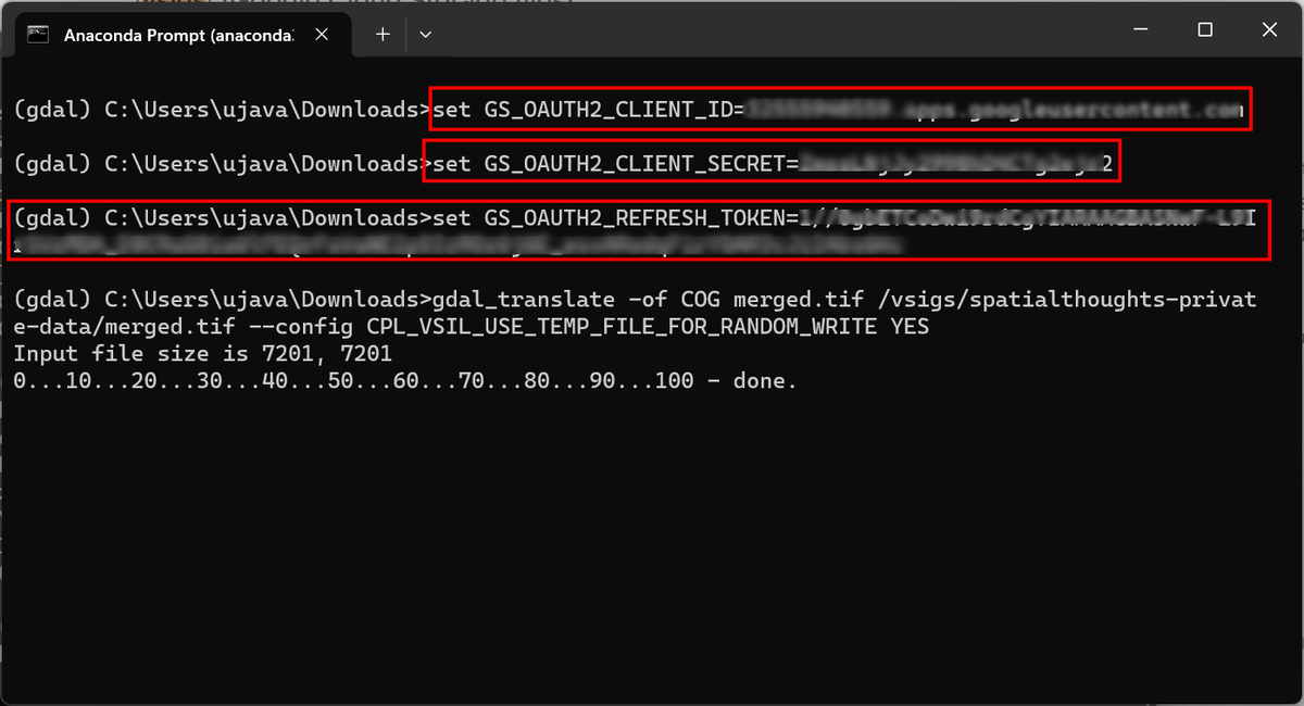
New Post: GDAL and Google Cloud Storage (GCS). GDAL can directly read or write data to a cloud-storage bucket. The tricky part is setting up authentication. I document and explore best practices for using #GoogleCloud Storage with #GDAL Tools. spatialthoughts.com/2024/02/26/gda…

New Post: GDAL and Google Cloud Storage (GCS). GDAL can directly read or write data to a cloud-storage bucket. The tricky part is setting up authentication. I document and explore best practices for using #GoogleCloud Storage with #GDAL Tools. spatialthoughts.com/2024/02/26/gda…
Spatial Informatics Group (SIG) (@sig_gis) 's Twitter Profile Photo

SIG worked with Clere Inc. & Blue Tree Analytics to map burn piles across CA. Funded by the California Joint Institute for Wood Products Innovation, this project examined where piles are located & trends in the burning of piles across air districts.🌲🔥 #CaliforniaWildfires🌐

Planscape (@ourplanscape) 's Twitter Profile Photo

Ready to start treatment planning with Planscape?🌿 Our latest video provides a step-by-step walkthrough on using Planscape for treatment planning across the diverse landscapes of #California! Watch the full video at planscape.org #LandManagement #TreatmentPlanning📽️🌲

Planscape (@ourplanscape) 's Twitter Profile Photo

Planscape will be at FSI today and tomorrow! Join us for live demos showcasing large-scale landscape planning in the Sierras, designed to further #forestmanagement and #wildfireprotection efforts. We hope to see you there! 🔥🌲 #FSI2024

Pyregence (@pyregence) 's Twitter Profile Photo

🔥 With the recent #TexasFires, our PyreCast #fireforecasting tool provides up to 14-day situational awareness information about active fire spread, fire risk & fire weather. With higher-resolution inputs & computational efficiency, check out pyrecast.org now #Wildfire

Spatial Informatics Group (SIG) (@sig_gis) 's Twitter Profile Photo

🌐SIG's David Saah and Teal Richards-Dimitrie visited the WIFIRE lab at San Diego Supercomputer Center to connect with Ilkay Altintas’ team and map out pathways for large open-source community platforms focused on wildfire and landscape resilience and tour SDSC's cutting-edge data center. #GeoAI #GIS

🌐SIG's <a href="/dsaah/">David Saah</a> and Teal Richards-Dimitrie visited the WIFIRE lab at <a href="/SDSC_UCSD/">San Diego Supercomputer Center</a> to connect with Ilkay Altintas’ team and map out pathways for large open-source community platforms focused on wildfire and landscape resilience and tour SDSC's cutting-edge data center. #GeoAI #GIS
Spatial Informatics Group (SIG) (@sig_gis) 's Twitter Profile Photo

🌲 Check out Planscape's new Collaboration Module! ⭐ It lets you invite others to view and collaborate on your plans and create their own scenarios!

Spatial Informatics Group (SIG) (@sig_gis) 's Twitter Profile Photo

🔥SIG employees co-wrote a new paper that provides a precise, quantitative description of a sampling error in #wildfire simulations, offering insights for fire modelers. Findings promise to streamline simulation sizing & convergence assessment. link.springer.com/article/10.100… #Innovation

Planscape (@ourplanscape) 's Twitter Profile Photo

🌲There's a long history of Indigenous fire management practices. 🔥 Planscape values Indigenous wisdom in land management & aims to fuse traditional ecological knowledge into all our solutions. nps.gov/subjects/fire/… #IndigenousKnowledge #PrescribedFires #Sustainability🌳

Spatial Informatics Group (SIG) (@sig_gis) 's Twitter Profile Photo

🌍🌍 We're thrilled to be mentioned in this article about our capacity-building efforts last month in The #Gambia with participants from Liberia. It's a privilege to see our work have an impact on global issues. frontpageafricaonline.com/news/2016news/… 🌿 #CapacityBuilding #Liberia